Download
1 / 21
210 likes | 342 Vues
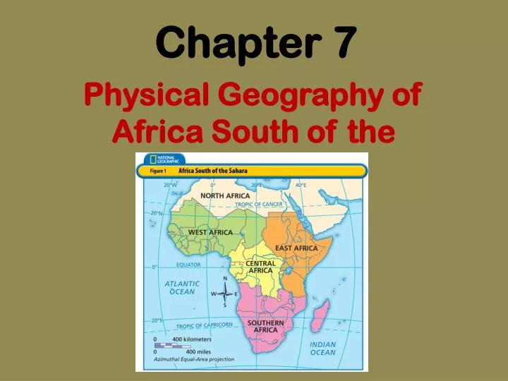
Chapter 7. Physical Geography of Africa South of the Sahara. Name ___________________ #___ Chapter 7 Section 1 (p. 206 – 211) Physical Features. Key Terms: escarpment – steep cliff rift valley – large break in the Earth’s surface formed by shifting tectonic plates

E N D
Chapter 7 Physical Geography of Africa South of the Sahara
Name ___________________#___ Chapter 7 Section 1 (p. 206 – 211) Physical Features Key Terms: • escarpment – steep cliff • rift valley – large break in the Earth’s surface formed by shifting tectonic plates • gorges – steep-sided valleys formed when rivers cut through the land • industrial diamonds – used to make drills, saws, or grinding tools rather than as a gemstone
Plateaus Mountains Landforms Lowlands Great Rift Valley
1. Name the 5 regions of Africa. Which one have we already studied?
Waterways Rivers Lakes Lake Victoria Lake Tanganyika Lake Superior Lake Tana Lake Chad Nile River Zambezi River Congo River Niger River
petroleum natural gas gemstones Resources hydroelectric power gold metals
Chapter 7 – 1 Questions(use text pages 207 – 211) • How was the Congo Basin formed? • How do waterways affect Africans living south of the Sahara? • How large is Lake Chad in the rainy season? How large is Lake Chad in the dry season? • What percentage of Lake Chad disappears in the dry season? • How do some rivers shape the land? • Why do you think oil has replaced agricultural (farm) products as the main export in many countries?
Chapter 7 – 1 Answers • The Congo Basin was formed when tectonic activity lifted up the land surrounding it. • Waterways provide transportation, fresh water, and electricity. • Lake Chad is 10,000 square miles in the rainy season. Lake Chad is 3,800 square miles in the dry season. • 10,000 – 3,800 = 6,200 square miles 6,200 / 100 % = 62% • Some rivers cut through the land and form deep gorges. • Oil has replaced agricultural products because African countries can get more money for oil than they can for agricultural products.
You Decide Water Resources: Who Should Control Them? (text p. 212 – 213) • What does “privatization” mean? • Create a “T-Chart” for and against “privatization.” advantages disadvantages - - - - 3. Do you think privatization is a good idea? Explain why or why not in a quality paragraph. (5 – 7 sentences)
Name ______________#_____ Chapter 7 Section 2 (p. 214 – 218)Climate Regions Key Terms: • drought – period of time when there is no rain at all • rain forest – dense areas of trees and plants that receive more than 80 inches of precipitation per year • canopy – tops of the highest trees form an umbrella-like covering of the rain forests
Key terms continued… 4. deforestation – widespread clearing of forests without planting new trees 5. ecotourism – visiting a place without causing harm to the environment; eco-tourists go to visit a place’s natural beauty 6. savanna – grasslands with scattered trees 7. desertification – process that turns fertile land into desert
Factors Affecting Climate 1. Latitude 2. Precipitation • Most of the region is in the tropics (close to the Equator) • direct sunlight • - Exception = mountains higher elevation = cooler temperatures • Rainforests receive 80 or more inches of rain per year • Deserts receive less than 10 inches of rain per year • Droughts crop failures and starvation
Textbook p. 215 What type of climate borders the deserts?
Tropical and Dry Climates:p. 216 - 217 • Tropical Wet • Tropical Dry • Steppe • Desert • On your poster, you will create a bubble map to describe the climate region. • You must have at least 4 descriptors • Make it colorful and creative
Moderate Climates • Comfortable temperatures • Enough rainfall for farming • Mild winters • South of the Equator, the seasons are opposite of what we experience at the same time. • Ex: When we have summer, they have winter.
Extra Credit • Write a quality paragraph describing a typical summer day or a typical winter day where you live. • Write another quality paragraph describing a typical summer day or a typical winter day in the tropical dry climate region.
Chapter 7 Test-taking PracticeTextbook p. 220 – 221 (1-10) 1. 6. 2. 7. 3. 8. 4. 9. 5. 10. Writing Assessment Practice is EXTRA CREDIT!