Download
1 / 6
60 likes | 215 Vues
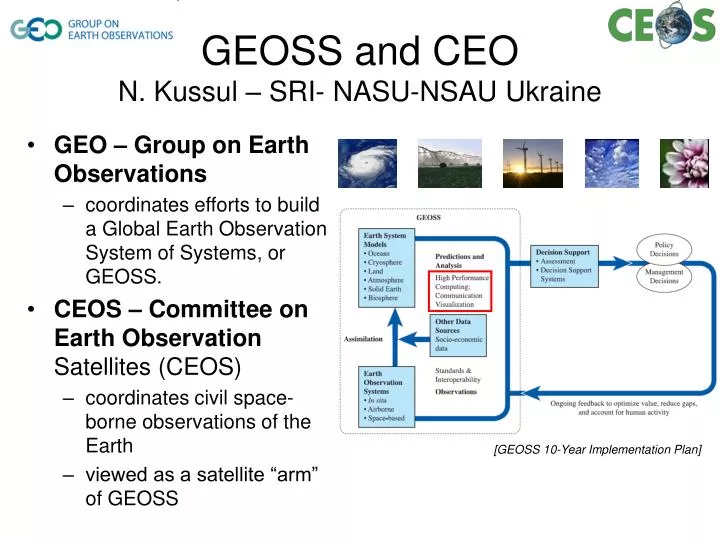
GEO – Group on Earth Observations coordinates efforts to build a Global Earth Observation System of Systems, or GEOSS. CEOS – Committee on Earth Observation Satellites (CEOS) coordinates civil space-borne observations of the Earth viewed as a satellite “arm” of GEOSS.

E N D
GEO – Group on Earth Observations coordinates efforts to build a Global Earth Observation System of Systems, or GEOSS. CEOS – Committee on Earth Observation Satellites (CEOS) coordinates civil space-borne observations of the Earth viewed as a satellite “arm” of GEOSS GEOSS and CEON. Kussul – SRI- NASU-NSAU Ukraine [GEOSS 10-Year Implementation Plan]
CEOS WGISS • WGISS – CEOS Working Group on Information Systems and Services • promotes collaboration in the development of systems and services that manage and supply EO data to users world-wide • Technology Subgroup • Chair: Prof. Natalia Kussul, Ukraine • Grid Interest Group (IG) • Lead: Prof. Andrii Shelestov, Ukraine
Grid IG • Wide Area Grid • collaborative effort of space agencies to share data-processing resources • Testbed • disaster-related applications, particularly floods • GEO 2009-2011 Task # (DI-06-09):Use of Satellites for Risk Management • End-users • UN-SPIDER - United Nations Platform for Space-based Information for Disaster Management and Emergency Response
Rapid flood mapping from SAR satellite imagery in Grids • Delivered within 24 h after data acquisition • Satellite synthetic-aperture radar (SAR) instruments • ERS-2/SAR • ENVISAT/ASAR • RADARSAT-1/2 • Ground validation • Chinese territory on riverHuaihe 2008 => 95% matchof satellite observationsagainst field measurements • Output format • OGC-compatible: WMS, WCS, KML etc Processing workflow
Rapid flood mapping from SAR satellite imagery in Grids (cont.) Vietnam, 2008 China, river Huaihe, 2007 Mozambique, river Zambezi, 2008 India and Nepal, river Koshi, 2008 Zambia, river Zambezi, 2009 Australia, river Norman, 2009
Future plans • Deployment of flood mapping services on EGEE VO ESR / ES SSC • New disaster-related applications within GEO Work Plan • E.g. droughts • Health-related applications within GEO Work Plan • Water-borne infectious diseases vector modelling