Download

1 / 14
290 likes | 807 Vues
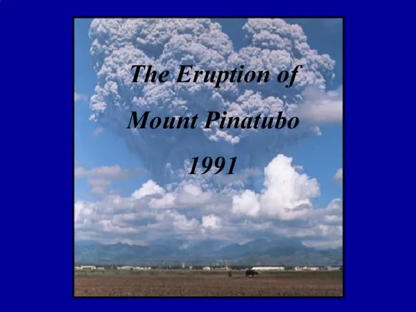
Mt Pinatubo. June 7, 1991. Mt Pinatubo. 15°08′30″N 120°21′00″E 1,485 m (4,872 ft)(current) 1,745 m (5,725 ft) (before 1991 eruption). Maps. Pinatubo. Stratavolcano Formed from a convergent boundary and is usually Felsic composition.

E N D
Mt Pinatubo June 7, 1991
Mt Pinatubo • 15°08′30″N 120°21′00″E • 1,485 m (4,872 ft)(current)1,745 m (5,725 ft) (before 1991 eruption)
Pinatubo • Stratavolcano • Formed from a convergent boundary and is usually Felsic composition. • Felsic eruptions create a lot of ash and little magma. • Very explosive! • Vey common
Plate Tectonics • This a cross sectional map of Mt Vesuvius in Italy. Where Italy is located is very similar to the set up of Pinatubo.
When… • March till June the pre-eruption phase. • Eruption lasted two days. • Post eruption lasted about a year, which altered weather. • Past events: • 35,000 years ago (5 times larger) • 17,000 years ago • 9,000 years ago • 6,000 years ago • 3,000 years ago • 500 years ago
Time line • July 1990, Major earthquake in Luzon • Possible future eruption • March 1991, Series of earthquakes on NW side of mountain. • May 1991, Gases increase. • June 7th 1991, Complete evacuation • June 13th 1991, Explosive eruption (many little explosions before).
What causes this event? • When tectonic plates converge together one plate subducts. • That plate then heats, melts and with the increased friction earthquakes become common. • The shaking from the earthquakes allow the melted rock to rise adding to the pressure. • The lava dome is created. • When the walls cannot hold theforce they explode.
Who is affected? • Everyone within 40 Km was affected directly. • Clark Airbase was evacuated. • Three provinces were affected. • The whole world was impacted from this eruption within a year. • 1992 November NY had ablizzard. Caused from lack of sun light.
Possible Warning • There was a warning that was pretty accurate. • All that people could do was to evacuate. • Evacuation plans were enacted. • Scientists stayed at the base as long as they could to collect data.
Facts • 847 dead • Evacuations saved 10,000 lives • 2.1 million were directly affected. • 150 Km2 of land was destroyed. • 42% of land was destroyed • The GDP of the area dropped 3% after the eruption. • Compare to other events
What If... • Ash was ejected 50 Km or 30 miles up. • Mt Vesuvius in 79 AD was about the same size. • 2011 earthquake swarms recorded with no eruption.
Works Cited • http://volcano.oregonstate.edu/mt-pinatubo-philippines-1991 • http://golearngeo.wordpress.com/2010/03/03/disadvantages-of-volcano/ • http://en.wikipedia.org/wiki/Mount_Pinatubo