Download
1 / 20
230 likes | 632 Vues
Traveling the Silk Road. A Journey from Chang’an to Antioch World Studies B. Chang’an to Dunhuang. By, Natalie Ragazzo, Julie Zink, and Michael Tucker. Chang’an. - Chang’an was the eastern most part of the Silk Road.

E N D
Traveling the Silk Road A Journey from Chang’an to Antioch World Studies B
Chang’an to Dunhuang By, Natalie Ragazzo, Julie Zink, and Michael Tucker
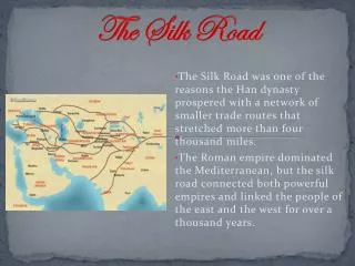
Chang’an -Chang’an was the eastern most part of the Silk Road. -It served as the capital of three major dynasties, the Han, Sui, and Tang. -The land of Chang’an was steppe land. Very dry, flat land that was easy to cross. (picture of steppe land) Natalie Ragazzo
Dunhuang -Dunhuang was a trade post located on the eastern end of the Silk Road where two branches of the route came together. -Summers were hot and dry and winters were cold and dry. -The Mogao Grottoes are famous caves located in Dunhuang decorated with paintings and Buddhist sculptures to give thanks for safe journeys. Julie Zink
Mogao Grottoes • 492 caverns, with 45,000 sq. meters of Buddhist artwork. • Merchants worshiped for safe travels as they continue through the desert on the silk road. • 2.4 thousand painted stone carvings
Dunhuang to Kashgar (Southern Route) By Ryan Bradley and Mimi Matthews
Kashgar Connects the Taklimakan Desert with the Ferghana Valley Important trade center Significant cultural center
Taklimakan Desert • 125,000 square miles • Extreme temperature • Asia’s driest desert • Scarce wildlife
Turpan (Turfan) City located in Northwestern China Lowest point in China (second lowest point on Earth) Extremely hot in summer (119°) and cold in winter (well below 0°) Large water supply underground makes this region very green
Tian Shan Mountains • Located on the border of China and Kyrgyzstan.• Tian Shan means “Celestial Mountains.”• Many glaciers, rivers, and streams throughout the mountains.• The lower part of the mountains are much warmer• When used on the Silk Road, travelers went along the southern edge.
Joshua and Emily Across the Pamirs
The Pamir MountainsBy Emily Goldman • Kashgar-Ferghana Valley • Climate varied: freezing and icy mountain tops to warmer summer times in the lower valleys. • The Kirgiz people live there: owned animals like camel and horses. • The mountains were dangerous in winter. • Also has glacial lakes.
Ferghana Valley Began in Kashgar, near the Pamir mountain ranges -Has fertile soil and is abundant in water -Where the most prized horses in the world are raised - Was the reward for travelers crossing the dangerous mountain crossings
The City of Merv • covers 1,9000 square miles of land • Once a fertile oasis that provided goods for merchants and scholars traveling • Known for its rich soil and vineyards