Download
1 / 1
10 likes | 113 Vues
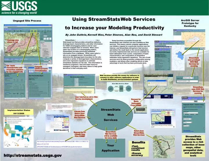
Your Application. Using StreamStats Web Services to Increase your Modeling Productivity By John Guthrie, Kernell Ries, Peter Steeves, Alan Rea, and David Stewart ,. ArcGIS Server Prototype for Kentucky. Ungaged Site Process. Drainage area shown in red.

E N D
Your Application Using StreamStatsWeb Services to Increase your Modeling Productivity By John Guthrie,Kernell Ries,Peter Steeves,Alan Rea, and David Stewart, ArcGIS Server Prototype for Kentucky Ungaged Site Process Drainage area shown in red StreamStats (http://streamstats.usgs.gov) is a Web-based tool that provides streamflow statistics, drainage-basin characteristics, and other information for USGS streamgaging stations and for user-selected ungaged sites on streams. When users select the location of a streamgaging station, StreamStats provides previously published information from a database. When users select a site on an ungaged stream, StreamStats will determine the drainage-basin boundary for the site, compute a variety of drainage-basin characteristics, and solve regression equations to estimate streamflow statistics for the site. This information is needed by engineers, land and water-resource managers, biologists, and many others to help guide decisions in their everyday work. Some functions accessible through the StreamStats user interface are also available as Web services. This means remote computer applications can initiate a request for a particular function over the Internet, and StreamStats will perform that function and deliver the result back to the remote application. Currently implemented web services are available for basin delineation from a point, computation of basin characteristics, and computation of streamflow estimates using regression equations. The use of web services such as these promotes collaboration among modelers, and allows other modeling efforts to take advantage of work that has been previously done. StreamStats uses prototype NHD Web Services for zooming Get basin characteristics and streamflow statistics for the ungaged site Compute additional basin characteristics Web services provide the means for software to connect to other software applications in order to build distributed, service-oriented systems StreamStats uses GNIS Web Services for zooming User Interface to aid in Web Service development Request for Basin Delineation From KWMIP StreamStats Web Services Implementation Status 04/13/2009 Climate Data Return from StreamStats Web Services Return from StreamStats Web Services StreamStats Web Services will be available for every state Request for KY Climate Data from KWMIP StreamStats provides Web access to a rich collection of base maps, other geospatial data, and analytical tools. http://kwmip2.ky.gov/kyclimate/climatedg?request=GetFeature&TIME=1988-01-01/1988-01-02 &bbox=-87,32,-81,38 &PROPERTYNAME=AirTempMean&service=WFSSIMPLE&outputformat=text/xml • Benefits • Fast, consistent results • Known accuracy http://streamstats.usgs.gov