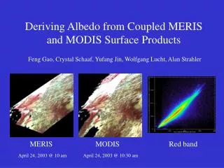
Download
1 / 23
230 likes | 436 Vues
MODIS Albedo Subsets for Selected Field sites. Bob Cook, Steve Margle, Susan Holladay, and Lisa Olsen Oak Ridge National Laboratory Oak Ridge, Tennessee, USA 2nd CEOS/WGCV/ Land Product Validation (LPV) Workshop on Albedo Products Vienna, Austria April 28–29, 2005.

E N D
MODIS Albedo Subsets for Selected Field sites Bob Cook, Steve Margle, Susan Holladay, and Lisa Olsen Oak Ridge National Laboratory Oak Ridge, Tennessee, USA 2nd CEOS/WGCV/ Land Product Validation (LPV) Workshop on Albedo Products Vienna, Austria April 28–29, 2005
Collaborators / Contributors • Jeff Morrisette, Nazmi El Saleous (NASA GSFC) • Crystal Schaaf and Ranga Myneni (Boston University) • Steve Running and Faith Ann Heinsch (University of Montana) • Giri Palanisamy and Tammy Beaty (ORNL)
Goal • To provide subsets of MODIS Land Products in a format and spatial scale useful to field investigators • Facilitates interaction between remote sensing scientists and field investigators • Easily compare satellite data with ground-based measurements • Used for validation of MODIS Land Products
MODIS ASCII Subsets • Subsets of Terra and Aqua MODIS Land Products for 280 sites worldwide (field sites or flux towers) in an easy-to-use ASCII format • 7 km x 7 km centered on flux tower or field sites • Two annual products, four 8-day products, two 16-day product, and calculated albedo, from 2000 to present
BSRN Sites Toravere, Estonia Tateno, Japan Payerne, Switzerland Barrow, Alaska S. Great Plains, Oklahoma Fort Peck, Montana Bondville, Illinois Boulder Colorado Penn State, Pennsylvania Goodwin Creek, Mississippi Other Sites Guzelyayla , Turkey Ovacik, Turkey Arabia1, Saudi Arabia Ngotto Forest, Cent.African Rep. RAC, Central African Republic Nile Delta, Eqypt Novara, Italy Po Valley, Italy Hapex-Sahel, Niger Lamto, Cote D'Ivoire Nigeria, Nigeria Suchow, China Mammoth Mountain, CA, USA ARS-NE PLRC, PA, USA Pleasant Plains, IL, USA Allegheny Nat. Forest, PA, USA MODIS Subset Sites: Albedo Related
Greenland (Denmark) Crawford_Point 2 Crawford_Point 1 DYE-2 JAR1 JAR2 Saddle South Dome SM2 Summit ETH/CU Swiss Camp MODIS Subset Sites: Albedo Related
MODIS ASCII Subset Web Site: http://www.modis.ornl.gov/modis/
Albedo Calculated from MODIS BRDF Product • MODIS BRDF Albedo Model Product (MOD43B1) contains parameters for calculating albedo for visible, near-IR, and shortwave • Black Sky albedo • ƒ(parm 1, parm 2, parm 3, szn) • White Sky albedo • ƒ(parm 1, parm 2, parm 3) • Blue Sky albedo • ƒ(white sky albedo, black sky albedo, optical thickness)
Quality Assurance • Provide quality assurance data layers • Including snow Toravere BSRN, Estonia, January 1, 2005
MODIS ASCII Subsets Web-Based Data Visualization: GridToravere BSRN, Estonia
MODIS ASCII Subsets Web-Based Data Visualization: Time SeriesToravere BSRN, Estonia Visible Broadband Blue Sky Albedo (fraction) Pixel Values Mean Value of Pixels Percent of Pixels that met QC Criteria Year
Additional data compiled for albedo validation • Broadband Diffuse Irradiance Climatology for the selected MODIS ASCII Subset Sites (n = 254) • Based on AERONET data • Prepared by Privette and Hoffman • Available from ORNL ftp://daac.ornl.gov/data/eos_land_val/albedo/ • Subsets of Optical Depth (MOD04) for 24 sites; • Summit, ETH_CU_Swiss_Camp, Tateno, Fort_Peck_Montana, Payerne, BARC, Barton_Bendish, BOREAS_BERMS, Jornada, Lake_Tahoe, Mandalgobi, Metolius_Old_Pine, Tapajos, North_Temperate_Lakes • Available from NASA GSFC ftp://windhoek.nascom.nasa.gov/private/ichoku/MAPSS/
Future Plans: MODIS ASCII Subsets • Continue to offer subsets of Collection 4 MODIS Land Products from Terra and Aqua • Add Continuous Vegetation Field subsets when available • Evaluate current sites and seek additional sites for future processing / reprocessing (e.g., Collection 5 in late-2005) • To have your field site added to the MODIS Subset Collection, we need the geographic coordinates (to four significant decimal places; 10s of meters) and your commitment to share data
Need site location good to 0.0001 degree 1 minute uncertainty yields +/- 2 km or 25 pixels Uncertainty of +/- 1 minute
Future Plans: MODIS Subset Pilot • Tool to enable on-the-fly subsetting and visualization • For any area in North America up to 200 x 200 km • For pre-selected sites for the rest of the world • Incorporate albedo calculation from MOD43B parameters
MODIS ASCII Subsets Web Sitewww.modis.ornl.gov/modis/ Contact: Bob Cook ORNL DAAC cookrb@ornl.gov