Download
1 / 26
270 likes | 328 Vues
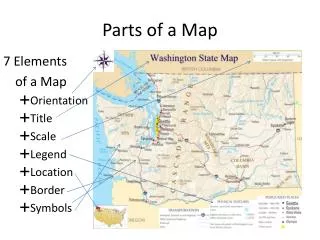
PARTS OF A MAP. Parts of a Map. There are five parts of a map. Title Key (or legend) Scale Compass Rose Grid System What part is NOT on the map on the next slide?. Title tells what the map is showing.

E N D
Parts of a Map • There are five parts of a map. • Title • Key (or legend) • Scale • Compass Rose • Grid System • What part is NOT on the map on the next slide?
Titletells what the map is showing • Always look at a map’s title first. It will tell you what the map is showing you. • For example: rainfall map, population map, physical features map, and political map
Key or Legendexplains symbols • The key or legend explains what the symbols on a map mean. • The most used symbol is color. For example, blue means water on most maps.
Scalemeasures distance • Maps are made to scale. That means there is a direct connection between a unit of measurement on the map and the actual distance. • For example, each inch on the map represents one mile on Earth. So, a map of a town would show a mile-long strip of fast food joints and auto dealers in one inch.
Compass Roseshows direction • A compass is a tool that helps the user know what direction one is headed. • On a map, a compass or a compass rose helps the user locate these directions.
Types of Directions • The cardinal directions are north, south, east, and west. (N, S, E, W) • The intermediate directions are northeast, southeast, southwest and northwest. (NE, SE, SW, NW) • They help describe the location • of places in relation • to other places.
Grid Systemused to locate places on a map • There are two main lines that make up the grid system – latitude and longitude. • Latitude and longitude are measured in degrees. The symbol for degrees is • When listing latitude and longitude you always list latitude first, then longitude. • It should look like this example - 45 N, 62 E. • A comma goes in between the 2 numbers.
Latitude & Longitude “A Way To Find Where You Are on the GLOBE!”
Latitude & Longitude Coordinates • Latitude and longitude are imaginary lines that make it easy to find a location on a map. • Latitude and longitude are two numbers that pinpoint the location of places on the surface of the earth.
A Sphere may be cut in Half Horizontally Creating 2 Hemispheres. The Dividing Line
The Imaginary Dividing Line is Called the Equator Equator - 0° Latitude
Northern & Southern Hemispheres • Latitude lines above the equator are callednorth latitude. • They are in the northern hemisphere. • Those below the equator are called south latitude. • Theyare in the southern hemisphere
Remembering Latitude • The horizontal lines are parallels of latitude. Notice latitude lines are smaller at the top & bottom. • They look like the rungs on a ladder (the part you step on). • Sing to the tune of “The Wheels on the Bus”: • I'm climbing the Ladder of Latitudes, latitudes, latitudesI'm climbing the ladder of latitudes, all around the world.
Latitude • The equator is at 0° latitude. • Degrees of latitude are numbered from 0° to • 90° north and south to the both poles. • While latitude lines run E and W, they are measured N and S because of the equator being their starting point.
More on Latitude • Each of the latitude lines are approximately 69 miles apart. • They are also known as parallels because they never touch.
LONGITUDE “Things That Make You Go HMMMMM?”
If a Sphere is Cut in Half Vertically, the Western & Eastern Hemispheres are Created The Dividing Line
The Imaginary Dividing Line is Called the Prime Meridian Prime Meridian Prime Meridian 0° Longitude
Prime Meridian • The prime meridian goes through Greenwich, England at 0° Longitude
Eastern & Western Hemispheres • Longitude meridians to the left of the prime meridian are called west longitude. • They are in the western hemisphere. • Those to the right of the prime meridian are called east longitude. • Theyare in the eastern hemisphere
Remembering Longitude • Longitude meridians are alllong. They do not change in size.. • Sing to the tune of “The Wheels on the Bus”: • It's a LONG, LONG way from pole to pole, pole to pole, pole to poleIt's a LONG, LONG way from pole to pole, so we call those LONGITUDES
More Longitude While longitude lines run N and S, they are measured E and W because the Prime Meridian is the starting point. They are also known as meridians.
Steps • Check whether it’s in the northern or southern hemisphere. • Determine its latitude. • Check whether it’s in the eastern or western hemisphere. • Determine its longitude. • 5. Use the correct punctuation and capitalization when writing your lat/long.