Download
1 / 1
10 likes | 86 Vues
UNCW Ocean Observing: Providing Infrastructure, Data, and Products to Support State and Federal Agency Needs.

E N D
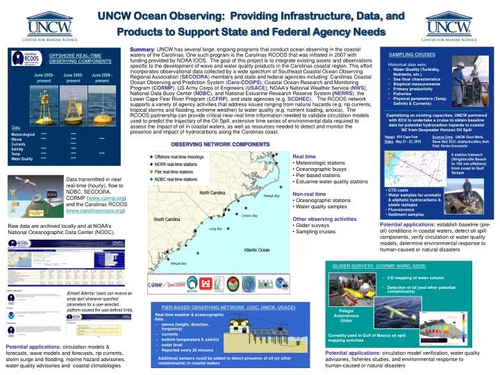
UNCW Ocean Observing: Providing Infrastructure, Data, and Products to Support State and Federal Agency Needs Summary: UNCW has several large, ongoing programs that conduct ocean observing in the coastal waters of the Carolinas. One such program is the Carolinas RCOOS that was initiated in 2007 with funding provided by NOAA IOOS. The goal of this project is to integrate existing assets and observations specific to the development of wave and water quality products in the Carolinas coastal region. This effort incorporates observational data collected by a wide spectrum of Southeast Coastal Ocean Observing Regional Association(SECOORA)members and state and federal agencies including: Carolinas Coastal Ocean Observing and Prediction System(Caro-COOPS),Coastal Ocean Research and Monitoring Program(CORMP),US Army Corps of Engineers (USACE), NOAA‘s National Weather Service(NWS),National Data Buoy Center(NDBC), andNational Estuarine Research Reserve System (NERRS), the LowerCape Fear River Program(LCFRP),and state agencies (e.g.SCDHEC).The RCOOS network supports a variety of agency activities that address issues ranging from natural hazards (e.g. rip currents, tropical storms and flooding, extreme weather) to water quality (e.g. nutrient loading, anoxia). The RCOOS partnership can provide critical near-real time information needed to validate circulation models used to predict the trajectory of the Oil Spill, extensive time series of environmental data required to assess the impact of oil in coastal waters, as well as resources needed to detect and monitor the presence and impact of hydrocarbons along the Carolinas coast. SAMPLING CRUISES OFFSHORE REAL-TIME OBSERVING COMPONENTS • Historical data sets: • Water Quality (Turbidity, Nutrients, etc.) • Sea floor characteristics • Bioptical measurements • Primary productivity • Fisheries • Physical parameters (Temp, Salinity & Currents) June 2005-present June 2005-present June 2008 - present Capitalizing on existing capacities, UNCW partnered with ECU to undertake a cruise to obtain baseline data for potential hydrocarbon hazards to coastal NC from Deepwater Horizon Oil Spill Data Meteorological **** **** Waves **** **** **** Currents **** Salinity **** **** Temp **** **** **** Water Quality **** **** Vessel: R/V Cape Fear Dates: May 21 - 22, 2010 Science Crew: UNCW -Dave Wells, Steve Hall; ECU –Siddhartha Mitra, Nidhi Patel, Kirsten Grossweiler OBSERVING NETWORK COMPONENTS 5 station transect (Wrightsville Beach to 100 nm offshore) from coast to Gulf Stream • Real time • Meteorologic stations • Oceanographic buoys • Pier based stations • Estuarine water quality stations • Non-real time • Oceanographic stations • Water quality samples • Other observing activities • Glider surveys • Sampling cruises Data transmitted in near real-time (hourly), flow to NDBC, SECOORA, CORMP (www.cormp.org) and the Carolinas RCOOS (www.carolinasrcoos.org). • CTD casts • Water samples for aromatic & aliphatic hydrocarbons & stable isotopes • Fluorescence • Sediment samples Potential applications:establish baseline (pre-oil) conditions in coastal waters, detect oil spill components, verify circulation or water quality models, determine environmental response to human-caused or natural disasters Raw data are archived locally and at NOAA’s National Oceanographic Data Center (NODC). GLIDER SURVEYS (CORMP, NURC, IOOS) • 3-D mapping of water column • Detection of oil (and other potential contaminants) Email Alerts:Users can receive an email alert whenever specified parameters for a user-selected platform exceed the user-defined limits. PIER-BASED OBSERVING NETWORK (USC, UNCW, USACE) Pelagia Autonomous Glider Real-time weather & oceanographic data. • waves (height, direction, frequency) • currents • bottom temperature & salinity • water level • Reported every 30 minutes Currently used in Gulf of Mexico oil spill mapping activities AQUARIUS NOAA’s Undersea Research Center (NIUST, Four additional NOAA centers, NASA, logistics from Virginia to Texas) Potential applications:circulation models & forecasts, wave models and forecasts, rip currents, storm surge and flooding, marine hazard advisories, water quality advisories and coastal climatologies Potential applications:circulationmodel verification, water quality advisories, fisheries studies, and environmental response to human-caused or natural disasters Additional sensors could be added to detect presence of oil (or other contaminants) in coastal waters