Download
1 / 33
330 likes | 447 Vues
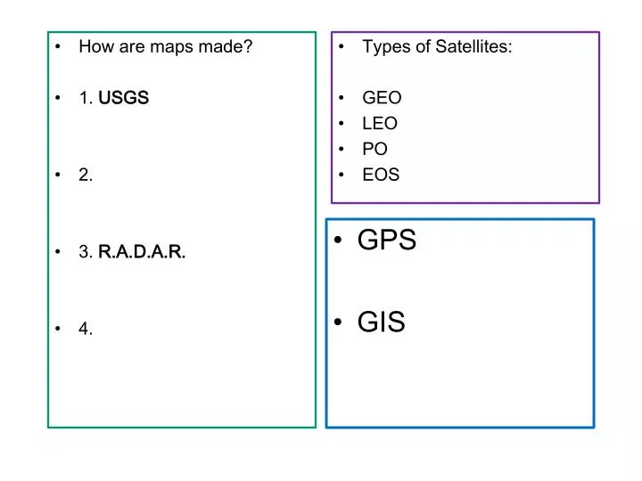
How are maps made? 1. USGS 2. 3. R.A.D.A.R. 4. Types of Satellites: GEO LEO PO EOS. GPS GIS. Sec. 3.2 pg. 48 Technology and Mapping. Oldest maps 2300 B.C. When land ownership, and travel became important. 1. Original Cartographers. Plane table Surveying

E N D
How are maps made? • 1. USGS • 2. • 3. R.A.D.A.R. • 4. • Types of Satellites: • GEO • LEO • PO • EOS • GPS • GIS
Sec. 3.2 pg. 48Technology and Mapping • Oldest maps 2300 B.C. • When land ownership, and travel became important.
1. Original Cartographers • Plane table Surveying • USGS (United States GeologicalSurvey) Founded 1879 • Plane-table map making • Climb to highest point, measure and draw • Ground surveying • Continued till 1940’s
2. Aerial photography • Airplanes! • WWI, WWII, 1900’s • Took aerial photographs using visible daylight • Cameras on planes Hiroshima after the atomic bomb Stereograms and ppt. “What in the world is This?”
3. R.a.d.a.r.Radio detection and ranging • Uses radio waves • Can see through clouds and at night. Doppler weather radar
Remote Sensing“eye in the sky” Using satellites
4. Satellite Mapping • In 1972, NASA launched Landsat1 satellite. • the most recent, Landsat 8, was launched in 1999. • it maps Earth in a 16-day repeat cycle. • a swath 185 km wide as it passes overhead. • provides high-resolution image information of the Earth's surface.
Satellite Images • False Color • Computers process images (pg. 42 in your text book.) • not true-to-life • Can be more useful http://www.youtube.com/watch?feature=player_embedded&v=jHz5kMMavas NASA time lapse Earth 30 yrs.
A satellite in geosynchronous (GEO) or geostationary orbit used for weather forecasting, satellite TV, satellite radio and most other types of global communications.
1. Geosynchronous (GEO) or geostationary • A satellite in geosynchronous (GEO) or geostationary orbit moves ‘with the earth’ • Appears to be “parked” in one spot far above earth, 22,300 miles out in space. • It circles the planet once in 24 hours. • It travels at the same speed and the same direction as the Earth rotates. • So, it always stays directly over the same spot on Earth.
2. Low Earth Orbit (LEO) • A satellite that circles close to Earth. • Just 200 - 500 miles (320 - 800 kilometers) high. • Because they orbit so close to Earth, they must travel very fast so gravity won't pull them back into the atmosphere (17,000 miles per hour!) They orbit Earth in about 90 minutes. • Ex: weather, remote sensing satellites
3. PolarOrbiting satellites • A particular type of Low Earth Orbit. • Polar orbit travels a north-south direction, rather than the more common east-west direction. • Can collect images of the entire earth in 24hours.
EOS • NASA’s Earth Observing System is a series of polar-orbiting satellites for long-term global observations (data)of the biosphere, solid Earth (geosphere), atmosphere, and hydrosphere (oceans) • They collect climate data in the areas: radiation, clouds, water vapor, precipitation,greenhouse gases, land-surface hydrology, ecosystems,; glaciers, ozone, aerosols. • EOS enables an improved understanding of the Earth as an integrated system.
Bell work LEO GEO PO EOS • 22,000 miles above earth • Stays over the same spot on earth • 200-500 miles above earth • “spy” satellite • Collects data not pictures • Takes 90 min. to orbit the earth • Can take a picture anywhere on earth in 24 hrs
Bell work:Three-of-a-Kind • 3 types of maps: • 3 kinds of map scales: • 3 ways to describe latitude: • 3 numbers needed to describe longitude • 3 ways that maps were originally made: • 3 types of satellites:
Global Positioning System The Global Positioning System (GPS) is a U.S.-owned utility that provides users with positioning, navigation, and timing (PNT) services. Maintained by the Air Force 1. Network of 24+ satellites 2. signal receivers 3. Control centers that track, monitor and analyze signals
What can GPS do… • Give information on • Location (within 3 feet) • Latitude and longitude • Elevation • Speed/velocity • Direction/navigation • Real-Time mapping • Tracking paths • Distances • Precise Time
GPS location uses the principle of Triangulation • Data from one satellite can determine your distance, but it could be anywhere on a flat area.
Data from two satellites can narrow down your location to a smaller overlapping area.
But…data from three satellites can determine your precise location within a few feet! Triangulation
GIS • Geographic Information Systems • Powerful computer SOFTWARE designed to • collect, manipulate, store, and display, analyze spatial INFORMATION • Use the information to make maps.
GIS Combines data from • -Satellites • -Land surveys • -Statistical surveys • -Census and demographic data • Data is “sandwiched” into LAYERS to make a map • Different layers “parts” tell a whole “story”
What info. would you need to determine where an airport should be built?(pg 52 in text) 1. Is there enough open land? 2. Is the land (elevation) flat? 3. Are there highways, roads to get to it? 4. Is there enough population nearby to use it?
Spatial (visual) Data Consists of POINTS: - towns, cities, state capitols - stop signs, fire hydrants etc. Consists of LINES: - highways, roads, fault lines, -railroads, utility lines. ….. Consists of coloredAREAS (polygons) - countries, states, forest, lakes, - school districts, land use, soil types. . . .
Why make GIS Maps? • Helps tosee patterns, connections in data (that spreadsheets can’t show) • Solve problems (for businesses and governments) • Answer questions • Make better decisions (using data) • See trends • Perform scientific queries (ask ??) GIS Activity on computer: www.nationalatlas.gov Mapmaker