Download
1 / 25
250 likes | 448 Vues
Description Of The JPL Planetary Web Mapping Server. Lucian Plesea, Elaine Dobinson, Dave Curkendall - JPL Trent Hare – USGS, Flagstaff. http://webgis.wr.usgs.gov/ogc http://onMars.jpl.nasa.gov. ISPRS Workshop, March 17, 2007. Outline. Open Geospatial Consortium Standards

E N D
Description Of The JPL Planetary Web Mapping Server Lucian Plesea, Elaine Dobinson, Dave Curkendall - JPL Trent Hare – USGS, Flagstaff • http://webgis.wr.usgs.gov/ogc • http://onMars.jpl.nasa.gov ISPRS Workshop, March 17, 2007
Outline • Open Geospatial Consortium Standards • OnMars / OnMoon Project Overview • Server Description • Examples and integration scenarios Plesea / Hare
define: OGC Web Services • Currently Addressed • WMS: Web Map Service – simple image • WCS: Web Coverage Service – complex data • Closely Related Services • WFS: Web Feature Service –features • WPS: Web Processing Service – data processing • Catalog Service – metadata spatial searching • GeoRSS – RSS feed + geospatial coordinates Plesea / Hare
OGC Web Mapping/Coverage Services WMS/WCS Plesea / Hare
Benefits to Using Standards • Don’t reinvent the wheel • Leverage existing languages, structures, and solutions • Reach a wider audience • Widely used applications have built-in support for accessing standard services • Evolution • Well-maintained services evolve along with standards, extending their healthy lifespan; data / software / server persistency • NASA OGC interoperability report showed a 30% savings Helps make the data the focus, not the application Plesea / Hare
Project Overview • Promote web mapping services for planetary applications • Standardize planetary coordinate systems with the OGC • Develop WMS and WCS servers for Mars and Lunar data • When necessary, prepare GIS data sets • Adapt GIS (client) applications for Mars and Lunar GIS • Test and propose further integration with PDS Imaging Nodes • Updated USGS/PDS Map-a-Planet has incorporated WMS and planetary encodings Plesea / Hare
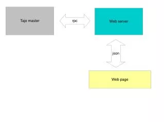
Planetary WMS Block Diagram HTTPD (Apache) Tiled WMS & KML WMS Server (CGI) Tiled WMS KML Network Image Remote Storage Cache Storage • Relative size is not significant • Only data flow is represented Plesea / Hare
Raschal, 40TB cluster RAID Again System using Commodity Hardware And Linux Plesea / Hare
Outline of Major Server Features • Data sets • Planet specific CRS, IAU2000 as the namespace • Style Layer Descriptions (SLD) extensions • Cache/Tile support • Support for 16, 32 bit data requests (Geotiff) Plesea / Hare
Features – Data sets • Mars • MOLA DEM and Slope - Global Topography, Goddard • Request as topography, colorized, shaded, slope • Mars Digital Image Mosaic 2.1, USGS • THEMIS Infrared (IR) Mosaics, ASU • MOC Narrow Angle Mosaic, USGS/JPL • Working on a THEMIS VIS mosaic, ASU • Moon • Lunar DEMs and Slope (ULCN2005), Goddard and USGS • Clementine 750nm UVVIS and NIR Mosaics, 16bit, 11 bands, USGS • Airbrushed Hillshade (Grey and Color), USGS Plesea / Hare
Features - OGC Planetary Coordinate Reference System • Planetary Namespace based on IAU2000 report and using NAIF codes for base value. GEOGCS["GCS_Mars_2000",DATUM["D_Mars_2000", SPHEROID["Mars_2000_IAU",3396190.0, 169.89444722361]],PRIMEM["Reference_Meridian",0.0], UNIT["Degree",0.0174532925199433] http://www.lpi.usra.edu/meetings/lpsc2006/pdf/1931.pdf Plesea / Hare
Features – SLD / Processing WMS • SLD implementation increases server-side processing requirements • Supports most SLD RasterSymbolizer: band selection, gamma correction, linear scaling, histogram equalization, color look-up • Jpeg, PNG and GeoTIFF formats • Geographic, Orthographic and Gnomonic projections (planet specific) Plesea / Hare
Features – SLD / Band Arithmetic(server side) • Band Arithmetic – e.g. Clementine mineral ratios Red=750 nm/415 nm Green=750 nm/950 nm Blue=415 nm/750 nm SLD encapsulation: prefix notation /_b1_b2,/_b1_b3,/_b2_b1 Currently supports arbitrary length formulae, four basic operations and constants Plesea / Hare
Features – Cache/Tiled WMS • WMS needs a mechanism to expose caches • Add one request type, getTileService • Returns an XML wrapped list of WMS requests, used as template • Image data is delivered only by WMS • Compatible with WMS 1.1.1 and SLD • OnMars Tiled WMS has latencies in the order of milliseconds Plesea / Hare
Selected Clients • NASA WorldWind, uses tiles • WorldKit, flash WMS viewer using tiles • GoogleEarth, full WMS client, uses tiles • WMSConnect, ESRI arcscript to use WMS images as data, ArcGlobe uses tiles • JMars • PIGWAD • JUMP, OpenLayers, OpenEV, Global Mapper, uDig (geoTools) , gvSIG Plesea / Hare
Google Earth – WMS Client • Use refresh style onRegion • Data Transport is a WMS request • KML request is almost a WMS request. • Returned KML can include sub-regions • Requires Google Earth 4 or later, on a platform that allows arguments • This functionality integrated in OnMars Tiled WMS server Plesea / Hare
Planetary WMS Block Diagram (review) HTTPD (Apache) Tiled WMS & KML WMS Server (CGI) Tiled WMS KML Network Image Remote Storage Cache Storage • Relative size is not significant • Only data flow is represented Plesea / Hare
Planetary OGC Examples JPL’s WMS onMars: showing Mars Topography (with SLD – Style Layer Desc.) Plesea / Hare
Planetary OGC Examples NASA’s Worldwind accessing JPL’s WMS server (16 bit Png for topo, Image texture, topography colorized using SLD and transparent over image) 2X Plesea / Hare
Planetary OGC Examples Multiple Servers JPL’s OnMars, USGS’s PIGWAD, ASU’s JMars Plesea / Hare
WMS Connect (client builds local layers) Novel use of WMS servers Plesea / Hare
Sparse Data Support – MOC NA MGS Mars Orbiter Camera Narrow Angle mosaic • A 0.5 arc-second composite of more than 50,000 high resolution images of Mars, located between 75N and 75S • It is an uncontrolled mosaic, the images are placed on the global frame based on the best known location, using a simple warp. Location errors are common, but it does match MDIM and MOLA rather well • The mosaic contains more than 300GB of raw image data, and images are still to be released • Credits: MSSS/JPL/Caltech/USGS/ASU/UofA/NASA • Tackle an uncontrolled THEMIS VIS mosaic also. Plesea / Hare
Planetary OGC Examples Live MOC NA Image Mosaic, ~50K images, ~3TB mosaic stored as 130GB Plesea / Hare
NULL data masks Plesea / Hare
JPL Server Optimization, WorldKit (flash-based viewer) Moc NA Mdim2.1 Themis GE Plesea / Hare