Download

1 / 28
280 likes | 531 Vues
Data Acquisition. GPS for Fire Management & ICS - 2006. Objective: Learn Where and How to Acquire GIS Data for Map Making. Summary of Topics: What Data Do You Need? Does it Exist Locally? Web Availability Data for Purchase. Data Needs.

E N D
Data Acquisition GPS for Fire Management & ICS - 2006
Objective: Learn Where and How to Acquire GIS Data for Map Making
Summary of Topics: • What Data Do You Need? • Does it Exist Locally? • Web Availability • Data for Purchase
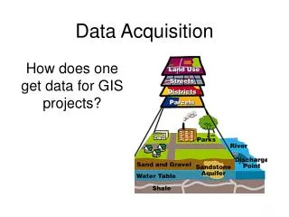
Data Needs • Data requirements depend upon what products the situation unit needs • Base data • static layers • raster data (e.g., DRGs) • vector data (e.g., wilderness boundaries) • Incident data- • data tied directly to an incident (e.g., fire origin) • GPS data for points, lines, perimeter
Data Needs • Where and How Can You Acquire Base Data?
Where’s the Fire? • Home Unit • ask GIS staff • search data library on servers or CDs • Traveling • get base data before you go • may not have internet access • GIS data is usually large • connect with Local Staff when you arrive
ftp.nifc.gov • \Statewide_GIS_Data • Interagency ftp site that allows base data download via anonymous login • Posting data requires a login • Data was posted by BLM Regional Office contacts • DRGs and other data are available for the Western US and Alaska
ftp.nifc.gov • \Incident_Specific_Data • Organized by fire name • One directory per incident • Incident directories • GISS request • FTP site manager creates • Username and password • passed on to existing and new teams
Fire Data Ordering Sitehttp://firedata.cr.usgs.gov • Developed by USGS • DRGs, DEMs, shaded relief, DOQs • requested projections • Vector fire data • Free Download • MODIS, AVHRR, • current fire locations • fire perimeters • base data layers *User name and password: FireXdata
Fire Data Ordering Site • Restricted to Fire personnel • Access to additional datasets • Vector data - ArcIMS extract tool • Order custom raster data: DRG, DOQ, DEM, shaded relief with fire number
One Website Many Links http://sierrafire.cr.usgs.gov/fire_gis_webpage.htm
Other Websites for Data • BLM & USFS joint effort of the BLM and the FS http://www.geocommunicator.gov/ • FGDC Clearing House Node • http://clearinghouse1.fgdc.gov • GAP Land Cover (30 – 100 meter resolution) • http://www.gap.uidaho.edu/Projects/States/ • GEODATA.GOV Geospatial One-Stop • http://www.geodata.gov/gos • Geography Network • http://www.geographynetwork.com/ • GISUSER.COM ESRI Sponsored Data Miner • http://www.gisuser.com/content/view/607/28/
More Websites… • National Atlas • http://nationalatlas.gov/atlasftp.html • NED NLCD Land Cover/DEM National Map • http://seamless.usgs.gov/Use “View & Order” • NHD National Hydro Data • http://nhd.usgs.gov/data.html • NLCD National Land Cover Data • http://www.epa.gov/mrlc/data.htmlState Coverages • NWI National Wetlands Inventory Data • http://wetlands.fws.gov/webstat.gif • ftp://www.nwi.fws.gov/shapedata
Buy Data • TOPO! Xport Pro • National Geographic Product • $200 • 1:500,000 & 1:100,000 Resolution Shaded Relief • Entire US – 50 States • Export to GeoTiff • Single State Series 1:24,000
When You Get There…Get Connected • Find out who the local GIS folks are…. • City / County Sheriff support offices • Land management agencies GIS coordinators • Request a cell phone from the Communications Unit if necessary • You may be first on the incident • Establish FTP/Internet Connection
Reasons for Knowing the Locals • They will inherit the incident • They have data that you may benefit from • They may be able to help you if you need additional hardware or supplies • Example: Plotters (Lease?) or external hard drive.
Summary of Topics: • What Data Do You Need? • Does it Exist Locally? • Web Availability • Data for Purchase