Download
1 / 17
170 likes | 323 Vues
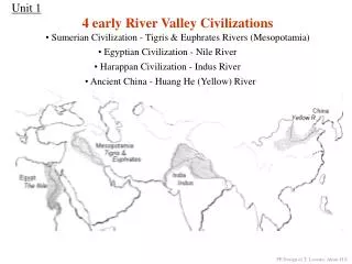
South Llano River: One of 2011’sTop Ten. National Fish Habitat Action Plan named SLR as “water to watch” WHY?? Conserve freshwater, estuarine, and marine habitat For more information go to www.fishhabitat.org. Guadalupe Bass Initiative.

E N D
South Llano River: One of 2011’sTop Ten • National Fish Habitat Action Plan named SLR as “water to watch” • WHY?? • Conserve freshwater, estuarine, and marine habitat For more information go to www.fishhabitat.org
Guadalupe Bass Initiative • Central Texas endemic (streams of the Edwards Plateau region) • State Fish of Texas • Declining numbers • Decreased stream flow • Habitat degradation • Hybridization with smallmouth bass
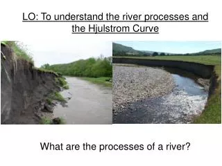
A Watershed • An area that drains to a common waterway, such as a stream, lake, estuary, wetland, aquifer, or even the ocean. Source: http://water.epa.gov/type/watersheds/index.cfm
What Does a Watershed Look Like? • There are watersheds of all types • They can include farmland, rangeland, small towns or large cities • They can be only a few acres to millions of square miles • Watershed have four major features: uplands, floodplains, riparian zones, and water-bodies WE ALL LIVE IN ONE!! Source: Texas Watershed Stewardship Program Workshop April 2010
Uplands • Area of land above a water-body • Typically forms watershed boundaries • Provides habitat for wildlife, minimizes soil erosion and acts a filter Source: Texas Watershed Stewardship Program Workshop April 2010
Floodplains • Flat land that surrounds a water-body that is prone to flood events • Traps excess water • Filters sediment • Provides habitat for wildlife Source: Texas Watershed Stewardship Program Workshop April 2010
Riparian Zone • “River Bank” • Interface between land and water-body • Filters sediment and surface runoff • Minimizes soil erosion • Provides habitat for wildlife Source: www.wikipedia.org
Water-Body • Stream, river, pond, lake, reservoir, estuary, bay, or ocean • Flowing (lotic) or non-flowing (lentic) • Influence and affected by soil, slope, vegetation and topography Source: Texas Watershed Stewardship Program Workshop April 2010
Watershed hydrology • Hydrology is the study of water • 70% of the Earth’s surface is water • Water continually cycles through a process known as the water cycle
Where Does the Rain Go? • Runoff • Absorb by plants and used for photosynthesis • Infiltrate soil and percolate down into groundwater aquifers • Evaporation • Trapped in ice caps, glaciers, lakes, and reservoirs Source: Texas Watershed Stewardship Program Workshop April 2010
Land Use/Land Cover • Land use is how WE use the land • Agriculture, industry, urban, recreation • Land Cover is the physical and biological features • Forests, grassland, rivers, buildings • Changes can effect watershed function
Watershed Functions • Hydrological • Water capture: captured from rainfall and infiltrates into soil • Water storage: stored in areas between soil particles and soil profile • Water release: released underground, through soil, or across land Source: Texas Watershed Stewardship Program Workshop April 2010
Watershed Functions • Ecological • Provides areas for nutrient transformation found in air, water, and soil • Provides habitat for plants and wildlife Source: Texas Watershed Stewardship Program Workshop April 2010
Benefits of a Watershed Approach • Hydrologically and geographically defined • Considers many stressers (air, water, land) • Includes all stakeholders • Agencies (federal, state,& local) • Community-based • Identifies and prioritizes water resource issues (e.g. water quality, water quantity, invasive species) Source: http://water.epa.gov/type/watersheds/approach.cfm
What is a Watershed Conservation Plan? • Helps identify and prioritize issues facing the watershed • Framework for community participation in land and water management with regard to issues • Guide restoration efforts with regard to important species (e.g. Guadalupe Bass)
So, Why the Upper Llano River Watershed? • EPA’s Healthy Watersheds Initiative • Collaborative systems-approach to protecting healthy watersheds • Why do it? • Provides clean water for healthy ecosystems • Habitat for fish and wildlife • Drinking water • Recreational opportunities • Reduces vulnerability from negative impacts (e.g. land use changes, exotic & invasive species)