Download
1 / 83
840 likes | 1.03k Vues
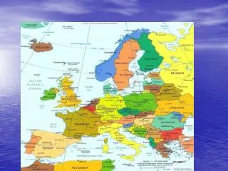
The Geography & Peoples of Europe. Adapted from Ms. Susan M. Pojer Horace Greeley High School Chappaqua, NY. Europe’s Latitude v. U.S. Former Soviet Region Compared in Latitude & Area with the United States. Satellite View of Europe. 3,800 square miles. R E G I O N S.

E N D
The Geography & Peoples of Europe Adapted from Ms. Susan M. Pojer Horace Greeley High School Chappaqua, NY
Former Soviet Region Compared in Latitude & Area with the United States
Europe: APeninsula of Peninsulas? OR A Peninsula of Asia?
Northern Peninsulas Scandinavian Peninsula Jutland Peninsula
Southern Peninsulas CrimeanPeninsula Iberian Peninsula Italian Peninsula Balkan Peninsula
Peninsulas Scandinavian Pen. JutlandPen. Crimean Pen. Italian Pen. Balkan Pen. Iberian Pen.
Bodies of Water ArcticOcean AtlanticOcean North Sea Baltic Sea English Channel CaspianSea Bay ofBiscay BlackSea DardanellesStrait Adriatic Sea AegeanSea TyrrhenianSea Strait ofGibraltar Mediterranean Sea
The Mediterranean Sea Strait of Gibraltar & the“Pillars of Hercules” 2,400 miles long & 1,000 miles wide “Crossroads of 3 Continents”
Rivers Volga R. Don R. Thames R. Elbe R. Vistula R. Oder R. Rhine R. Dnieper R. Seine R. Loire R. Danube R. Po R. Tagus R. Tiber R. Ebro R.
The Danube River 1770 miles
The Danube River Where Buda & Pest Meet Biking along the Danube Flows through the 12 countries of Germany, Austria, Slovakia, Hungary, Serbia, Croatia, Bosnia and Herzegovina, Slovenia, Bulgaria, Romania, and the Ukraine.
The Volga River It’s the longest river in Europe --> 2,300 miles.
The Volga River The river is so polluted that the sturgeon catch has been decreased by 60%.
Capitals on the Rivers Paris, right bank of the Seine London on the Thames Prague on the Vltava Budapest on the Danube
Capitals on the Rivers Moscow on the Moscow River Berlin on the Spree Rome on the Tiber Vienna on the Danube
Answer: They are Europe’s lifeline!
Moutains&Peaks Ural Mts. Carpathian Mts. Caucasus Mts. Alps Mts. Pyrennes Mts. Dinaric Alps Apennines Mts. Mt. Vesuvius ^ Mt. Olympus ^ Mt. Etna ^
Elevation Urals Caucasus Pyrennes Carpathians Alps Apennines
The Alps The Alps cover most of Switzerland, Austria, andparts of Italy and France.
Mt. Blanc in the Alps It’s the highest mountain in the Alps: 15,771 feet.
The Caucasus Mountains The origin of the word Caucasian.
Transylvaniain the Carpathian Mountains Home of VladTepeš, theDrakul(“Count Dracula”)
Ural Mountains: “The Great Divide” 1500 miles It divides the European and Asian sections of Russia.
Siberian Lowlands Plains Northern European Plain Steppes
The BENELUX Countries • Belgium • Netherlands • Luxembourg
Plateaus Meseta
ArcticOcean Completed Map Siberian Lowlands Ural Mts. Scandinavian Pen. AtlanticOcean Jutland Pen. Volga R. North Sea Baltic Sea Don R. Northern European Plain Thames R. Elbe R. Vistula R. English Channel Oder R. Rhine R. Steppes Dnieper R. Seine R. Carpathian Mts. CaspianSea Loire R. Caucasus Mts. Bay ofBiscay Alps Mts. Crimean Pen. Danube R. Po R. Pyrennes Mts. Italian Pen. Dinaric Alps Balkan Pen. BlackSea Tagus R. DardanellesStrait Apennines Mts. Tiber R. Iberian Pen. Adriatic Sea Mt. Vesuvius ^ Ebro R. Anatolean Pen. Mt. Olympus ^ AegeanSea TyrrhenianSea Strait ofGibraltar Mt. Etna ^ Peloponnesian Pen.
Norwegian Fjords Glaciers cut deep valleys in the ocean during the Ice Age.
Reykjavik, Iceland:“The Youngest Oldest Country” • Volcanoes • Hot Springs • Geysers
Mediterranean Islands The are generally rugged & mountainous. The Mediterranean Sea is so pollutedthat it will take 1000 years to clean up. Sardinia Cyprus Malta
Mt. Etna, Sicily an active volcano
Mt. Vesuvius, Italy Pompeii, 79 CE Herculaneum, 79 CE 1944 eruption
Eastern Europe
Siberia --> Permafrost The average temperatures of January vary from 0 to -50°C and in July from 1 to 25°C. 150,000,000 population. aformer “gulag” Soviet prison camp