Download
1 / 41
410 likes | 512 Vues
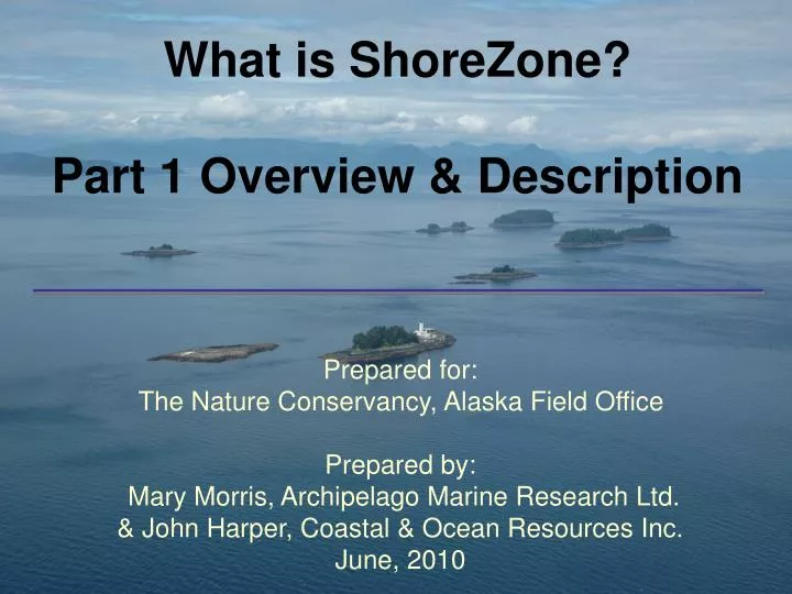
What is ShoreZone? Part 1 Overview & Description. Prepared for: The Nature Conservancy, Alaska Field Office Prepared by: Mary Morris, Archipelago Marine Research Ltd. & John Harper, Coastal & Ocean Resources Inc. June, 2010. Acknowledgements. Thank you!

E N D
What is ShoreZone? Part 1 Overview & Description • Prepared for: • The Nature Conservancy, Alaska Field Office • Prepared by: • Mary Morris, Archipelago Marine Research Ltd. • & John Harper, Coastal & Ocean Resources Inc. • June, 2010
Acknowledgements Thank you! Alaska Department of Fish & Game & The Nature Conservancy for providing the funding for this project
Part 1. Outline • Introduction to ShoreZone • Overview of ShoreZone methodology • Examples of observed and derived attributes • Example of mapped data
Key Contacts for Team ShoreZone • NOAA • Cindy Hartmann Moore (NOAA Fisheries, Juneau) • Mandy Lindeberg (NOAA Alaska Fisheries Science Center, at Lena Point, Juneau) • Steve Lewis (NOAA Fisheries, Juneau) & lead for the NOAA ShoreZone website and database distribution • The Nature Conservancy • Laura Baker (Juneau) • Alaska Department of Natural Resources • David Gann (Juneau) • Cook Inlet Citizens Advisory Council • Susan Saupe (Anchorage/Kenai)
Alaska Department of Environmental Conservation Alaska Department of Fish and Game Alaska Department of Natural Resources Alaska Ocean Observatory System Alyeska Pipeline Service Company Archipelago Marine Research Ltd. Coastal and Ocean Resources Inc. Coastwise Services Cook Inlet Regional Citizens Advisory Council Exxon Valdez Oil Spill Trustee Council Kachemak Bay National Research Reserve Minerals Management Services, Coastal Impact Assistance Program National Park Service NOAA National Marine Fisheries Service, Alaska Region and Alaska Fisheries Science Center North Pacific Research Board Prince William Sound Regional Citizens Advisory Council Prince William Sound Science Center Royal Caribbean Cruise Lines, Ocean Fund The Skaggs Foundation The Gordon and Betty Moore Foundation Sitka Tribe of Alaska Southeast Alaska Petroleum Resources Organization The Nature Conservancy US Coast Guard USDA Forest Service US Fish and Wildlife Service University of Alaska Fairbanks University of Alaska Southeast ShoreZone Alaska Partners
A Partnership that Works ! The ShoreZone Alaska team was the recipient of the 2009 Coastal America Spirit Award The national award is for “action-oriented, results-driven collaboration process dedicated to restoring and preserving coastal ecosystems and addressing critical environmental issues.”
What is ShoreZone? ShoreZone is a coastal habitat mapping system that characterizes physical and biological resources of the shoreline. ShoreZone features: • georeferencedimagery • georeferenced data • searchable database
What is ShoreZone? Standardized Coastal Mapping System wave exposure geomorphology sediment texture intertidal/subtidal biota supratidal biota man-made features
Where is ShoreZone? ShoreZone includes: • all ~ 5,000 km Washington • all ~ 40,000 km British Columbia • ~ 45,000 km Alaska (in progress; 59%) Almost 100,000 km of contiguous coastline has been mapped – from the Columbia River mouth to Bristol Bay, Alaska.
ShoreZone Method:Coastal Imagery • Mapping is based on video and still imagery: • - low-altitude flights of < 200m • zero tides or lower • oblique camera view- spatially-referenced
How is ShoreZone mapped? from imagery to maps with database
Recorded trackline provides reference position to videography and photos Barrier Islands, south Prince of WalesIsland
ShoreZone Method: Digital Shoreline Trackline and imagery are used to segment digital shoreline into along-shore units: GPS flight trackline recorded at1-second intervals:
688 690 687 689
Upper Beachface Cobble-pebble over sand Beach Berm Pebble over sand Lower Beachface Boulder-cobble-pebble over sand Low-tide Terrace Sand-mud
dune grass rockweed eelgrass soft browns
Attributes for the whole unit Attributes within across-shore of the unit
Biobands in ShoreZone A bioband is species assemblage with a characteristic colour and across-shore elevation. Splash zone lichen (VER) Barnacle (BAR) Blue mussel (BMU) Dark brown kelps (CHB) Islet, Kenai Fjords National Park
Saltmarsh Black lichen on boulders Blue Mussels on boulders Rockweed Green algae Barnacles Red Algae Eelgrass …across-shore zonation Northwest Prince of Wales Island
Biological Wave Exposure • derived from the combination of biobands present in the unit. HIGH energy Very exposed Exposed Semi-exposed Semi-protected Protected Very Protected LOW energy Souhwest of Sitka
Protected A characteristic assemblage of biobands and associated indicator species define each wave exposure category Sitka, AK area
Exposed Sitka, AK area
What biobands are recorded in ShoreZone? • salt marsh • intertidal algae • mussels • understory kelps • eelgrass • canopy kelps and more . . . .
2,532 km or 45% Distribution of Eelgrass in Prince William Sound
Perry Island Eelgrass (1:54,000)
Perry Island Eelgrass (1:10,000) (>50%)
Derived Attributes in ShoreZone • biological wave exposure • coastal class • habitat class • oil residence index
N Haida Gwaii Oil Residence Index derived from: the interaction of substrate permeability & wave energy
Exposed ORI = days to WEEKS Sitka, AK area
Protected ORI = MONTHS to Years Sitka, AK area
Habitat Suitability Development Siting Essential Fish Habitat Planning and Response ShoreZone Applications:A Spatial Framework for Coastal Habitat Management
Summary of ShoreZone Overview • based on low-tide imagery • a digital, georeferenced, searchable dataset of geomorphic and biological attributes. • imagery is web-posted, along with summary data tables and maps
Key Contacts • ShoreZone NOAA website at: • www.alaskafisheries.noaa.gov/habitat/shorezone/szintro.htm • the NOAA ShoreZone website & database distribution: • Steve Lewis (NOAA Fisheries, Juneau) • steve.lewis@noaa.gov (907) 586-7858 • contact at The Nature Conservancy: • Laura Baker (TNC Juneau field office) • lbaker@tnc.org(907) 586-8623