Download
1 / 30
300 likes | 407 Vues
Inundation. Frank’s Dump West - New Year’s Eve 2005 8.9 ft tides; 40mph westerly winds Photo: Mark Taylor. Erosion. Hayward Marsh - New Year’s Eve 2005 8.9 ft tides; 40mph westerly winds Photo: Mark Taylor. Functions. Urban Habitat Storm drainage Land fill

E N D
Inundation Frank’s Dump West - New Year’s Eve 20058.9 ft tides; 40mph westerly winds Photo: Mark Taylor
Erosion Hayward Marsh - New Year’s Eve 20058.9 ft tides; 40mph westerly winds Photo: Mark Taylor
Functions • Urban • Habitat • Storm drainage • Land fill • Wastewater • Utility corridors • Trails
Functions Railroad • Urban • Habitat • Storm drainage • Land fill • Sewage treatment • Utility corridors • Trails PGE Cable EBDA line HP Gas Bay trail
Realign Rapid landward movement increases as sea level rises
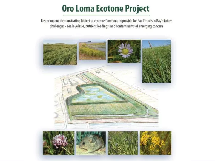
Examples of remnant native lowland (alluvial) grassland and sedge-rush meadow stands in lowlands bordering the Bay.
Upland Ecotone Treated Wastewater and Stormwater Overflow Wave Attenuation Seepage Rapid landward movement increases as sea level rises FreshwaterSwale Mudflat Tidal Marsh Brackish Marsh
Upland Ecotone ::: Hargreaves Associates :::
2047 Main Breaches High marsh/transitional habitat/buffer Break up levee
Overflow Wave Attenuation Seepage Rapid landward movement increases as sea level rises FreshwaterSwale Mudflat Tidal Marsh Brackish Marsh Demonstration Project • to measure wave attenuation over a tidal marsh and mudflat.
Overflow Wave Attenuation Seepage Rapid landward movement increases as sea level rises FreshwaterSwale Mudflat Tidal Marsh Brackish Marsh Demonstration Project • to create historic transitional habitat; • to create buffers to sea level rise; • to polish discharge by subsurface seepage.
An Adaptation Strategy? 0ft 1ft 2ft 3ft 4ft 5ft Existing levees Enhance existing wetlands, realign levees Terraced levees Terraced brackish levee Realign functions Realign functions Threshold Lead Time Effective Decision
Functions Railroad • Urban • Habitat • Storm drainage • Land fill • Sewage treatment • Utility corridors • Trails PGE Cable EBDA line HP Gas Bay trail