Download

1 / 12
120 likes | 123 Vues
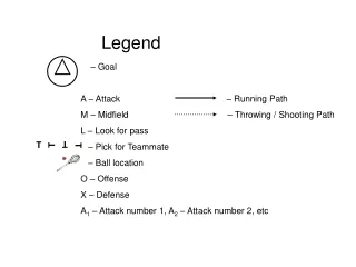
GLC2000 is a land cover classification approach that does not have fixed legends or class names. Land cover is described using classifiers and attributes, and the level of detail depends on available remote sensing data and information sources.

E N D
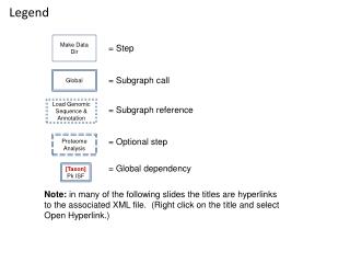
GLC2000 GLOBAL LEGEND GLC 2000 – “FIRST RESULTS” WORKSHOP JRC – Ispra, 18-22 March 2002
GLC land cover classification approach • No fixed legend and no fixed class names • Land cover described by classifiers and attributes (of vegetation / non-vegetation) • at detail possible - using the FAO LCCS standards & software • Detail of class description at a given geographical level depends on the • information obtainable from Remote Sensing (VEGETATION) • capability to map a class consistently • auxiliary map or information sources • Different legends or classes can be generated by grouping of classifiers and attributes • Compatibility at higher levels by grouping of classifiers and attributes
Arguments for this approach • the user is not forced to squeeze a regional / local class in a predefined global class name or legend >>e.g. forest > 60 percent tree cover • regional or sub-regional maps can be produced with legends and class names which meet the needs at this level >>e.g. detailed steppe and desert classes, detailed boreal forest types • direct links are possible to the national scale or field observations - if these are also coded with LCCS • legends can be adapted to specific purposes at the same geographical level : >>e.g. desertification monitoring, forest cover assessment, carbon stock inventory, … • >> enlarge the potential applications and user group
Minimum set of required classifiers • Objective of GLC2000: • Global land cover classification • uniform • consistent • comparable across regions • DEFINITION OF A MINIMUM SET OF REQUIRED CLASSIFIERS • mandatory for describing vegetation cover classes
Example for a general class: ‘Cropland’ (terrestrial) ‘Cultivated and Managed Terrestrial Areas’ no further classifiers obligatory as ‘Minimum’
based on SPOT VGT added ancillary data based SPOT VGT or ancillary data Example for more detailed requirements: ‘Natural vegetation’ (terrestrial) Note: In case of missing ancillary information on additional sparse layers the classifier ‘layering’ could be dropped.
e.g. regional /non-mandatory mandatory for global level TREE LAYER Evergreen Broadleaved Height 3-7m Elevation 1500-3000 Trees Closed (100-40%) Code: 2xxxx / A10//A12 E1 D1 B7 P3 A3 GRASS LAYER Herbaceous Closed (100-65%) Second layer Tree cover Sparse (5-15) Code: 2xxxx / A2 A10//A12 F2 D1 F2 Code: 2xxxx / A3 E1 Code: 2xxxx / Evergreen Forests: Vegetation with woody components: A3 F2 D1 Definition of a class by dominant life form with classifiers and attributes Definition of legend and classes depending on geographical level and purpose
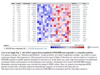
14. 1. Tree Cover closed, broadleaved, evergreen (LCCS >65% and >40-65% tree cover, tree height >3m ) Herbaceous Cover , closed-open 2. 15. Tree Cover closed, broadleaved, deciduous Herbaceous Cover, closed-open with sparse trees or sparse shrubs 16. 3. Tree Cover closed, needleleaved, evergreen Sparse Herbaceous or sparse shrub cover 17. 4. Lichens & Mosses Tree Cover closed, needleleaved, deciduous 5. 18. Tree Cover closed, mixed phenology or leaf type Regularly flooded shrub and/or herbaceous cover 6. 19 Regularly flooded cover of lichens and mosses Tree Cover open, broadleaved, evergreen (LCCS 15-40% tree cover, tree height > 3m) 20. 7. Tree Cover open, broadleaved, deciduous Cultivated and managed areas, terrestrial 21 8. Tree Cover open, needleleaved, evergreen Cultivated aquatic or regularly flooded 22 9. Tree Cover open, needleleaved, deciduous Tree cover / Other natural vegetation 23 10. Tree Cover open, mixed phenology or leaf type Cropland / Natural vegetation 11. 24 Bare Areas Tree Cover, Regularly flooded, any type 25. 12. Water Bodies (natural & artificial) Shrub Cover, closed-open, evergreen (with or without sparse tree layer) 26. 13. Shrub Cover, closed-open, deciduous (with or without sparse tree layer) Snow and Ice (natural & artificial) 27 Artificial surfaces and associated areas Global aggregation scheme
14. 1. 2*& A3, A10,A11,A12, D1, E1, 2*& A2-5-6, A10-11-12-13 2. 15. 2*& A3, A10,A11,A12, D1, E2 2*& A2-5-6, F2, F5-6 2*& A3, A14-15-16 or 4*& A3, A16-17-18 16. 3. 2*& A3, A10,A11,A12, D2, E1 2*& A2-5-6, A14-15-16 or 2*& A4, A14-15-16 17. 4. 2*& A7-8-9 2*& A3, A10,A11,A12, D2, E2 5. 18. 2*& A3, A10,A11,A12, D1+// D2 or E1//E2 4*& A4, D1-2, E1-2, F2,F5 6. 19 4*& A2-5-6-8-9 or 4*&A7-10-11 2*& A3, A11+A13, D1, E1, 20. 7. 2*& A3, A11+A13, D1, E2 0*& A11 21 8. 2*& A3, A11+A13, D2, E1 0*& A23 22 9. 2*& A3, A11+A13, D2, E2 2*& A3 and A2-4-5-6 or C2, F2, F4-6 or /0004 or 4*& A3, A2-4-5-6-8-9 or /0004 23 10. 0*/ 2*& A2-3-4-5-6 or 0*/ 4*& A2-3-4-5-6-8-9 2*& A3, A11+A13, D1//D2 or E1//E2 11. 24 6* 4*& A3, A12-13-14-15 25. 12. 8*& A1 or 0*& B27 2*& A4, D1-2, E1 and optional F2,F5 26. 13. 2*& A4, D1-2, E2 and optional F2,F5 8*& A2-3 27 0*& B15 Significant LCCS codes and classifiers for extraction * to be checked / complemented
Issues to be addressed during the working groups • at global level: • changes at the global aggregation scheme only if absolutely required • can the regional classes be converted into the global level? • can the global aggregation level be consistently achieved? • at regional level: • more detailed cover classes possible / desired • can an agreement on a ‘regional legend’ be achieved? • proposed starting topic of first WG
Remarks to LCCS coding • Threshold between closed and open forests appears to be more appropriate at • 40% canopy cover: • Forest closed : LCCS class ‘closed 40% -100%’ + LCCS class “open 40-65%’ , • Forest open: LCCS class ‘open’ 15-40% Can the 40% threshold be achieved as it was not set in the initial requirements? Present version of LCCS does not allow ‘thematic mix’ of 2 classifiers in one step • a mixed unit needs to be defined with 2 sub-components User comment ‘//’ is required in order to differentiate a thematic from a spatial mix! User labels (names) should be assigned with regional / local class names • User comments in case a class does not meet global legend: • Example: Closed –open >>assigned to closed