Download
1 / 37
370 likes | 535 Vues
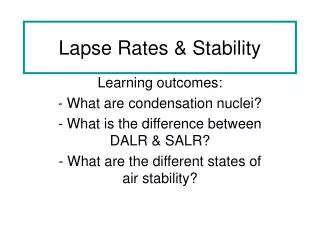
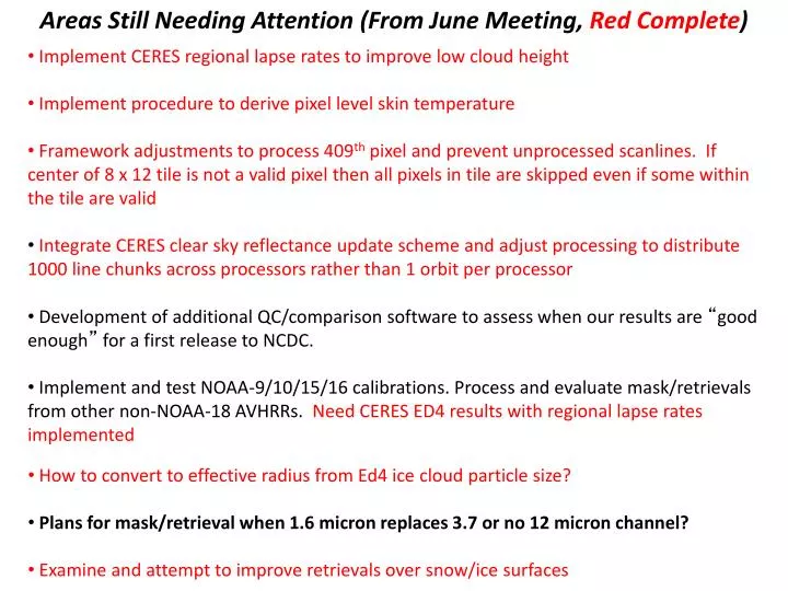
Areas Still Needing Attention (From June Meeting, Red Complete ). Implement CERES regional lapse rates to improve low cloud height Implement procedure to derive pixel level skin temperature

E N D
Areas Still Needing Attention (From June Meeting, Red Complete) • Implement CERES regional lapse rates to improve low cloud height • Implement procedure to derive pixel level skin temperature • Framework adjustments to process 409th pixel and prevent unprocessed scanlines. If center of 8 x 12 tile is not a valid pixel then all pixels in tile are skipped even if some within the tile are valid • Integrate CERES clear sky reflectance update scheme and adjust processing to distribute 1000 line chunks across processors rather than 1 orbit per processor • Development of additional QC/comparison software to assess when our results are “good enough” for a first release to NCDC. • Implement and test NOAA-9/10/15/16 calibrations. Process and evaluate mask/retrievals from other non-NOAA-18 AVHRRs. Need CERES ED4 results with regional lapse rates implemented • How to convert to effective radius from Ed4 ice cloud particle size? • Plans for mask/retrieval when 1.6 micron replaces 3.7 or no 12 micron channel? • Examine and attempt to improve retrievals over snow/ice surfaces
Other Accomplishments/Needs From Summer 2013 • Found that Yost thick cloud top height correction was not being called. P. Heck corrected retrieval code to enable this correction • Pixel level skin temperature retrieval methodology has been revamped to provide improved results • Other minor get_cloud edits per discussions between PM and PH (singlescat definition, use of “dif” parameter) • Found cases where stratocu cloud edges are being identified as ice phase, set up PH with AVHRR framework for debugging • Developed software for analyzing VZA dependence of AVHRR observations and retrieved parameters • Need to compute 24-hour mean surface temperature over land to use in regional lapse-rate code
AVHRR PROCESSING STEPS AND TIMING 2 DAYS OF ORBITS (28 ORBIT FILES) 125 MAX SIMULTANEOUS AMI JOBS 1) AVHRR Level 1B to NetCDF Conversion: Navigation/Parallax Correction, and Noise Filtering (if necessary, NOAA-6 to -14): 1 min 40 sec 2) Break orbits into 1000 scanline segments (Typical orbit: ~13000 scanlines), process with cloud retrieval code, write out 1000-line NetCDFs with 31 parameters: 14 min 20 sec 3) Merge 1000-line NetCDFs into 1 file for the entire orbit, add all necessary metadata such as max/min time max/min lat/lon: 1 min 4) Read in 2 days of full orbit NetCDFs, use adaptation of CERES Ed4 clear sky 0.65 um overhead albedo dynamic updating algorithm with MODIS maps as first-guess, generate 10-min resolution snow-free and snow-covered overhead albedo maps: 3 min 5 sec Total time: 20 min 5 sec * 15.5 2-day periods = ~312 mins = 5.2 hrs/month 1 Year = 2.6 days Total time without updating: 16 min * 15.5 2-day periods = 248 mins = 4.13 hrs/month
Dynamic map updated over 15 2-day periods, reflects conditions present on October 30
ICE/SNOW MAP COMPARISONS Western U.S.
ICE/SNOW MAP COMPARISONS Antartica CERES SNOW/ICE MAP MERRA SNOW/ICE MAP
AVHRR Pixel Level Skin Temperature Ben Scarino
October 2008 Pixel Skin Temperature: Original Method Take pixel from TOA down to surface using corr-k to “surface-leaving” IR temperature. Convert to skin temperature via Jin ocean emissivity: f(vza, wind speed (constant: 5 m/s))
October 2008 Pixel Skin Temperature: Ratio Method, 3x3 Cloud Filter MERRA skin temperature is brought to TOA via corr-k, where it is compared with observed TOA temperature, which has been gridded to the same resolution as MERRA. A correction for the surface, based on the TOA difference, is determined. That correction is applied to the MERRA skin temperature yielding a true skin temperature that is on the same resolution as MERRA. The ratio of TOA radiance to surface radiance is applied to pixel-level TOA radiance (for all pixels that fall within that grid box), thus yielding a pixel-level surface radiance. That pixel-level surface radiance is then converted to a pixel-level skin temperature. Filter out pixels with any adjacent cloud pixels
October 2008 Pixel Skin Temperature: Ratio Method, No Cloud Filter No adjacent cloud pixel filtering