Download
1 / 26
270 likes | 563 Vues
Multidimensional Data and GIS. Steve Kopp Nawajish Noman ESRI. Multidimensional Data. Data cube (3D) or hypercube (4D,5D…) Temperature varying with time Temperature varying with time and altitude. T. Y. X. Multidimensional Data. Time = 3. Time = 2. Time = 1. Multidimensional Data.

E N D
Multidimensional Data and GIS Steve Kopp Nawajish Noman ESRI
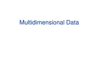
Multidimensional Data Data cube (3D) or hypercube (4D,5D…) • Temperature varying with time • Temperature varying with time and altitude T Y X
Multidimensional Data Time = 3 Time = 2 Time = 1
Multidimensional Data Time = 3 Time = 2 Time = 1
Multidimensional Data Time = 1 Time = 2 Data Cube Time = 3 Time Slices
Multidimensional Data Includes variation in (x,y,z,t)
What is NetCDF? NetCDF(network Common Data Form) A platform independent format for representing multi-dimensional array-orientated scientific data. Self Describing-a netCDF file includes information about the data it contains. Direct Access -a small subset of a large dataset may be accessed efficiently, without first reading through all the preceding data. Sharable -one writer and multiple readers may simultaneously access the same netCDF file. NetCDF is new to the GIS community but widely used by scientific communities for around many years
Why NetCDF? Most commonly used format in the oceanographic and atmospheric science for observational data and numerical modeling • The National Center for Atmospheric Research (NCAR) • University Corporation for Atmospheric Research (UCAR) NOAA's Climate Diagnostics Center (CDC) • Los Alamos National Laboratory (LANL) • The National Center for Supercomputing Applications • US Air Force and Navy • Atmospheric Research in Australia • Australia Defense • UK Hydrographic Office • NATO • ...
What is a NetCDF file? NetCDF is a binary file A NetCDF file consists of: Global Attributes: Describe the contents of the file Dimensions: Define the structure of the data (e.g Time, Depth, Latitude, Longitude) Variables: Holds the data in arrays shaped by Dimensions Variable Attributes: Describes the contents of each variable CDL (network Common Data form Language) description takes the following form netCDF name { dimensions: ... variables: ... data: ... }
netcdf mynetcdf { dimensions : X = 4 ; Y = 4 ; Time = UNLIMITED ; variables : float X ( X ) ; float Y ( Y ) ; int Time ( Time ) ; float Temperature ( Time , Y , X ) ; data : X = 10 , 20 , 30 , 40 ; Y = 110 , 120 , 130 , 140 ; Time = 31 , 59 , 90 ; } Storing Data in a netCDF File
netcdf mynetcdf { dimensions : X = 4 ; Y = 5 ; Time = UNLIMITED ; variables : float X ( X ) ; float Y ( Y ) ; int Time ( Time ) ; float Temperature ( Time , Y , X ) ; data : X = 10 , 20 , 30 , 40 ; Y = 110 , 120 , 130 , 140 ; Time = 31 , 59 , 90 ; Temperature = 111 , 211 , 311 , 411 ; } Storing Data in a netCDF File Time = 1 Y = 1 X = 1 to 4
netcdf mynetcdf { dimensions : X = 4 ; Y = 5 ; Time = UNLIMITED ; variables : float X ( X ) ; float Y ( Y ) ; int Time ( Time ) ; float Temperature ( Time , Y , X ) ; data : X = 10 , 20 , 30 , 40 ; Y = 110 , 120 , 130 , 140 ; Time = 31 , 59 , 90 ; Temperature = 111 , 211 , 311 , 411 , 121 , 221 , 321 , 421 , 131 , 231 , 331 , 431 , 141 , 241 , 341 , 441 ; } Storing Data in a netCDF File Time = 1 Y = 1 to 4 X = 1 to 4
netcdf mynetcdf { dimensions : X = 4 ; Y = 5 ; Time = UNLIMITED ; variables : float X ( X ) ; float Y ( Y ) ; int Time ( Time ) ; float Temperature ( Time , Y , X ) ; data : X = 10 , 20 , 30 , 40 ; Y = 110 , 120 , 130 , 140 ; Time = 31 , 59 , 90 ; Temperature = 111 , 211 , 311 , 411 , 121 , 221 , 321 , 421 , 131 , 231 , 331 , 431 , 141 , 241 , 341 , 441 , 112 , 212 , 312 , 412 , 122 , 222 , 322 , 422 , 132 , 232 , 332 , 432 , 142 , 242 , 342 , 442 , 113 , 213 , 313 , 413 , 123 , 223 , 323 , 423 , 133 , 233 , 333 , 433 , 143 , 243 , 343 , 443 ; } Storing Data in a netCDF File Time = 1 to 3 Y = 1 to 4 X = 1 to 4
NetCDF Data Sources • Community Climate Systems Model (CCSM) http://www.ccsm.ucar.edu, https://www.earthsystemgrid.org/ • The CCSM is fully-coupled, global climate model that provides state-of-the-art computer simulations of the Earth's past, present, and future climate states. • 100 yrs of climate change forecast data (2000-2099) • Control runs (1870-1999) and scenario runs • Temperature, precipitation flux, surface snow thickness, snowfall flux, cloud water content, etc. • Program for Climate Model Diagnosis and Intercomparison (PCMDI) http://www-pcmdi.llnl.gov/
NetCDF Data Sources • Vegetation and Ecosystem Modeling and Analysis Project (VEMAP) http://dataportal.ucar.edu/vemap/main.html • VEMAP was a large, collaborative, multi-agency program to simulate and understand ecosystem dynamics for the continental United States. • The VEMAP Data Portal is a central collection of files maintained and serviced by the NCAR Data Group • Climate data interval: Annual, monthly, and daily. • Data type: Historical and model results • Data: Temperature, irradiance, precipitation, humidity, incident solar radiation, vapor pressure, elevation, land area, vegetation, water holding capacity of soil, etc.
NetCDF Data Sources • British Atmospheric Data Center (BADC) http://badc.nerc.ac.uk/data/ • The role of the BADC is to assist UK atmospheric researchers to locate, access and interpret atmospheric data. • Many datasets are publicly available but datasets marked with key symbol have restricted access. • Datasets are organized by projects or organizations. • Climatology Interdisciplinary Data Collection (CIDC) has monthly means of over 70 Climate Parameters. • Met Office - Historical Central England Temperature Data has the monthly series, which begins in 1659, is the longest available instrumental record of temperature in the world. The daily series begins in 1772.
NetCDF Data Sources • National Oceanic & Atmospheric Administration (NOAA) • National Digital Forecast Database (NDFD) http://www.nws.noaa.gov/ndfd/ • Radar Integrated Display with Geospatial Element (RIDGE) http://www.srh.weather.gov/ridge/ • Precipitation Analysis http://www.srh.noaa.gov/rfcshare/precip_download.php • Climate Diagnostics Center http://www.cdc.noaa.gov/
NetCDF in ArcGIS • NetCDF data is accessed as • Raster • Feature • Table • Direct read (no scratch file) • Exports GIS data to netCDF
Gridded Data Raster Point Features
NetCDF Tools Toolbox: Multidimension Tools • Make NetCDF Raster Layer • Make NetCDF Feature Layer • Make NetCDF Table View • Raster to NetCDF • Feature to NetCDF • Table to NetCDF • Select by Dimension
Unidata NetCDF Filesby Cedric David • Catalog of Datasets • http://motherlode.ucar.edu:8080/thredds/catalog.html
NCEP NAM 12km Data • North American Model • Continuous grid over the continental US • Model runs are made at 06Z, 12Z, 18Z and 00Z • Forecasts every 3 hours out to 84 hours • Accessed With • OPENDAP • HTTPServer • WCS • NetcdfServer
Netcdf Server • Query for subset of data with Web Form • Download netCDF file
Query Via URL • Format documented at • http://motherlode.ucar.edu:8080/thredds/docs/NetcdfServer.html • Example: • http://motherlode.ucar.edu:8080/thredds/ncServer/model/NCEP/NAM/CONUS_12km/NAM_CONUS_12km_20060803_1800.grib2?grid=Total_precipitation&north=35&south=30&west=-90&east=-85&time_start=0.0&time_end=12.0 Data Type Bounding Box Start/End Time
NDFD Data Also Available • NWS National Digital Forecast Database • Gridded forecasts of sensible weather elements • 5km resolution over continental US • http://motherlode.ucar.edu:8080/thredds/catalog/model/NCEP/NDFD/CONUS_5km/catalog.html