Download

1 / 36
360 likes | 491 Vues
Understanding and Implementing Mapping and the US National Grid for Emergency Services. FEMA Higher Education Conference National Fire Academy. Talbot Brooks and Tom Terry. Learning Outcome Objectives. The importance of the US National Grid Enabling documents and supportive Federal agencies

E N D
Understanding and Implementing Mapping and the US National Grid for Emergency Services FEMA Higher Education Conference National Fire Academy Talbot Brooks and Tom Terry
Learning Outcome Objectives • The importance of the US National Grid • Enabling documents and supportive Federal agencies • Training objectives
“Who am I and why am I here?” • On 27 August 2005 I was tasked by the Bolivar County, MS Office of Emergency Management to find 2-4 people with solid computer skills to respond to the Mississippi Emergency Management Agency’s Emergency Operations Center in Jackson to help prepare written documents in support of the Hurricane Katrina operation. • We were soon tasked by MEMA to help provide map support using “that GSI stuff” for emergency responders and decision makers. • One of the very first products we were tasked with making was a map for search and rescue. The specifications were that it should contain streets with a 1-mile x 1-mile grid squares that could be uniquely addressed. The extent of the map should cover the three coastal counties (Jackson, Harrison, and Hancock).
So we made 250 of these and had them laminated and sent to the field…
Two days later… • Katrina had made landfall and the devastation exceeded most expectations • The search area was expanded to include Stone, Lincoln, George, and Pearl River counties. • I realized very quickly that I had screwed up. How was I to expand the map to encompass the new search area without altering the grid ID’s being used already?
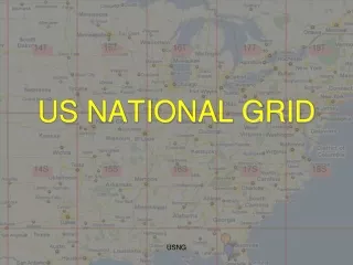
There is a better way… • It’s called the US National Grid and it would have greatly facilitated the solution to a lot of other problems: • Reporting of locations for evac, SAR activities, recoveries, etc… • It was already being used by 70,000 emergency responders – we call them the MILITARY • Comes complete with ready made grid boxes • Solves many other problems for emergency managers by allowing them to manage an event using maps to provide a common, spatially-based, operational framework.
Recommended solution using US National Grid to create 1km x 1km grid squares (contact DSU for procedure as it is involved and not straight forward – especially when working at zone junctions, but still preferable to any other lat/long or other grid system. The 1km x 1km grids may be used as the basis for 4km x 5km map pages (ideal for 8.5” x 11” printing). Because each page is based on USNG, each page may be assigned both a local page number and a universally unique and standardized USNG page number.
Sample USNG-based map Book page created using 4km x 5km assemblies of 1km x 1km USNG grids with layers for critical infra- structure. Background polygon layer is Electric utility Service Areas. Note that both a local page number and USNG page number are provided.
Similar map book page construct as shown in previous slide, but this one is using 1-m NAIP imagery. The blue marks around edge are NOT a dms graticule, but rather simply ticks every 30” for referencing purposes only (some refuse to acknowledge that USNG is the way to go and lat/long may be needed if coordinating agencies don’t “get it”)
Similar map book page construct as shown in previous slide, but this one is using 1:24,000 USGS topographic map as the background layer (Topo’s in our area have not been updated since the 1960’s)
Why not use Lat/long, state plane, 5’ grids, 2.5’ grids, UTM, etc…? • Latitude/longitude • Many different position reporting formats • Just how far is 1 minute of longitude anyway? • Ever tried to fix a position to within 10-m using a paper map and DMS? • But we have GPS!!! • Which works great when you’re not • In heavy weather • An urban environment • In a time of National crisis when the system gets shut off • And is fantastic if • Can remember the “-” sign when plotting longitudes • You like to lug around batteries • Enjoy watching football on 13” black and white TV’s • Can manage not to loose it while slogging through the mud but still can afford to give one to every person involved in a rescue. • But the#1 REASON IS THAT THE US NATIONAL GRID IS A NATIONAL STANDARD!
Other Critical Needs • Improved communication between emergency response community and geospatial professionals: • Geospatial professionals must better understand the organization, duties, and needs of emergency responders • Emergency responders must better understand the capabilities of geospatial information technologies • “Successful Response Starts With a Map” – National Academies of Science: http://www.nap.edu/catalog/11793.html#toc
Fundamentals of Mapping Support • Two audiences: • Decision Makers • Provide a “picture” (aka: a map) that describes the situation in a way that supports informed decision making • Responders • Navigation tools • Local decisions (where is…)
Take Home Message • Geospatial information technologies create the common, operational framework for managing an event • The US National Grid provides the common reference system for such a framework • This approach answers many of the criticisms, findings, and recommendations presented in Congress’ report on Katrina (“A National Still Unprepared”, multiple references, but most significantly Recommendation 51, pg 624)
Goals: Strategic • Better understand the mapping needs of emergency responders and decision makers • Provide supporting map education programs and services to emergency responders • Create an awareness of what is possible with mapping • Teach fundamental skills such as US National Grid • Create mapping products needed by communities for planning, prevention, response, and recovery phases of response in coordination with MS Institutes for Higher Learning
Goals: Tactical • Understand the US National Grid as demonstrated by an ability to: • Navigate using a map, compass, and map protractor with a USNG overlay • Be able to construct a map with a USNG overlay using ArcGIS • Be able to plot data using USNG • Communicate and interpret spatial information using the USNG
Mechanisms to explore • Local • 911 Commissions • County Government • Regional Response Teams • Fire, Police, EMS… • State • State-level offices of HS, Fire Marshall, etc.. • National • FEMA mitigation planning (may incorporated into your local plan or established as a project) • DHS critical infrastructure protection
Contact information Talbot Brooks, Director Center for Interdisciplinary GIT Delta State University Box 3325 Cleveland, MS 38733 (662) 846-4520 tbrooks@deltastate.edu Tom Terry HQ US Marine Corps Geospatial Information and Services 2 Navy Annex (Room 3129) Washington, DC 20380-1775 (703) 695-3118