Download
1 / 1
10 likes | 179 Vues
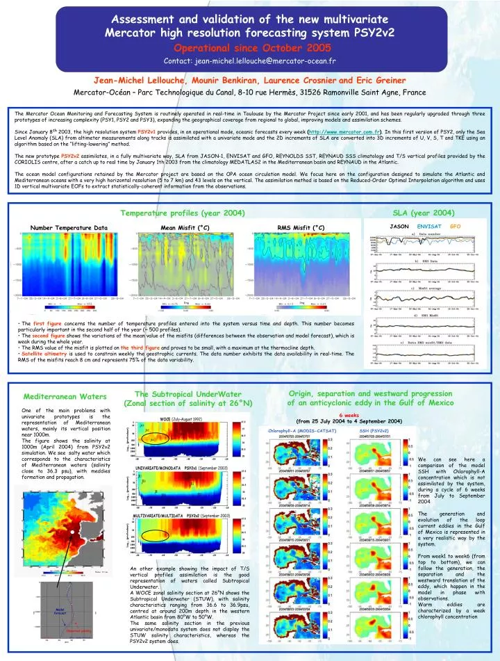
JASON ENVISAT GFO. Number Temperature Data. Mean Misfit (°C). RMS Misfit (°C). Model forecast. Observed salinity. Assessment and validation of the new multivariate Mercator high resolution forecasting system PSY2v2 Operational since October 2005.

E N D
JASON ENVISATGFO Number Temperature Data Mean Misfit (°C) RMS Misfit (°C) Model forecast Observed salinity Assessment and validation of the new multivariate Mercator high resolution forecasting system PSY2v2 Operational since October 2005 Contact: jean-michel.lellouche@mercator-ocean.fr Jean-Michel Lellouche, Mounir Benkiran, Laurence Crosnierand Eric Greiner Mercator-Océan – Parc Technologique du Canal, 8-10 rue Hermès, 31526 Ramonville Saint Agne, France The Mercator Ocean Monitoring and Forecasting System is routinely operated in real-time in Toulouse by the Mercator Project since early 2001, and has been regularly upgraded through three prototypes of increasing complexity (PSY1, PSY2 and PSY3), expanding the geographical coverage from regional to global, improving models and assimilation schemes. Since January 8th2003, the high resolution system PSY2v1 provides, in an operational mode, oceanic forecasts every week (http://www.mercator.com.fr).In this first version of PSY2, only the Sea Level Anomaly (SLA) from altimeter measurements along tracks is assimilated with a univariate mode and the 2D increments of SLA are converted into 3D increments of U, V, S, T and TKE using an algorithm based on the “lifting-lowering” method. The new prototype PSY2v2assimilates, in a fully multivariate way, SLA from JASON-1, ENVISAT and GFO, REYNOLDS SST, REYNAUD SSS climatology and T/S vertical profiles provided by the CORIOLIS centre, after a catch up to real time by January 1th 2003 from the climatology MEDATLAS2 in the Mediterranean basin and REYNAUD in the Atlantic. The ocean model configurations retained by the Mercator project are based on the OPA ocean circulation model. We focus here on the configuration designed to simulate the Atlantic and Mediterranean oceans with a very high horizontal resolution (5 to 7 km) and 43 levels on the vertical. The assimilation method is based on the Reduced-Order Optimal Interpolation algorithm and uses 1D vertical multivariate EOFs to extract statistically-coherent information from the observations. SLA (year 2004) Temperature profiles (year 2004) • The first figure concerns the number of temperature profiles entered into the system versus time and depth. This number becomes particularly important in the second half of the year (~ 500 profiles). • The second figure shows the variations of the mean value of the misfits (differences between the observation and model forecast), which is weak during the whole year. • The RMS value of the misfit is plotted on the third figure and proves to be small, with a maximum at the thermocline depth. • Satellite altimetry is used to constrain weekly the geostrophic currents. The data number exhibits the data availability in real-time. The RMS of the misfits reach 8 cm and represents 75% of the data variability. Origin, separation and westward progression of an anticyclonic eddyin the Gulf of Mexico The Subtropical UnderWater (Zonal section of salinity at 26°N) Mediterranean Waters One of the main problems with univariate prototypes is the representation of Mediterranean waters, mainly its vertical position near 1000m. The figure shows the salinity at 1000m (April 2004) from PSY2v2 simulation. We see salty water which corresponds to the characteristics of Mediterranean waters (salinity close to 36.3 psu), with meddies formation and propagation. 6 weeks (from 25 July 2004 to 4 September 2004) Chlorophyll-A (MODIS-CATSAT) SSH (PSY2v2) We can see here a comparison of the model SSH with Chlorophyll-A concentration which is not assimilated by the system, during a cycle of 6 weeks from July to September 2004 The generation and evolution of the loop current eddies in the Gulf of Mexico is represented in a very realistic way by the system. From week1 to week6 (from top to bottom), we can follow the generation, the separation and the westward translation of the eddy, which happen in the model in phase with observations. Warm eddies are characterized by a weak chlorophyll concentration An other example showing the impact of T/S vertical profiles assimilation is the good representation of waters called Subtropical Underwater. A WOCE zonal salinity section at 26°N shows the Subtropical Underwater (STUW), with salinity characteristics ranging from 36.6 to 36.9psu, centred at around 200m depth in the western Atlantic basin from 80°W to 50°W. The same salinity section in the previous univariate/monodata system does not display the STUW salinity characteristics, whereas the PSY2v2 system does.