Download
1 / 1
10 likes | 181 Vues
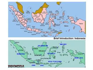
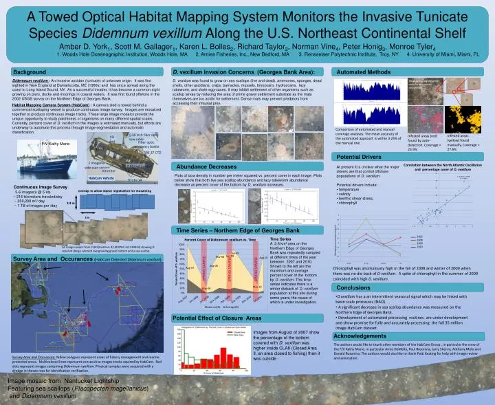
0.68 inch fiber optic tow cable. YSI unit. Fiber optic telemetry bottle. SBE 37 CTD. SPRING SAMPLE. SPRING SAMPLE. SPRING SAMPLE. 3/4 m. 2 Imagenix side scan sonars.

E N D
0.68 inch fiber optic tow cable YSI unit Fiber optic telemetry bottle SBE 37 CTD SPRING SAMPLE SPRING SAMPLE SPRING SAMPLE 3/4 m 2 Imagenix side scan sonars Amber D. York1, Scott M. Gallager1, Karen L. Bolles2, Richard Taylor3, Norman Vine4, Peter Honig3, Monroe Tyler4 overlap to allow object registration for mosaicing 2 Mpixelcamera 1. Woods Hole Oceanographic Institution, Woods Hole, MA 2. Arnies Fisheries, Inc., New Bedford, MA 3. Rensselaer Polytechnic Institute, Troy, NY 4. University of Miami, Miami, FL Altimiter HabCam Vehicle Strobe x4 Background • D.vexillum invasion Concerns (Georges Bank Area): Automated Methods 1m Didemnumvexillum: An invasive ascidan (tunicate) of unknown origin. It was first sighted in New England at Damariscotta, ME (1980s) and has since spread along the coast to Long Island Sound, NY. As a successful invader, it has become a common sight growing on piers, docks and moorings in coastal waters. It was first found offshore in the 2002 USGS survey on the Northern Edge of Georges Bank. • D. vexillumwas found to grow on sea scallops (live and dead), anemones, sponges, dead shells, other ascidians, crabs, barnacles, mussels, bryozoans ,hydrozoans, lacy tubeworm, and skate egg-cases. It may inhibit settlement of other organisms such as scallop larvae by reducing the area of prime gravel settlement substrate as the mats themselves are too acidic for settlement. Dense mats may prevent predators from accessing their infaunal prey. Detail of key bio-signature used for automated recognition Habitat Mapping Camera System (HabCam) : A camera sled is towed behind a commercial scalloping vessel to produce continuous image survey. Images are mosaiced together to produce continuous image tracks. These large image mosaics provide the unique opportunity to study patchiness of organisms on many different spatial scales. Currently, percent cover of D. vexillum in the images is estimated manually, but efforts are underway to automate this process through image segmentation and automatic classification. A Towed Optical Habitat Mapping System Monitors the Invasive Tunicate Species DidemnumvexillumAlong the U.S. Northeast Continental Shelf Comparison of automated and manual coverage analyses: The mean accuracy of the automated approach is within 3.24% of the manual one. Infested areas (yellow) found manually. Coverage = 27.6% Infested areas (red) found by auto-detection. Coverage = 23.9% Potential Drivers Correlation between the North Atlantic Oscillation and percentage cover of D. vexillum Abundance Decreases • At present it is unclear what the major drivers are that control offshore populations of D. vexillum. • Potential drivers include: • temperature • salinity • benthic shear stress, • chlorophyll • Plots of taxa density in number per meter squared vs. percent cover in each image. Plots below show that both live sea scallop abundance and lacy tubeworm abundance decrease as percent cover of the bottom by D. vexillum increases. F/V Kathy Marie Continuous Image Survey 5-6 images/s @ 5 kts ~ 216 kilometers traveled/day ~ 259,200 m2/ day ~ 1 TB of images per /day 2007 2008 2009 2010 Chlorophyll concentration (mg/m3) Time Series – Northern Edge of Georges Bank Time Series A 2.8 km2 area on the Northern Edge of Georges Bank was repeatedly sampled at different times of the year between 2007 and 2010. Shown to the left are the maximum and average percent cover of the bottom by D. vexillum. This time-series indicates there is a winter dieback of D. vexillumpopulation at this site during some years, the cause of which is under investigation. Chlorophyll was anomalously high in the fall of 2008 and winter of 2009 when there was no die back of D vexillum. A spike of chlorophyll in the summer of 2009 coincided with high D. vexillum. An image mosaic from CLAII (location: 42.003767,-67.330433) showing D. vexillum(beige colored) overgrowing gravel bottom and a sea scallop. Survey Area and Occurances(HabCam Detected Didemnumvexillum) Conclusions • D.vexillumhas a an intermittent seasonal signal which may be linked with basin scale processes (NAO). • A significant decrease in sea scallop abundance was measured on the Northern Edge of Georges Bank. • Development of automated processing routines are under development and show promise for fully and accurately processing the full 35 million image HabCam dataset. Potential Effect of Closure Areas Images from August of 2007 show the percentage of the bottom covered with D. vexillumwas higher inside CLAII (Closed Area II, an area closed to fishing) than it was outside . Acknowledgements The authors would like to thank other members of the HabCam Group , in particular the crew of the F/V Kathy Marie, in particular ArnieDeMello, Paul Rosonina, JarryShervo, Anthony Melo and Donald Rosonina. The authors would also like to thank Patti Keating for help with image review and annotation. Survey Area and Occuances: Yellow polygons represent areas of fishery management and marine protected areas. Multicolored lines represent consecutive images tracks aquired by HabCam. Red dots represent images containing Didemnumvexillum. Physical samples were acquired with a dredge in theseareas for identifcation verification. Image mosaic from Nantucket Lightship Featuring sea scallops (Placopectenmagellanicus) and Didemnumvexillum