Download
1 / 38
620 likes | 1.17k Vues
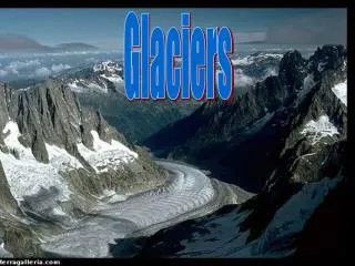
GLACIERS. http://en.wikipedia.org/wiki/Image%3AAletschgletscher_Panorama.jpg.

E N D
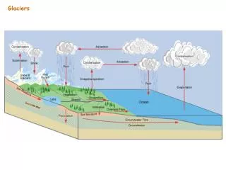
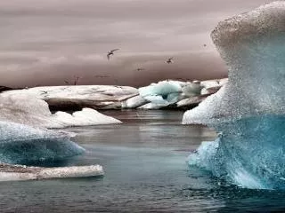
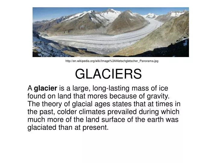
GLACIERS http://en.wikipedia.org/wiki/Image%3AAletschgletscher_Panorama.jpg A glacier is a large, long-lasting mass of ice found on land that mores because of gravity. The theory of glacial ages states that at times in the past, colder climates prevailed during which much more of the land surface of the earth was glaciated than at present.
WHERE TO GLACIERS COME FROM? • Formation and growth of glaciers -- Snow converts to glacier ice in somewhat the same way that sediment turns into a sedimentary rock and then into metamorphic rock. New fallen snow is characterized by air trapped between six-pointed snow flakes. Snow flakes settle by compaction under their own weight with the shape points of new formed snow destroyed and some of the air driven out.
WHERE TO GLACIERS COME FROM? • The compacted mass of granular snow is a transition between snow and glacier ice, called firn. More air is gradually driven out and the snow recrystallizes to form glacier ice with the texture of a metamorphic rock. As ice builds up it moves downward under the influence of gravity. The front of the glacier is wasted, or lost, by melting or breaking off (calving) to form icebergs.
http://en.wikipedia.org/wiki/Image%3AGlacial_ice_formation_LMB.pnghttp://en.wikipedia.org/wiki/Image%3AGlacial_ice_formation_LMB.png
TYPES OF GLACIERS • Alpine glaciation is found in mountainous regions, while continental glaciation exists where large part of a continent is covered by glacial ice. http://www.gpc.edu/~janderso/images/naglac.jpg • http://crystalproductions.com/catalog/images/CD3615.jpg
TYPES OF GLACIERS • A valley glacier is confined to a valley and flows from a higher to a lower elevation. An ice sheet is a mass of ice that is not restricted to a valley but covers a large area of land. Today ice sheets are only found in Greenland and in Antarctica. Recall that the polar regions of Mars are also covered by ice sheets. http://www.homepage.montana.edu/~geol445/hyperglac/morphology1/ContinentalIce.jpg http://www.swisseduc.ch/glaciers/earth_icy_planet/icons-02/01.jpg
Ice Caps • Ice caps are found in a few mountainous regions such as Norway and Chile and on islands in the Arctic Ocean. • Glacier Grey, southern end of Patagonian Ice Sheet, Chile http://fototrek-travel-photography.com/glaciergrey.htm http://cires.colorado.edu/science/groups/steffen/greenland/melt2002/melt1992-2002.jpg
GLACIAL MOVEMENT • Movement of glaciers -- The upper part of a glacier is the zone of accumulation where the glacier is perennially covered with snow. http://www.uwgb.edu/dutchs/graphic0/geomorph/longsect.gif
GLACIAL MOVEMENT • The lower part of the glacier is the zone of wastage . The lower edge of the glacier is the terminus. Valley glaciers move downslope under the influence of gravity and their own weight at a rate up to 15 meters a day. During movement there are three parts of the glacier: The zone of basal sliding; the zone of plastic flow; and the rigid zone. The rigid zone is brittle and sometimes is broken into crevasses. Ice sheets move with these three zones but often spread laterally rather than flow downslope.
GLACIAL MOVEMENT http://oz.plymouth.edu/~sci_ed/Turski/Courses/Earth_Science/Images/9.glacier.JPG
GLACIAL EROSION • A) Process of erosion:1) Pressure of moving glacial ice can pluck rock and debris up from the ground and carry it along. • 2) Also, once the debris is embedded in the ice, the moving ice acts as a rasp (sandpaper) that can grind away bedrock.
Consequences of Erosion: • Glacial erosion creates:* glacially polished surfaces* striations (scratches or grooves in bedrock) http://www.und.nodak.edu/instruct/mineral/101intro/slides/glaciers/
Consequences of Erosion: • C) Landforms formed by erosion:- In mountains (Alpine glaciation), you get distinctive landforms:* U-shaped valley: A valley, carved by a glacier, whose sides are very steep and whose floor is rounded, so that overall, the valley has a U-shape in profile; such valleys contrast with the V-shaped valleys carved by rivers)
GLACIATED TOPOGRAPHY http://oz.plymouth.edu/~sci_ed/Turski/Courses/Earth_Science/Images/8.glaciatedtopo.jpg
GLACIATED TOPOGRAPHY • * hanging valley: a side valley whose floor does not intersect the floor of the main valley; typically, a waterfall may spill out of the side valley) http://oz.plymouth.edu/~sci_ed/Turski/Courses/Earth_Science/Images/8.glaciatedtopo.jpg
GLACIATED TOPOGRAPHY *arete: a knife edge ridge between two valleys carved by glacier* cirque: a bowl-shaped depression formed at the head of an Alpine glacier. http://oz.plymouth.edu/~sci_ed/Turski/Courses/Earth_Science/Images/8.glaciatedtopo.jpg
A) Types of Sediment- Glaciers are, effectively, so viscous that they can carry sediment of any size (clay- to sand- to boulder-sized). Depositional Features of Glaciers erratic http://www.und.nodak.edu/instruct/mineral/101intro/slides/glaciers/
Depositional Features of Glaciers erratic http://www.und.nodak.edu/instruct/mineral/101intro/slides/glaciers/
- Till: At the toe, the glacier drops this sediment. The resulting unsorted debris (meaning, a mixture of grain sizes) is called till. (Note that sorting refers to the degree to which sediment has been winnowed so that it contains only one grain size. Well sorted sediment has only one grain size. Ice does not sort sediment because it is solid, and can carry material of any size. Glacial Till http://www.und.nodak.edu/instruct/mineral/101intro/slides/glaciers/
Glacial Till http://www.und.nodak.edu/instruct/mineral/101intro/slides/glaciers/
Depositional Features of Glaciers • - Outwash Gravel: Meltwater streams may wash through some of the till and sort out sand and gravel which it deposits in a wide plain to the front of the glacier. This moderately sorted sediment is called outwash, and the flat plane is called an outwash plain.
Outwash Delta http://www.und.nodak.edu/instruct/mineral/101intro/slides/glaciers/
Depositional Features of Glaciers • - Meltwater Lake Bed: In the quiet water of a meltwater lake, fine-grained clay can settle out to form mud. http://www.und.nodak.edu/instruct/mineral/101intro/slides/glaciers/
- Strong winds blow off of the glacier (because glacier cools the air and cold air moves to lower elevations at the front of the glacier). These winds pick up the fine sediment (silt and clay) and carry it beyond the outwash plain to where it is deposited. The resulting sediment is called loess. Loess
Depositional Landforms - Till can make up distinct landforms:* terminal moraine: if the nose position is fixed for a long time, a large pile develops. The glacier acts as a conveyor belt, bringing the sediment. If the glacier then retreats, the resulting ridge is called a terminal moraine.
Ground Moraine • * ground moraine: if an advancing glacier overrides the till pile, it smears it out on the ground surface, creating ground moraine. All the rock debris shown in the foreground of this photo constitutes ground moraine. The material was formerly beneath Grinnell Glacier. http://www.uwsp.edu/geo/faculty/lemke/alpine_glacial_glossary/landforms/groundmoraine.html
Esker http://www.und.nodak.edu/instruct/mineral/101intro/slides/glaciers/
Drumlin • * drumlin: sometimes the advancing ice molds the till into a streamlined hill (a drumlin). http://www.bennett.karoo.net/topics/glaciation.html
Drumlins http://www.und.nodak.edu/instruct/mineral/101intro/slides/glaciers/
What causes Ice Ages? • - Milankovitch, a Serbian astronomer, observed that variations in the earth's orbit, wobble of its axis, and inclination to the sun affects the amount of heat from solar radiation received by any particular portion of the earth.
What causes Ice Ages? • Eccentricity of the earth's orbit changes from a more circular to a more elliptical orbit on 100,000 year and 400,000 year cycles. Tilt of the earth's axis ranges from 21.5° to 24° on a cycle of every 41,000 years. The earth wobbles on its axis like a spinning top, making one revolution every 26,000 years.
What causes Ice Ages? • - Changes in the atmosphere may affect its ability to filter solar radiation because much of the solar energy reaching our planet is either reflected back out to space or absorbed by the atmosphere. Air bubbles in ancient glacial ice suggests that CO2 and CH4 are much higher in the atmosphere during interglacial periods than during glacial periods.
What causes Ice Ages? • - Changing of the positions of the continents during continental drift may place continental land masses in a position favorable for glaciation. The continents prevent warmer ocean water from circulating in polar regions and, hence, warming those regions. During the late Paleozoic a large continental land mass was located at the south pole.
What causes Ice Ages? • - Changes in circulation of sea water so that the warm Atlantic Ocean water can not freely circulate into the Arctic Ocean to warm the Arctic Ocean.
CITED • http://ijolite.geology.uiuc.edu/01FallClass/geo100/Lectures/SM_lecture26.html • http://en.wikipedia.org/wiki/Image%3AAletschgletscher_Panorama.jpg • http://en.wikipedia.org/wiki/Image%3AGlacial_ice_formation_LMB.png • http://www.geosc.psu.edu/~engelder/geosc20/lect14.html • http://www.ldeo.columbia.edu/edu/dees/ees/climate/slides/firn.gif • http://crystalproductions.com/catalog/images/CD3615.jpg • http://www.gpc.edu/~janderso/images/naglac.jpg • http://www.swisseduc.ch/glaciers/earth_icy_planet/icons-02/01.jpg • http://www.homepage.montana.edu/~geol445/hyperglac/morphology1/ContinentalIce.jpg • http://cires.colorado.edu/science/groups/steffen/greenland/melt2002/melt1992-2002.jpg • http://fototrek-travel-photography.com/glaciergrey.htm • http://www.uwgb.edu/dutchs/graphic0/geomorph/longsect.gif • http://oz.plymouth.edu/~sci_ed/Turski/Courses/Earth_Science/Images/8.glaciatedtopo.jpg • http://www.bennett.karoo.net/topics/glaciation.html • http://oz.plymouth.edu/~sci_ed/Turski/Courses/Earth_Science/Images/9.glacier.JPG • http://www.und.nodak.edu/instruct/mineral/101intro/slides/glaciers/ • http://www.sfu.ca/~jkoch/older_stuff/glacier%20glossary%20photos/loess.jpg • http://crevassezone.org/Photos/glacier_features.htm • http://www.uwsp.edu/geo/faculty/lemke/alpine_glacial_glossary/landforms/groundmoraine.html