Download
1 / 40
430 likes | 629 Vues
Archaeological Prospecting. What have you got? Where do you look? Where do you dig??? *Aerial photography *Electrical resistivity *Magnetometry *Ground penetrating radar (GPR) Electromagnetic induction Seismic probes (sonar) Gravimetry Gamma “radiography” IR emission imagery.

E N D
Archaeological Prospecting • What have you got? • Where do you look? • Where do you dig??? • *Aerial photography • *Electrical resistivity • *Magnetometry • *Ground penetrating radar (GPR) • Electromagnetic induction • Seismic probes (sonar) • Gravimetry • Gamma “radiography” • IR emission imagery Archaeology without a shovel
What are the clues? Shadowing
Soil marking Filled ditches- More moisture Roman roads- Paving-less moisture
Crop or vegetation marking Roman villa
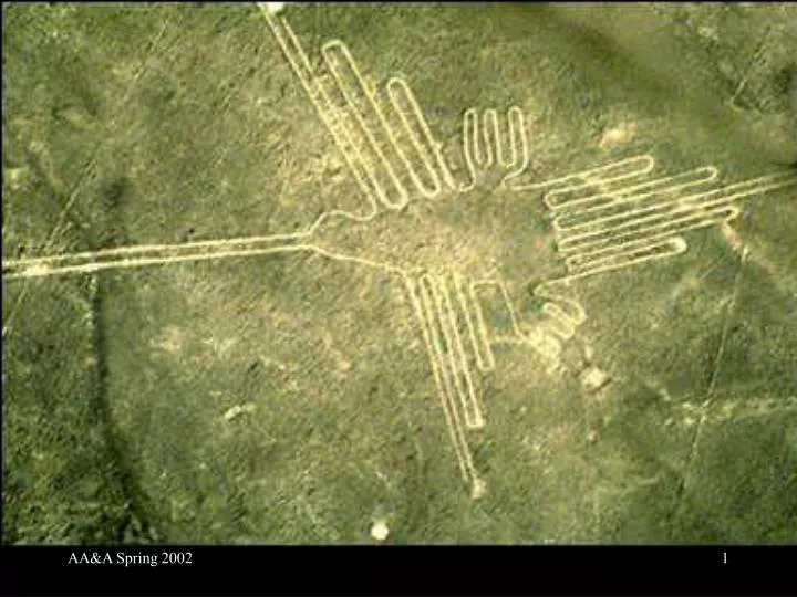
What is it? Nazca, Peru 200 BCE-600 CE Rocks removed to reveal lighter colored subsoil No rhyme or reason to complex array of lines photo
How to see without digging? • Want to use electrical conductivity: • Good insulators–dry brick, non-porous stone, glass, voids, dry soil • Good conductors–metals • In between (a tremendous range)–moist brick or soil, water • A way to measure conductivity of what’s underground??? Activities of man-----subsurface inhomogeneities
Where is it? _ _ _ + + +
How deep is it?? + + _ _ Sensitive to depths ~ 1.5 x separation
What do you see? =???? • Higher conductivity • Higher moisture content • More dissolved minerals • Metal artifacts • Lower conductivity • Lower moisture • Masonry • Voids
Conductivity data 20 meter grid
Magnetometry • How to look for magnetic materials? • Simplest of magnetometers is a compass
Magnetometry Signal Magnetometer Buried object Earth’s field Surface
Magnetic gradiometer Difference Signal Gradiometer difference Buried object Earth’s field Surface
Magnetometry Sense variations in Earth’s magnetic field need high sensitivity killed by fluctuations in time Solution: magnetic gradiometer pair of sensors look only at difference Sensitivity of the best (not the one illustrated): 10-8 of Earth’s field!
What do you see? Local variation in magnetism • Most obvious–iron artifacts • Recall colors of unglazed pottery • Red–hematite–Fe2O3–non-magnetic–“oxidized” • Black–magnetite–Fe3O4–magnetic–“reduced” • Magnetite containing soil • Soil replaced by stone masonry or red brick • Ditch or earthworks filled in by non-magnetic soil • Alignment of grains in clays disturbed by working • Soil disturbed (e.g., a grave) allowing oxygen access • Hematite containing soil • Reduction of iron in fire hearth • Destruction of building by major fire
Real data Conductivity Magnetometry
100meters Magnetic survey
Ground Penetrating Radar = GPR • How did we see below the surface of a painting? • Used Infra-red light to penetrate surface layer and see how it interacts with deeper layers. • Radar uses “light” of MUCH longer wavelength to penetrate soil.
Radar Distance = (travel time)/(twice velocity of light) 10 microseconds 1 mile 2 nanoseconds 1 foot
WE SUGGEST THAT YOU TURN OFF YOUR LAPTOPS AND WIRELESS DEVICES (INCLUDING CELL PHONES)