Download
1 / 1
10 likes | 181 Vues
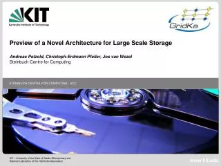
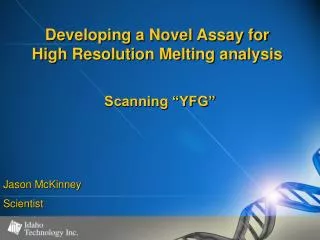
New Core from Well # 37-11 (Up is to the Right). 6621’. 6667’. Individual Stromatoporoid Coral. Chert stringer in dense limestone. SACROC Unit # 37-11 Image Log (Reverse Colors) with Ultraviolet Light Core Photography (Same Scale). Dynamic Image. Static Image. Core Photography.

E N D
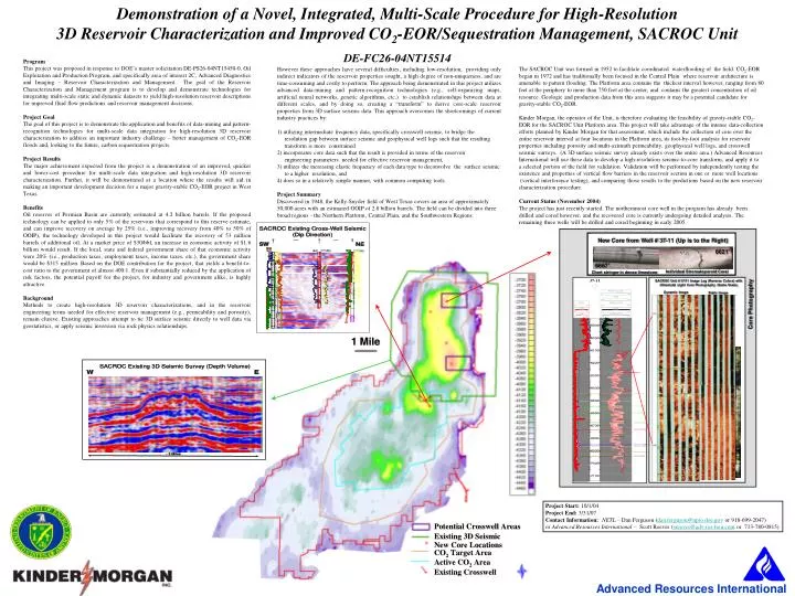
New Core from Well # 37-11 (Up is to the Right) 6621’ 6667’ Individual Stromatoporoid Coral Chert stringer in dense limestone SACROC Unit # 37-11 Image Log (Reverse Colors) with Ultraviolet Light Core Photography (Same Scale) Dynamic Image Static Image Core Photography Demonstration of a Novel, Integrated, Multi-Scale Procedure for High-Resolution 3D Reservoir Characterization and Improved CO2-EOR/Sequestration Management, SACROC Unit DE-FC26-04NT15514 Program This project was proposed in response to DOE’s master solicitation DE-PS26-04NT15450-0, Oil Exploration and Production Program, and specifically area of interest 2C, Advanced Diagnostics and Imaging – Reservoir Characterization and Management. The goal of the Reservoir Characterization and Management program is to develop and demonstrate technologies for integrating multi-scale static and dynamic datasets to yield high-resolution reservoir descriptions for improved fluid flow predictions and reservoir management decisions. Project Goal The goal of this project is to demonstrate the application and benefits of data-mining and pattern-recognition technologies for multi-scale data integration for high-resolution 3D reservoir characterization to address an important industry challenge – better management of CO2-EOR floods and, looking to the future, carbon sequestration projects. Project Results The major achievement expected from the project is a demonstration of an improved, quicker and lower-cost procedure for multi-scale data integration and high-resolution 3D reservoir characterization. Further, it will be demonstrated at a location where the results will aid in making an important development decision for a major gravity-stable CO2-EOR project in West Texas. Benefits Oil reserves of Permian Basin are currently estimated at 4.2 billion barrels. If the proposed technology can be applied to only 5% of the reservoirs that correspond to this reserve estimate, and can improve recovery on average by 25% (i.e., improving recovery from 40% to 50% of OOIP), the technology developed in this project would facilitate the recovery of 53 million barrels of additional oil. At a market price of $30/bbl, an increase in economic activity of $1.6 billion would result. If the local, state and federal government share of that economic activity were 20% (i.e., production taxes, employment taxes, income taxes, etc.), the government share would be $315 million. Based on the DOE contribution for the project, that yields a benefit-to-cost ratio to the government of almost 400:1. Even if substantially reduced by the application of risk factors, the potential payoff for the project, for industry and government alike, is highly attractive. Background Methods to create high-resolution 3D reservoir characterizations, and in the reservoir engineering terms needed for effective reservoir management (e.g., permeability and porosity), remain elusive. Existing approaches attempt to tie 3D surface seismic directly to well data via geostatistics, or apply seismic inversion via rock physics relationships. However these approaches have several difficulties, including low-resolution, providing only indirect indicators of the reservoir properties sought, a high degree of non-uniqueness, and are time-consuming and costly to perform. The approach being demonstrated in this project utilizes advanced data-mining and pattern-recognition technologies (e.g., self-organizing maps, artificial neural networks, genetic algorithms, etc.) to establish relationships between data at different scales, and by doing so, creating a “transform” to derive core-scale reservoir properties from 3D surface seismic data. This approach overcomes the shortcomings of current industry practices by: 1) utilizing intermediate frequency data, specifically crosswell seismic, to bridge the resolution gap between surface seismic and geophysical well logs such that the resulting transform is more constrained 2) incorporates core data such that the result is provided in terms of the reservoir engineering parameters needed for effective reservoir management, 3) utilizes the increasing elastic frequency of each data type to deconvolve the surface seismic to a higher resolution, and 4) does so in a relatively simple manner, with common computing tools. Project Summary Discovered in 1948, the Kelly-Snyder field of West Texas covers an area of approximately 50,000 acres with an estimated OOIP of 2.8 billion barrels. The field can be divided into three broad regions - the Northern Platform, Central Plain, and the Southwestern Regions. The SACROC Unit was formed in 1952 to facilitate coordinated waterflooding of the field. CO2-EOR began in 1972 and has traditionally been focused in the Central Plain where reservoir architecture is amenable to pattern flooding. The Platform area contains the thickest interval however, ranging from 80 feet at the periphery to more than 750 feet at the center, and contains the greatest concentration of oil resource. Geologic and production data from this area suggests it may be a potential candidate for gravity-stable CO2-EOR. Kinder Morgan, the operator of the Unit, is therefore evaluating the feasibility of gravity-stable CO2- EOR for the SACROC Unit Platform area. This project will take advantage of the intense data-collection efforts planned by Kinder Morgan for that assessment, which include the collection of core over the entire reservoir interval at four locations in the Platform area, its foot-by-foot analysis for reservoir properties including porosity and multi-azimuth permeability, geophysical well logs, and crosswell seismic surveys. (A 3D surface seismic survey already exists over the entire area.) Advanced Resources International will use these data to develop a high-resolution seismic-to-core transform, and apply it to a selected portion of the field for validation. Validation will be performed by independently testing the existence and properties of vertical flow barriers in the reservoir section in one or more well locations (vertical interference testing), and comparing those results to the predictions based on the new reservoir characterization procedure. Current Status (November 2004) The project has just recently started. The northernmost core well in the program has already been drilled and cored however, and the recovered core is currently undergoing detailed analysis. The remaining three wells will be drilled and cored beginning in early 2005. Project Start: 10/1/04 Project End: 3/31/07 Contact Information: NETL – Dan Ferguson (dan.ferguson@npto.doe.gov or 918-699-2047) or Advanced Resources International – Scott Reeves (sreeves@adv-res-hou.com or 713-780-0815)