Download
1 / 34
340 likes | 452 Vues
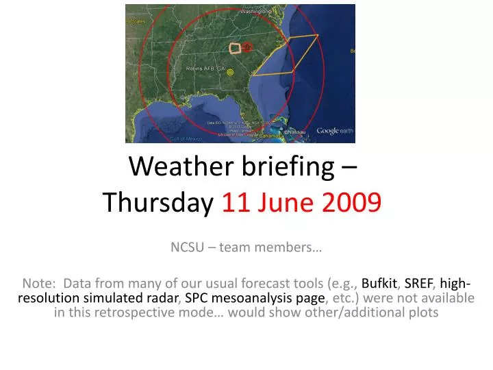
Weather briefing – Thursday 11 June 2009. NCSU – team members… Note: Data from many of our usual forecast tools (e.g., Bufkit , SREF , high-resolution simulated radar , SPC mesoanalysis page , etc.) were not available in this retrospective mode… would show other/additional plots.

E N D
Weather briefing – Thursday 11 June 2009 NCSU – team members… Note: Data from many of our usual forecast tools (e.g., Bufkit, SREF, high-resolution simulated radar, SPC mesoanalysis page, etc.) were not available in this retrospective mode… would show other/additional plots
Decisions/Things to Keep in Mind(as a forecaster) • Mission has to decide where to fly and what category of objective they’re fulfilling • The ER-2 needs 24 hours’ notice to fly • The ER-2 crew has strict rest policies • 12 hours after missions • 14 if mission is 8 hours • No more than 3 days without a down day • Calls need to be made about current missions with past and future missions in mind (for the above reasons) • The Citation should stay out of >35 dBZ • ER-2 takeoff no go if: • 25 knots maximum steady or 35 gusts regardless of dir. • 15 knot maximum crosswind • 1/4 mile minimum visibility • Lightning within 5 NM
Overview • Day -1 (W 10th): Stationary front to north, zonal flow aloft. Humid & unstable with moderate shear. Organized convective storms in afternoon, some severe • Day 0 (Th 11th): Instability and shear appear to have increased somewhat this morning, ingredients in place for organized convection. MCV to W this morning • Day 1 (F 12th): Weak front drops southward during the day, possibly enhanced, organized convection over area • Day 2 (Sa 13th) and beyond: Weak front to south of area, & weaker shear: Weaker, less organized convection. Potential for offshore convection with stalled front.
Day -1 (10 June) • MCS move east, passed to south of study area, dissipated over GA • New convection developed ahead of MCV, some severe (hail, wind) with these cells
Analysis, Day 0 (11 June) • Shear and instability have increased this morning (e.g,. ~2400 J/kg BNA at 12Z); MCV to west • One MCS to our north this morning as well, in addition to MCV to west • Diurnal heating possible this morning, further increasing severe threat • Timing: MCS/MCV over TN, moving east. Storms in area by 18 Z? Severe threat increased
SPC Day 1 outlook, valid 13Z 11th – 12Z 12th Primary: Hail, wind
Day 0 Forecast (11 June) • Organized convection, MCV to west will approach study area today; MCV in NAM initial condition • New convection could fire ahead of MCV currently over western TN (similar to yesterday) • Timing: Convective storms likely to develop between 17-20Z across study region (from west) • Aircraft threats: Lightning, hail @Robins afternoon, Convection (winds, hail, lightning) KAVL after 17Z
NAM 18-h fcst sounding, valid 18 Z 11 JuneKAVL WBZ: ~9200 ft Freezing level ~11,000 Sfc-6 km shear ~ 30 kt
Day 1 Forecast (Fri 12 June) • Weak cold front approaches, opportunity for organized convection ahead of front • Timing of weak front difficult to establish; merges with lee trough late in day (by 00Z Sat) • Now appears that passage will be around mid-day • Only weak drying, stabilization behind front, more so in wake of any organized convection that forms • As front stalls along coast, offshore convection potential increases early morning Sat and Sun (Day 2,3)
Days 2-3 (Sat, Sun) • Following weak cold front passage day 1, focus for convection shifts southward, and to offshore waters • Shear, instability will weaken, but sufficient instability to support diurnal orographic showers • Frontal boundary advances northward again towards study area, potential for more showers Days 2, 3 (Sat, Sun) • GFS shows MCV-type feature bringing strong storms to area Sun, but skeptical given convective origin of forcing in model forecast
Days 4+ • NW flow storms possible, shortwave passes north of area Saturday (model variability) • With ridge axis to west (aloft), NW flow regime becomes established • Longer term: Ensemble indicates very strong ridge developing over central US, study area in NW flow but dry with synoptic subsidence
84-h GFS 500-mb Z, SLP valid 12Z Sun 14 June Spurious system?