Download
1 / 13
140 likes | 333 Vues
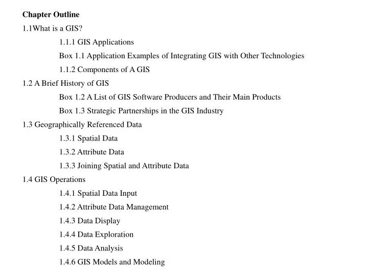
Chapter Outline 1.1What is a GIS? 1.1.1 GIS Applications Box 1.1 Application Examples of Integrating GIS with Other Technologies 1.1.2 Components of A GIS 1.2 A Brief History of GIS Box 1.2 A List of GIS Software Producers and Their Main Products

E N D
Chapter Outline 1.1What is a GIS? 1.1.1 GIS Applications Box 1.1 Application Examples of Integrating GIS with Other Technologies 1.1.2 Components of A GIS 1.2 A Brief History of GIS Box 1.2 A List of GIS Software Producers and Their Main Products Box 1.3 Strategic Partnerships in the GIS Industry 1.3 Geographically Referenced Data 1.3.1 Spatial Data 1.3.2 Attribute Data 1.3.3 Joining Spatial and Attribute Data 1.4 GIS Operations 1.4.1 Spatial Data Input 1.4.2 Attribute Data Management 1.4.3 Data Display 1.4.4 Data Exploration 1.4.5 Data Analysis 1.4.6 GIS Models and Modeling
1.5 Organization of This Book 1.6 Concepts and Practice
Applications: Introduction Task 1: Introduction to ArcCatalog, ArcMap, and ArcToolbox Task 2: Introduction to ArcInfo Workstation
An example of geographically referenced data. The street network on the left is based on a plane coordinate system. The box on the right describes a street segment in terms of the x- and y-coordinates of its end points and the attributes.
(col 2, row 2) (x1, y1) (x3, y3) (col 5, row 5) (x2, y2) (col 1, row7) The vector data model uses x-, y-coordinates to represent point features on the left, and the raster data model uses cells in a grid to represent point features on the right.
Spatial Data Vector Data Raster Data Non-topological Topological Higher-level Data Simple Data Dynamic Segmentation Regions TIN Data models for spatial data
Vector-based map overlay combines spatial data and attribute data from different maps to create the output.
Raster data analysis with multiple grids can take advantage of the fixed cell locations. Geometric intersection is not an issue with raster data.
U.S. Geological Survey http://www.usgs.gov/research/gis/title.html/ U.S. Forest Service http://www.fs.fed.us/fire/fire_new/tools_tech/ U.S. Department of Housing and Urban Development http://www.hud.gov/offices/cio/emaps/index.cfm National Institute of Justice http://www.ojp.usdoj.gov/nij/maps/ Federal Emergency Management Agency http://www.fema.gov/mit/tsd/mm_main.htm Larimer County, Colorado http://www.larimer.org/ Hertz Corporation http://www.hertz.com/
National Atlas of the United States http://www.nationalatlas.gov/ U.S. Census Bureau http://www.census.gov/geo/www/maps/CP_OnLineMapping.htm National Association of Realtors http://www.realtor.com/ Environmental Systems Research Institute (ESRI), Inc. http://www.esri.com/ Autodesk Inc. http://www3.autodesk.com/ Land Management Information Center at Minnesota Planning http://www.mnplan.state.mn.us/EPPL7 Baylor University, Texas http://www3.baylor.edu/grass/ Clark Labs http://www.clarklabs.org/
International Institute for Aerospace Survey and Earth Sciences, the Netherlandshttp://www.itc.nl/ilwis/ Manifold.net http://www.manifold.net/ MapInfo Corporation http://www.mapinfo.com/ ThinkSpace Inc. http://www.keigansystems.com/ Intergraph Corporation http://www.intergraph.com/ Bentley Systems, Inc. http://www2.bentley.com/ PCI Geomatics http://www.pcigeomatics.com/ TYDAC Inc. http://www.tydac.ch/
Caliper Corporation http://www.caliper.com/ Northwood Technologies Limited http://wnp.marconi.com/ Microsoft MapPoint http://www.microsoft.com/ Oracle http://www.oracle.com/ IBM Spatial DataBlade http://www-3.ibm.com/software/data/informix/blades/spatial/ GE-SmallWorld http://www.gepower.com/networksolutions/