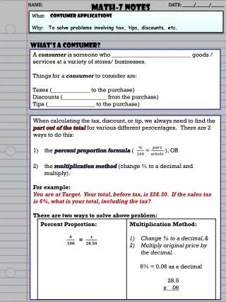
Download
1 / 15
150 likes | 287 Vues
Notes for Project 7 PVA Pro 9000. Problem Definition. The PVA Pro 9000 is a software application to support the estimation of acreage from aerial photographs or maps of geographical regions. The program provides the following functions:. Open an aerial photo or map image.

E N D
Notes for Project 7 PVA Pro 9000
Problem Definition The PVA Pro 9000 is a software application to support the estimation of acreage from aerial photographs or maps of geographical regions. The program provides the following functions: Open an aerial photo or map image. Set the scale of the image (e.g. pixels per unit distance). Permit the user to define a boundary around a region (e.g. a field). Compute the area contained in the defined boundary. Select a boundary for edit or deletion. Save the Image and the associated boundaries.
user clicks on image to draw a polygonal boundary
program uses boundary points and scale factor to compute an estimate of the acreage of the enclosed area.
Image, scale, and polygons will be saved so that they can be opened as a unit and edited. Include options for opening image only or to open a complete project session
Computing the Area of an Irregular Polygon Let me Google that for you... http://en.wikipedia.org/wiki/Polygon http://www.maa.org/pubs/Calc_articles/ma063.pdf
The PVA 9000 Project • This is a team project, which means that we will work on the problem definition and project design steps together in class. However, each of you will be responsible for encoding and debugging your own copy of the program. • Background • One of the tasks of a Property Valuation Assessor (PVA) is to estimate property values for the purpose of assessing taxes. This project is to develop a tool to support the PVA by providing a means of estimating acreage of land from maps and/or aerial images. • Program Overview • The PVA 9000 will permit the user to load and display aerial images and or maps of geographical regions and to identify regions of land by manually fitting a polygon to the land border. The area (in acres) of the enclosed land region will be computed based on a user-defined image scale. The program will provide the following functions: • Display - Open an aerial photo or map image. • Scale - Set the scale of the image (e.g. pixels per unit distance). • Boundary - Permit the user to define a boundary around a region (e.g. a field). • Area - Compute the area contained in the defined boundary. • Edit - Select a boundary for edit or deletion. • Save - Save the Image and the associated boundaries.
Display The user will be provided with a means to open and display a jpeg image or (map) of a geographical region. This image will be assumed to be a downward view in which the scale of distance is linear and constant across the entire image. The image will be assumed to be contained within the display region provided in the program.
Scale The user will be able to enter a scale in units of feet (or yards, meters, miles) per pixel. This scale value will be used to convert the boundary positions from pixels to map/image units and to convert the estimated area from square pixels to square map/image units. It is recommended that one of the methods provided to enter scale is by mouse clicks on a feature of known size on the image.
Boundary The user will be permitted to describe a polygonal boundary on the map/image using the mouse. This defined region must be a simple polygon (i.e. no overlapping lines).
Area The estimated area will be conputed using the Surveyor's Formula Where (xi,yi) is the ith point in the list of points defining the region boundary.
Edit The user will be permitted to edit the number and location of the boundary points in some manner. As this is likely to be the most challenging part of the project, we will include boundary editing in a later (optional) build.
Save/Load The user will be able to save a reference to an image along with any associated boundaries. In addition to opening an image for display, the user will then be permitted to load (open) a session which will be an image with its associated boundaries and scale factor. • Load/View Image • jpeg • Load Project • jpeg • boundary • scale same method for loading image should used with both options boundary and scale data can be stored in a text file.