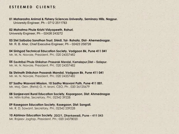
Download
1 / 26
270 likes | 370 Vues
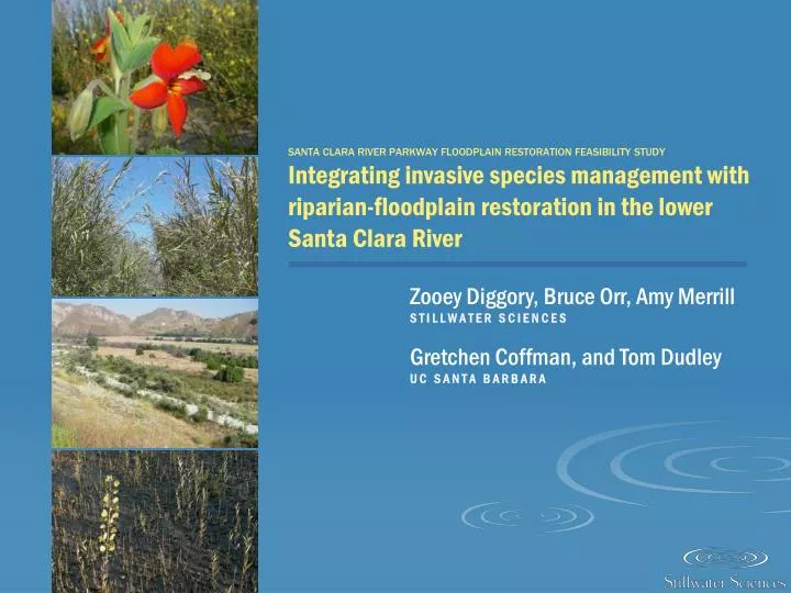
SANTA CLARA RIVER PARKWAY FLOODPLAIN RESTORATION FEASIBILITY STUDY Integrating invasive species management with riparian-floodplain restoration in the lower Santa Clara River. Zooey Diggory, Bruce Orr, Amy Merrill S T I L L W A T E R S C I E N C E S Gretchen Coffman, and Tom Dudley

E N D
SANTA CLARA RIVER PARKWAY FLOODPLAIN RESTORATION FEASIBILITY STUDYIntegrating invasive species management with riparian-floodplain restoration in the lower Santa Clara River Zooey Diggory, Bruce Orr, Amy Merrill S T I L L W A T E R S C I E N C E S Gretchen Coffman, and Tom Dudley U C S A N T A B A R B A R A
S A N T A C L A R A R I V E R W A T E R S H E D & A N A L Y S I S A R E A
P R E S E N T A T I O N OV E R V I E W • Historical Changes in Riparian Vegetation Extent • Influences on Riparian Vegetation Distribution & Composition • Vegetation-Process Linkages • Restoration & Invasive Species Removal Strategies
H I S T O R I C A L C H A N G E S I N R I P A R I A N V E G E T A T I O N E X T E N T • Literature Review • Flood Mapping
LITERATURE REVIEW • floodplain was as much as two miles wide in lowermost reaches(Simons, Li & Associates 1983) • dense, multi-stored stands of broadleaf trees that extended from a few to several miles wide(Roberts et al. 1980, Holland and Keil 1995, Boughton et al. 2006)
FLOOD MAPPING • Bare, partially- and highly-vegetated areas mapped after 6 major floods
I N F L U E N C E S O N R I P A R I A N V E G E T A T I O N D I S T R I B U T I O N & C O M P O S I T I O N • Riparian Vegetation Mapping • Vegetation Dynamics Analyses
RIPARIAN VEGETATION MAPPING • Accurate and current map of riparian vegetation (post-2005 flood)
VEGETATION DYNAMICS ANALYSIS • Canonical Correspondence Analysis (CCA)
V E G E T A T I O N – P R O C E S S L I N K A G E S • Climate • Flood Dynamics • Groundwater Availability • Floodplain Development • Invasion by Arundo Change background photo?
CLIMATE • Semi-arid, Mediterranean climate • Arid inland and moister, cooler coast
CLIMATE • Correlation between distance from river mouth and species distributions
FLOOD DYNAMICS • Vegetation reset after large floods, particularly in El Niño years FLOW pre-high flow JUNE 2002
FLOOD DYNAMICS • Vegetation reset after large floods, particularly in El Niño years FLOW high flow FEB 2005
FLOOD DYNAMICS • Vegetation reset after large floods, particularly in El Niño years FLOW post-high flow SEPT 2005
FLOOD DYNAMICS • Relative elevation and vegetation alliance distribution
GROUNDWATER AVAILABILITY • Gaining vs. losing reaches
GROUNDWATER AVAILABILITY • Vegetation alliances in gaining vs. losing groundwater reaches
FLOODPLAIN DEVELOPMENT • Agriculture • Levees and urban development
FLOODPLAIN DEVELOPMENT • 60 percent reduction in historical floodplain extent
INVASION BY ARUNDO • Replaces native vegetation • Alters ecosystem processes
RESTORATION & INVASIVE SPECIES REMOVAL STRATEGIES • Increase & Improve Floodplain Connectivity • Promote Revegetation via Natural Recruitment & Active Planting • Implement Strategic Actions to Control Arundo
INCREASE & IMPROVE FLOODPLAIN CONNECTIVITY • Acquisition & levee setbacks
PASSIVE & ACTIVE REVEGETATION • Allow natural recruitment in active floodplain • Focus active revegetation in areas not subject to frequent, resetting floods • Match target restored plant community types with site physical conditions 25-year floodplain (largest mapped flood on record) 1969 flood extent 500-year floodplain NATURAL RECRUITMENT (passive) PLANTING (active)
STRATEGIC ACTIONS TO CONTROL ARUNDO Remove arundo: • in an upstream to downstream direction • in fire-prone shrub lands • from watersheds and reaches with low nutrient levels • In the summer following major floods
ACKNOWLEDGEMENTS • Bruce Orr, Amy Merrill, Gretchen Coffman, & Tom Dudley • Coastal Conservancy & Santa Clara River Trustee Council • Bill Sears, Sebastian Araya, & Tami Cosio