Download

1 / 11
110 likes | 191 Vues
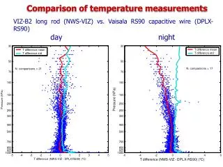
MMS - Ozonesonde Wind and Temperature Comparison during CR-AVE. T.P. Bui, J. Dean-Day, C. Chang, R. Castaneda NASA-Ames Research Center H. Voemel University of Colorado -- CIRES. Data Sources. Profiles of WB-57 MMS 1-Hz U, V, T and P during descent to Juan SantaMaria Int Airport

E N D
MMS - Ozonesonde Wind and Temperature Comparison during CR-AVE T.P. Bui, J. Dean-Day, C. Chang, R. Castaneda NASA-Ames Research Center H. Voemel University of Colorado -- CIRES
Data Sources • Profiles of WB-57 MMS 1-Hz U, V, T and P during descent to Juan SantaMaria Int Airport • Vaisala RS-80 radiosonde collected GPS position (latitude/longitude), T and P during Ozonesonde ascents from Heredia, Costa Rica • Heredia is in close proximity to Juan SantaMaria airport (10km distance separation) • Sondes launched within 1 hr of WB-57 takeoff or landing on 11 flights (10 descents, 1 ascent)
Data Specifications • Meteorological Measurement System: Static Pressure (+/- 0.3 mb) Static Temperature (+/- 0.3 K) Wind Velocity (+/- 1.0 m/s) • Vaisala RS-80 Radiosonde: Static Pressure (+/- 0.1 – 1.0 mb) Static Temperature (+/- 0.2 K) (Temperature corrected for radiation/ventilation effects) • Combined Uncertainty at same time/location: Temperature (+/- 0.5 K)
RS-80 Wind Calculation • Deriving Horizontal Winds from Sonde: GPS position (latitude/longitude/altitude) reported every 1 - 2 seconds during ascent to ~ 30km altitude Time rates of GPS latitude/longitude define U,V midway between GPS altitude levels U,V at reported levels estimated from spline interpolation of instantaneous U,V to each GPS altitude level Resulting U,V profiles were highly variable; Wind profiles subjected to simple vertical averaging to remove scales < 100m (approximately 20 sec during 5 m/s ascent)
Ideal Comparison • MMS and Sonde BOTH report GPS position: > Interpolate MMS data to ozone sonde GPS altitude > Minimum temporal/spatial separation • Ideal conditions for MMS–RS80 comparison: > All profiles are within 2 hours in time > Spatial separation < 60 km > In generally horizontal homogeneous environment (tropics)
Comparison Summary MMS warmer than RS-80 by 0.30 +/- 0.20K MMS Wind Velocity slightly lower (~ 0.65 m/s) but uncertainty is larger than mean differences • Pressure Difference is within RS-80 max error (1 mb) Sonde pressure is lower by 0.7 mb; larger uncertainty at lower altitudes scale with pressure.