Download
1 / 41
410 likes | 415 Vues
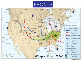
This refresher course provides an overview of the four main types of fronts (warm front, cold front, stationary front, occluded front) and their associated changes in temperature, dew point, wind direction, pressure, and cloudiness. It also explains the vertical structure of fronts and their connection to low-pressure systems. The course highlights the typical cloud progression before and after frontal passage, as well as the concept of occluded fronts. Additionally, it covers the evolution of cyclones and the energy source of midlatitude cyclones.

E N D
Fronts Atmospheric Sciences 101 Winter 2019
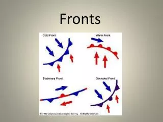
Refresher A front is a boundary between relatively uniform warm air and a zone in which temperatures cools rapidly
As a front passes there are changes in: • Temperature • Dew point • Wind direction • Pressure • Cloudiness
Cold Front • Slope 1:50, moves fast (20-30 mph), convection on leading edge
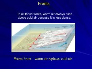
Warm Front • Smaller slope (1:200), slower (1—15 knots), more stratiform clouds
Stationary Front: similar structure to warm front, but without movement
There is a typical progression of clouds as cold and warm fronts approach and pass by • Cirrus • Cirrostratus • Altostratus • Nimbostratus • Cumulus after cold front
There is another type of front: the occluded front • But to understand this this front, you need to learn about the life cycle of fronts and cyclones.
For much of the 20th century the dominant paradigm for cyclone/frontal evolution has been the Norwegian Cyclone Model (Bergen School) Bjernkes, 1919
Stationary Polar Front Wave Forming on Polar Front
Wave Amplifies Occlusion as Cold Front Catches Up to Warm Front
During the 1930s-1950s we learned the relationship between cyclones and fronts and upper level flow • Upper troughs associated with surface lows. Usually lagging to the west. • Upper ridges asociated with surface highs. Usually lagging to the west.
Active fronts are generally in front of (east of) upper level troughs
https://atmos.washington.edu/~ovens/wxloop.cgi?h500_slp+/-168//https://atmos.washington.edu/~ovens/wxloop.cgi?h500_slp+/-168//
Warm (less dense) air rising and cold (more dense) air sinking lowers the center of gravity of the atmosphere • Like dropping a weight. • Potential energy (energy inherent in being aloft) is converted to kinetic energy (energy of moving air)
The conversion to kinetic energy is enhanced by having large differences of temperatures (large horizonal temperature gradients)
No accident that cyclones grow in regions of large temperature gradients