Download
1 / 12
120 likes | 309 Vues
Qilong Min. Bing Lin, Yongxiang Hu, Steven Harrah, and Dion Fralick Langley Research Center Hampton, VA 23681. Roland Lawrence. Session 3: Observing the Tropical Cyclone and its Environment. Radar Sea Level Pressure Remote Sensing for Improvements in Hurricane Predictions.

E N D
Qilong Min Bing Lin, Yongxiang Hu, Steven Harrah, and Dion Fralick Langley Research Center Hampton, VA 23681 Roland Lawrence Session 3: Observing the Tropical Cyclone and its Environment Radar Sea Level Pressure Remote Sensing for Improvements in Hurricane Predictions S.D.Harrah@LaRC.NASA.gov 757.864.1805 04 March 2008 Charleston, SC
Radar Sea Level Pressure Remote Sensing for Improvements in Hurricane Predictions OUTLINE • Need & Benefits • Measurement • Development Status • Conclusion
Off-Shore Air Pressure Measurements moored buoy dropsonde Radar Sea Level Pressure Remote Sensing for Improvements in Hurricane Predictions • Current operations require in situ measurement (few buoys & dropsonde)- sparse measurements in time and space- exposes air crews to a variety of dangers • Greatly improves hurricane forecasts(intensification and track) drift buoy Added Benefits of Remotely Sensed Measurements • Improved understanding of global pressure field (dynamics and interactions)- large area coverage & relatively rapid revisit intervals- lessen operational dangers & costs (long-term)
Radar Sea Level Pressure Remote Sensing for Improvements in Hurricane Predictions Example Benefits(Ivan’04 & Fran’97) no P data 998.7mb pressure variability: 882~1020mb with P data 951.5mb Control actual track with P data error: 1.5mb (47 mb change) 350 km landfall error reduced to < 100 km 72hr Forecasts
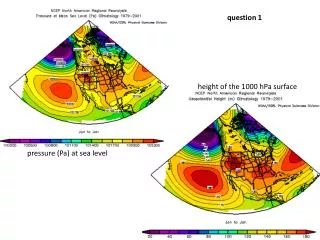
Example Benefits(Katrina) Radar Sea Level Pressure Remote Sensing for Improvements in Hurricane Predictions Aug 29 Key predictions in hurricane intensity and track are significantly improved using remotely sensed pressure measurements (p) compared to controlled models (c). Improvements in hurricane forecasts are demonstrated using press. measurements compared with control predictions and the observed track of Katrina.
Attenuation Radar Sea Level Pressure Remote Sensing for Improvements in Hurricane Predictions Measurement Concept Aircraft/Spacecraft-Based Q-Band (50-56GHz) Radar Oxygen in the atmosphereattenuates the transmitted signal – less at lower freq. and more at higher freq. Calibrated PRecw/o Attenuation PRec f or 1/l The amount of attenuation is directly related to barometric pressure and altitude. T/R Several (1-6), Narrow-Band (~100MHz) Signals Radar Attenuation by Oxygen Barometric Sensor (RAOBS)
Simulated Radar Results PR(l1) PR(l2) Radar Sea Level Pressure Remote Sensing for Improvements in Hurricane Predictions Most of the variability (shown here) is due to global atmospheric profile variations: temperature, water vapor, clouds, etc.
Radar Sea Level Pressure Remote Sensing for Improvements in Hurricane Predictions Ground Tests (LaRC) Projected Beamwidth Projected Beamwidth • Calibration Target • nearly spherical reflector • ~300m clear range • Calibration Target • nearly spherical reflector • ~300m clear range RAOBS PoC Instrument Installed on Mobile Radar Lab Radar Attenuation by Oxygen Barometric Sensor (RAOBS)
Supported by VDOT Radar Sea Level Pressure Remote Sensing for Improvements in Hurricane Predictions Ground Tests Measure Water NRCS Over Wide Inc. Ang. Support Satellite Design Varina-Enon Bridge I-295 South of Richmond, VA Approx. 150’ above James River
C E N T E R HELICOPTERS, INC. Radar Sea Level Pressure Remote Sensing for Improvements in Hurricane Predictions Flight Hardware Installation Bell 407 RAOBS PoC Instrument Internal Rack (VNA) Cable Routing Rail Mount Box Frame Antennas Flight Tests Q3 FY08 Port Side View
Radar Sea Level Pressure Remote Sensing for Improvements in Hurricane Predictions Satellite Concept RAOBS Torbit ~98 min Design Est.: Mass Power & DL Comm. TBD – FY’08 LEO (705 km) ±10o ~ ½ o 6 km 250 km
Radar Sea Level Pressure Remote Sensing for Improvements in Hurricane Predictions Conclusions • RAOBS Concept of Operation Instrument - Validated RAOBS Measurement Concept - Completed Ground Tests - Developed Flight Installation (awaiting FAA cert) - Looking for additional flight opportunities • RAOBS operational model shows significant improvements to our understanding of global pressure fields (dynamics and interactions) • Significant improvements to hurricane forecasts (intensification and track)- Improves forecast reliability- Increases warning times - Decreases social/economic impact • Beginning satellite design and subsystem definitions- Looking for collaborative partners / future satellite projects