Download
1 / 26

E N D
What Wind Is Wind is the movement of air relative to the Earth. It is named by the direction it comes from. Thus, a northwest wind blows from the northwest and moves toward the southeast. Blue Northers are the cold winds that sweep down the Great Plains and invade Texas from the north. Easterlies are winds that blow from the east and a Nor’Easter is a violent extratropical cyclone named for the direction of the wind in the sector of the storm where blizzard conditions are most likely. Wind speed is the distance the air moves divided by the time interval. Thus, for example, if air moves a distance of 100 meters in 50 seconds, the wind speed is 2 m/s (4 mph). Meteorologists use several different units for speed. The SI measure is m/s. The most common measure is miles per hour (mph) in the United States and kilometers per hour outside the USA. The wind barbs on weather maps use the mariner’s favorite measure, knots or nautical miles per hour. Nautical miles are measured by the Earth – 60 nautical miles = 1 of latitude (69 miles or 111 km). A wind speed of 60 knots means that the air would move 60 nautical miles or a distance equal to 1 of latitude in an hour.
When wind speed exceeds about 20 knots the wind can pick up dust and produce dust storms. Dust storms raged across the Great Plains during the droughts of the Dust Bowl in the early to mid 1930’s. Dust Storm Approaching Stratford, Texas in 1935
A dramatic dust storm (sometimes called a haboob) engulfing Phoenix, AZ on 05 July 2011
Power from the Winds Power from windmills is proportional to v3. Its theoretical maximum value is given by Betz’s Law For a windmill at sea level with blades 50 m long (A = pr2 7900 m2) in a wind speed of 10 ms-1 (20 mph) the maximum possible power is about 3 Megawatts.
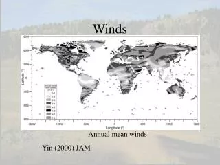
Wind Systems and the Scales of Motions The world’s winds can be classified according to their size or scale. 1. Planetary scale motions such as the Jet Stream, the Trade Winds and monsoons are about 10,000 km - roughly the Earth’s radius. 2. Synoptic scale phenomena are roughly 1000 km. They include moving high pressure areas, tropical and extratropical cyclones - the grand storm systems. 3. Mesoscale winds such as thunderstorms and sea breezes are between 4 and 400 km. 4. Microscale motions such as tornadoes are less than 4 km across. Earth’s rotation plays a major role in the character of planetary and synoptic scale motions, which have lifetimes of days. For smaller scale motions with a lifetime much shorter than a day, the impact of Earth’s rotation is small, so that it has almost no direct effect on microscale motions. Some wind systems defy easy classification. Both fronts and streaks in the jet stream are long, narrow zones that are synoptic scale in length but mesoscale in width.
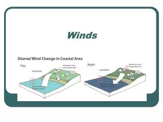
Driving the Winds: Sea Breeze by Day, Land Breeze by Night Temperature differences produce density and pressure differences that drive the winds. One classic example is the sea breeze and land breeze system. During the day, the land quickly gets hotter than the sea and air rises over the land. Cooler air over the sea then blows in from the sea near the surface while after rising 500 or so meters the wind aloft blows from land to sea and sinks over the ocean to complete a circulation cell. At night the land gets colder than the sea so the direction of circulation reverses, but is generally weaker. The sea breeze typically penetrates 10 km or more inland.
Sea Breeze: Yucatan Peninsula 15 June 2005 1625 UTC 00 UTC 18 July 1998
Valley Breeze by Day, Mountain Breeze by Night During the day the sun heats the mountainsides. This heats the air right over the slopes more than the air at the same level over the valley. The warm, light air then slides up the slopes and up the valley. If it rises enough it will produce cumulus or even cumulonimbus clouds over the summits while over the valley the cooler air sinks, making the sky clear. At night the mountainsides radiate heat to space and cool. This chills the air above the slopes, which then slides down the slopes and down the valley, often in spurts. The sky clears over the summits and stratus or fog may form in the chilled air of the valleys. Cu Stratus, Fog
Fog fills the Imperial Valley of California 13 Jan 2004 This fog sometimes gets so thick that it does not burn off during the day but can persist for days on end. Lines in the fog are flow lines (click to highlight them) showing (humid) air blowing into the valley from the Pacific Ocean through the Golden Gate, just north of San Francisco (SFO). At the same time, snow covers the Sierra Nevada Mountains, which enclose the Valley on its Eastern side. Sinuous breaks in the snow identify narrow river valleys. SFO
Newton’s Laws of Motion govern the motions of all objects including air. Newton’s First Law of Motion If no force is exerted on an object, its velocity will not change. Newton’s Second Law of Motion: F = ma The force on an object equals its mass times its acceleration. The first law represents a fundamental change from the mistaken notion that the natural state of things is be still. Any object resists attempts to change its speed or its direction of motion. This resistance to change is called inertia. Speed is the distance traversed divided by the time interval. Velocityis speed in a particular direction. If the direction of a moving object changes, its velocity also changes, even if the speed remains constant. Acceleration is the change of velocity divided by the time interval. Objects accelerate when their speed or direction of motion changes. Run Program FREEFALL
Forces and their Accelerations Newton’s Second Law (F = ma) enables us to predict changes in motion (i. e., acceleration, a) provided we know the forces acting on air. The four primary forces on air (and water) and their resulting accelerations are, 1. Weight (Gravity), produces a downward acceleration, g = 10 m s-2 at the surface of the Earth. 2. The Pressure Gradient Force produces an acceleration, apgfrom a point of high pressure to a point of low pressure that is proportional to the pressure difference between the two points divided by the distance between the points 3. Friction (viscosity for fluids) produces an acceleration, af in the direction opposite the motion and is proportional to the speed of the wind or current. Friction acts to reduce all relative motions (e. g., shear). 4. The Coriolis Force (a consequence of Earth’s Rotation) produces an acceleration, acor to the right of the motion in the North Hemisphere, that is proportional to the speed of the wind or current (and to the sine of the latitude). Buoyancy is a residual force that results when density differences cause an imbalance of weight and pressure in air or any fluid.
Pressure differences accelerate air directly from high to low pressure. The motive force is called the pressure gradient force because it is proportional to the pressure gradient, the pressure difference between two points divided by the distance between the points.
Earth’s Rotation and the Coriolis Force Coriolis force accelerates moving objects to their right in the NH and to their left in the SH because the sense of Earth’s rotation is opposite in the two hemispheres.
Earth as a Coriosel: The cannon ball moves in a straight line, but curves relative to a viewer on the coriosel, who is turning to his left (counterclockwise) Run Program CORIOLIS
Combinations of the Forces Most air motions result from combinations of several forces. Some classical situations result from the balance of two or more forces. They include Hydrostatic balance Geostrophic wind Gradient wind Cyclostrophic wind Ekman Spiral 1. Hydrostatic Balance and Buoyancy The sky does not fall because the downward force of gravity almost exactly cancels the upward pressure gradient force. The hydrostatic equation expresses the balance and is more than 99% accurate in the atmosphere except for extreme cases such as tornadoes. When the atmosphere is not perfectly hydrostatic, the difference between the upward pressure gradient force and the force of gravity is the buoyancy force. A parcel or balloon x% less (more) dense than the surroundings will have an upward (downward) acceleration due to buoyancy x% that of gravity. Thus, a parcel 10% denser than the surroundings will accelerate downward at 1 m/s2 or 10% of g.
Archimedes' Principle: Any object, wholly or partly immersed in a fluid, is buoyed up by a force equal to the weight of the fluid displaced by the object. renvVg renv rparVg Hot air balloons were invented in China. Zhuge Liang (250 AD) used Kongming lanterns for military signaling. The first documented balloon flight in Europe was made on August 8, 1709, in the Portuguese Court in Lisbon using a small paper burning balloon built by Bartolomeu de Gusmão, a priest. The first recorded balloon flight with humans took place on October 19, 1783 in Annonay, France in a balloon built by the brothers Joseph-Michel and Jacques-Etienne Montgolfier, paper manufacturers.
2. The Geostrophic Wind Normally, water flows downhill--directly to low pressure. But water spinning in a pail, flows around the pail even though the water slopes down toward the center. Similarly, large-scale winds do not blow directly towards low pressure, but instead blow with low pressure to their left in the Northern Hemisphere and to their right in the Southern Hemisphere. Thus, If you stand with your back to the wind, then low pressure is on your left (in the Northern Hemisphere). This strange behavior of the large scale winds is called Buy’s Ballot’s Law after the Dutch meteorologist, Christopher Buys-Ballot. Above the atmospheric boundary layer (more than about 1 km above ground level) there is almost no friction, so low pressure is almost exactly 90 to the left of the wind. If, the wind also flows in a straight line at a steady pace there is no net acceleration and it is called the geostrophic wind. The geostrophic wind blows parallel to the isobars with low pressure exactly 90° to itsleft (right) in the North (South) Hemisphere. Only two forces act on the geostrophic wind. The pressure gradient force pulls wind toward low pressure. It is exactly cancelled by the Coriolis force, which pulls the wind to its right. The geostrophic wind represents a perfect balance between the pressure gradient force and the Coriolis force. The geostrophic wind speed is inversely proportional to the distance between isobars
1020 PG 1016 1024 COR Buys Ballot’s Law and the Geostrophic Wind The Forces: Pressure Gradient Force points towards Low Pressure; Coriolis Force points to the right of the wind (North Hemisphere). When there is no friction (at least 1 km above the ground) and the wind is steady, the two forces are equal and opposite so they cancel. The result: The Geostrophic Wind Buys Ballot’s Law: Stand with your back to the wind in the North Hemisphere and Low Pressure is on your left. Forecasting Application: If high level clouds such as cirrus move from left to right when your back is to the wind then low pressure is approaching.
The Geostrophic Wind and Constant Pressure Charts Weather above the ground is depicted using charts at constant pressure. Standard (mandatory) levels for constant pressure charts are 850, 700, 500, 300, 250, and 200 hPa (1 hPa = 100 Pascals). Constant pressure charts have hills and valleys that correspond to high and low pressure areas. All contain contour lines of height. Other contour lines include T (850), vertical velocity and RH (700), vorticity (500) and wind speed (300, 250, and 200). They are used because, 1. High and Low pressure areas are displayed as hills and valleys. 2. Wind speed is inversely proportional to the distance between contours. 3. Temperature patterns are free of compression effects. The next slide shows why highs appear as hills on constant pressure surfaces and relates the pressure surfaces to the geostrophic wind and to geostrophic currents. If sea level pressure is 1020 hPa at the center of a high pressure area, the 1000 hPa surface lies directly above the high center because p decreases with height. Lower pressure at sea level surrounds the high. If the pressure at sea level at some distance from the high pressure center is 1000 hPa, we can find the 3-dimensional 1000 hPa surface by connecting all points where pressure is 1000 hPa. This produces a dome-like surface that arches over the high and intersects sea level at the 1000 hPa isobar. To see how geostrophic winds and currents develop, release a ball on a constant p surface. As the ball slides down, the Coriolis force will deflect it to its right until it finally moves so that the surface’s downslope side is on its left. This explains why the Gulf Stream, doesn’t flood NYC even though sea level is more than 1 m higher at Bermuda!
Forecasting Temperature by Advection (Wind) Temperature changes over time when the air upwind is colder or warmer. This is seen on constant pressure charts when Isotherms (typically solid lines) cross Contours (typically dashed lines). Directions for making a 12 hour Temperature Forecast 1. Estimate average wind speed and direction upwind from forecast city. 3. Calculate distance air travels (each 5 knots = 1° latitude per 12 hours). 4. Pinpoint upwind source of air arriving at forecast city. 5. Future T at forecast city is current T at upwind source. Assumptions:No heating or cooling, no vertical motions, no change of wind. Problems:1: When the atmosphere is stable, rising air causes cooling.2: Weather systems also tend to move from west to east and change shape so that wind changes both speed and direction. In the drawing to the right, cold air in the Northwest (NW) moves to the SE while warm air in the SE moves toward the N. COLD The next slide shows how T changed as the snowstorm of 26-27 Dec 2010 moved up the East Coast of the USA. WARM
The Strange Tilt of Weather Systems Outside the tropics, it is often observed that highs and lows and troughs and ridges are not vertically aligned but tilt upward to the West. In fact, 1: Lows and troughs always tilt upward toward the coldest air. 2: Highs and ridges always tilt upward toward the warmest air. 3. Systems with symmetrical Temperature patterns do not tilt with height. L L COLD COLD COLD WARM WARM L L Note how the trough (red dashed lines on next slide) slopes up to the West (where air is much colder) for the major snowstorm of 26-27 December 2010.