Download
1 / 13
130 likes | 317 Vues
An Atmospheric Decision Aid for Directed Energy Applications. Robert P. d’Entremont and Gary B. Gustafson Satellite Meteorology Group Atmospheric and Environmental Research, Inc. Lexington, MA 02421-3126 LTC Jeffrey D. Cetola Missile Defense Agency Kirtland AFB, NM

E N D
An Atmospheric Decision Aid for Directed Energy Applications Robert P. d’Entremont and Gary B. GustafsonSatellite Meteorology Group Atmospheric and Environmental Research, Inc.Lexington, MA 02421-3126 LTC Jeffrey D. CetolaMissile Defense AgencyKirtland AFB, NM James T. BuntingAir Force Research LaboratoryHanscom AFB, MA
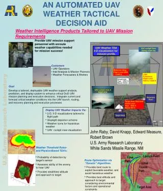
ADA - Objective • Characterize cloud impacts on Directed Energy Weapons • Emphasis on high-altitude clouds • Features: • Real-time cloud detection over theater-scale domains • Accurate cloud top/base height estimates • Simultaneous retrieval of bulk optical/microphysical properties (e.g., emissivity, optical depth, effective particle size) • Retrieve vertical distribution of key properties • Compute laser transmission along three-dimensional paths through the atmosphere. • Provide results in easy to interpret graphical form • Combine with independent optical turbulence models • Package as an interactive system on a portable laptop system • Suitable for remote deployment
Select satellite data time FTP current satellite data FTP bracketing MM5 data Uncompress calibrate geolocate Remap and time interpolate Cloud detection SDRs Cloud Mask Emissivity Optical Depth IWP/LWP Particle Size Cloud Top Cloud Base Cloud property retrieval ADA Overview GOES ground station Remote Data Analysis Center Time Interactive analysis/display
Satellite Data Requirements • Current support for geostationary satellites • Sensor data: VIS 0.6 μm, MWIR 3.9 μm, WV 6.7 μm, TIR 10.7 and 12 / 13.3 μm
Target Altitude Optical Path SourceAltitude Compute Transmission Along 3D Path • Define a region where target is expected to appear • Integrate transmission over conic surface covering estimated target location(s) • Optionally vary elevation angle to target • Display integrated transmission/optical depth at each point along set of possible paths to target Source
Current ADA Status • Cloud detection and retrieval software continuously operating on live data from GOES-10 and 12 • 15-minute updates processed at AER • super rapid-scan data processed when available • Available on AER web site (www.aer.com/cloud) • ADA laptop in beta test • Additional capabilities/features being developed • Introduce short-term advection forecast capability • Particle size retrievals independent of temperature • Deterministic cloud thickness (supporting RAOB data) • Expand comparison studies using DOE/ARM data • Modify algorithms to operate on polar-orbiting satellite data • Integrate turbulence metrics with cloud path transmission