Download
1 / 55
550 likes | 743 Vues
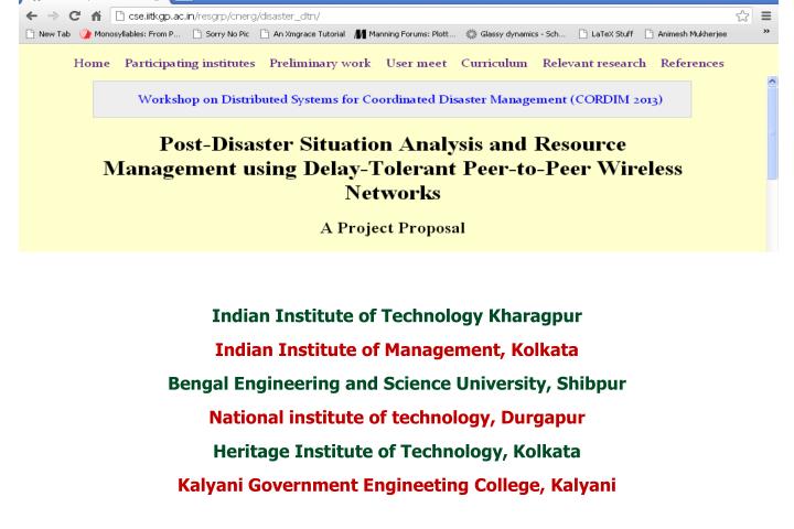
Indian Institute of Technology Kharagpur Indian Institute of Management, Kolkata Bengal Engineering and Science University, Shibpur National institute of technology, Durgapur Heritage Institute of Technology, Kolkata Kalyani Government Engineeting College, Kalyani. Personal Background.

E N D
Indian Institute of Technology Kharagpur Indian Institute of Management, Kolkata Bengal Engineering and Science University, Shibpur National institute of technology, Durgapur Heritage Institute of Technology, Kolkata Kalyani Government Engineeting College, Kalyani
Personal Background • Indian Scenario Disaster management…. (personal experience)
Scenario • User Meet
Advanced Country and Backward • Case study to bring out contrast and hopes
No comparison or mention of the recent Japan disaster (A.2) Lack of a detailed sketch of the architecture to be deployed (A.1, A.3) Absence of a precise problem definition (A.4-A.6), (B.1, B.2) Our connections with the disaster relief personnel are not clearly stated (C.1, A.9). Summary of criticisms
No cellular infrastructure We propose latency-aware ad-hoc network architecture SP – Shelter points MCS – Master control Station Four tier architecture Communication infrastructure (A.1 – A.3)
Tier - 1: Rescue personnel carrying smart phones that can form a DTN; exchange information among themselves through the DTN Tier -2: Message packets shall be unloaded into Throwboxes belonging to SPs Tier – 3: Communication among far apart Throwboxes shall be facilitated through Data Mules Tier – 4: One of the Throwboxes within a small group shall be elected as the center to communicate through Wi-Fi (Line-of-Sight) devices with other groups as well as with the outside world Communication infrastructure (A.1 – A.3)
TB TB Group Center Latency = 3hr. 20 mins Latency of 3hr 20 mins matures…. Group Center MCS Group 1 Group 2
[Saha 12] S. Saha, V. K. Shah, R. Verma, R. Mandal, S. Nandi,” Is It Worth Taking A Planned Approach To Design Ad Hoc Infrastructure For Post Disaster Communication?”, ACM MobiCom Workshop on Challenged Networks (CHANTS) 2012. Communication infrastructure (A.1 – A.3) Four Tier hybrid Architecture using DTN Nodes, ThrowBoxes(TBs), DataMules(DMs) and WiFi Towers(WTs)
Given a (i) initial disaster hit area map which can be realized as a graph G(V,E), where V= {set of ThrowBox (TB) at each shelter point} and E={set of pathways among those TB}. (ii) finite pool of resources and (iii) load (function of no of victims and size of an affected area which is under coverage of one Throwbox) -- what is the minimum achievable latency (L) such that almost 100 % packet delivery is ensured? Conversely for aforesaid graph with given (i) latency, and (ii) load -- what is the optimal number of network resources that are required to ensure almost 100 % of packet delivery? As disaster hit area may change with time it is also important to answer with existing network setup and given resource what is the minimum achievable latency with least/ tolerable movement of resources to ensure almost 100% of packet delivery? Designing the mixed-mode routing protocol lie in dealing with tradeoff between fairness and prioritized access, protocol inter-operability, authentication, universal user/device identity, group multicast, etc. Research problems: 4 tier architecture (A.5, B.1)
Our System Model Affected Area 24 KM MCS 20 KM
Required Resources for Satisfying 3hr 20 minutes & 2 hrs 40 Minutes Latency 2 hrs 40 mins latency 3 hrs 20 mins latency
Comparison between Planned & Random Placement with 3 hrs 20 minutes Latency Planned Approach Random Approach Time vs. Delivery Probability for Planned and Unplanned Approach
Topological change towards betterment with Time Keeping Same Latency Constraint Initial topology Improved Topology Degradation of delivery probability due to Deployment Overhead for topological changes Time vs. Delivery Probability with Low Load
Google Map Based User Interface for Network Resource Planning
Feeding Input Highlighting Activity Area and Variable Constraints are Fed
ThrowBox & Shelter Point Creation SP and TB are Drawn on Google Map using Google Map API
Determining Distance Finding out the Geographical and Geodesic Distance between TB’s for each Combination
Group Formation TB’s form various groups as per the Heuristic Approach Adopted & Wi-Fi Tower is placed on the Group Center
Finding Data Mule Trajectory Finding DM trajectory and the number of DM required for each group
Problem Definition Build an annotated people/resource map Approximate position of the victims and the resource situation shall be highlighted on a time-varying basis Location awareness
Solution Physical co-ordinates provided by smart-phones carried by rescue workers shall serve as anchor points Clever Crowd Sourcing to identify other users. Location awareness
Caveats GPS Constraints Many mobile phones (Give a snapshot of your phone) cannot do GPS localization without wireless connection Atmospheric Condition hinders GPS localization Mobility and Delay Delay in aggregating the data brings in accuracy as the user has already moved from the reported position Location awareness
Mobility induced error correction Movement is predominantly deterministic Landmark based localization Annotate the disaster prone area graph with landmarks Identify them as anchor points Location awarenessProposed methodology
In-built sensors of smart phones produce/identify anchor points Gyroscope, accelerometer – can sense turns/bumps on roads Relative humidity sensor – can sense the presence of a place like pond Barometric sensor / gravity sensor – can sense the different floors of a building Location awareness
Initial study: landmarks of the 2nd floor of the CSE Department, IIT Kharagpur • Phone : Samsung Galaxy S2 i9100G • Platform : Android 2.3.6 • App Used : SensoSaur
Swadhin CSE IIT Kgp 2nd Floor Plan Toilet Starting/Ending Pt.
Landmarks using GSM signal strength (Manual) Strongest (15-22) Weakest (7-12)
Landmarks using Wi-Fi (Manual) Linksys,Research,HWLAB,58.x AP Linksys,HWLAB,Research,Abhishek_PC Linksys,HWLAB,Research Linksys,HWLAB,Research,Abhishek_PC,58.x AP
Landmarks using light (Day) Highest Light Lowest Light Highest Light
Landmarks using light (Night) Bright (Tube Light) Dark (No Tube Light)
Good indicators of the situation of victims of man-made calamities – victims themselves can tweet about the extent of damage caused and the specific help required Recent studies show that 30% of tweets posted immediately after calamities contain situational information … But only 17% are credible Using online social media to gather authentic situational information (A.4)
Research questions Judge credibility of the tweets posted immediately after a calamity Retweets not a good metric since rumors might also get retweeted millions of times Proposed: identify authoritative experts on calamities Challenge – to discover such experts in Twitter Utilize knowledge of location of the person posting a tweet Analyze local flow patterns Sensor information can be coupled with tweets Using online social media to gather authentic situational information (A.4)
Example of rumors after Blasts in Mumbai http://blogs.wsj.com/indiarealtime/2011/07/15/mumbai-blasts-did-twitter-really-help/
Example of rumors after terrorist attack http://www.in.com/news/current-affairs/mumbai-blast-13th-and-on-kasabs-birthday-19724405-in-1.html
Examples of rumors after UK Riots http://www.guardian.co.uk/uk/interactive/2011/dec/07/london-riots-twitter
India and other developing countries are still not equipped with an organized post-disaster relief programme Japan enjoys State and private machineries, Huge economic power, A strong socio-cultural backbone to combat with post-disaster situation that is non-replicable in the context of India Japan use UAVs (unnamed aerial vehicles ) and under water robots to analyze post-disaster situation and fix damaged cables The economic strength of India does not allow of such an infrastructure and an alternative could be to use smart-phones (augmented with various sensors) to design low-cost (possibly not the best) solutions Comparison with relief measure Japanese earthquake
Works as good indicators of the situation of victims of man-made calamities – victims themselves can tweet about the extent of damage caused and the specific help required Recent studies show that 30% of tweets posted immediately after calamities contain important situational information Research questions – credibility of the tweets posted Retweets -- not a good metric since rumors might also get retweeted millions of times Online social media: Source of authentic situational information (A.4)
Rumors about disaster on the social media (Mumbai Blast) • http://blogs.wsj.com/indiarealtime/2011/07/15/mumbai-blasts-did-twitter-really-help/
Rumors about disaster on the social media (Mumbai Blast) http://www.in.com/news/current-affairs/mumbai-blast-13th-and-on-kasabs-birthday-19724405-in-1.html
Rumors about disaster on the social media (UK Riots) http://www.guardian.co.uk/uk/interactive/2011/dec/07/london-riots-twitter
Identify local authoritative experts – difficult to track since Twitter-like social media are full of celebrities that completely shadow the presence of these experts Challenge – to discover such experts Analyze local flow patterns Sensor information can be coupled with tweets Relevance of a tweet reporting a damage can be better judged if the location information of the person tweeting is available. Online social media: Source of authentic situational information (A.4)
India and other developing countries are still not equipped with an organized post-disaster relief programme Japan enjoys State and private machineries, Huge economic power, A strong socio-cultural backbone to combat with post-disaster situation that is non-replicable in the context of India Japan use UAVs (unnamed aerial vehicles ) and under water robots to analyze post-disaster situation and fix damaged cables The economic strength of India does not allow of such an infrastructure and an alternative could be to use smart-phones (augmented with various sensors) to design low-cost (possibly not the best) solutions Comparison with relief measure Japanese earthquake
A Secure Decentralized Disaster Management Information Network using Rapidly Deployable Wireless and Mobile Computing Technologies -- A DIT Funded project successfully accomplished by Prof. SomprakashBandyopadhyay (IIM Calcutta), Dr. Siuli Roy (HIT, Kolkata) and Mr. SujoySaha, NIT Durgapur Work on directional antenna, DIT funded projects on peer-to-peer networks, Vodafone funded projects on mobile communication networks (Prof. NiloyGanguly) Collaboration and management plan: Past Experience (Research)
Collaboration and management plan: Past Experience (Field work) The communication was setup among threeislandnear gosaba using 802.11 enabled with optilink devices configured in point to multipoint bridge with 15dbi antenna which was found to be able to cover near about 7 to 8 km range in line of sight. Using this link voice communication was established with NGOs as shown in figure.
IIT Kharagpur Comparison of infrastructure for disaster management after calamities in Japan, Pakistan, Haiti and India Information dissemination in DTN using bipartite networks Online social media for gathering situational updates (jointly with BESU Shibpur ) SensoSaur - Landmark based location tracking Collaborative download framework IIM Kolkata Collaboration and management plan: On-going work