Download
1 / 12
120 likes | 125 Vues
ATSR-2 and AATSR Validation with SISTeR. Tim Nightingale Rutherford Appleton Laboratory This work was funded by an EO enabling grant from the UK NERC and has been conducted in collaboration with Leicester University. Overview.

E N D
ATSR-2 and AATSR Validation with SISTeR Tim Nightingale Rutherford Appleton Laboratory This work was funded by an EO enabling grant from the UK NERC and has been conducted in collaboration with Leicester University ENVISAT Validation Workshop
Overview • A SISTeR radiometer was deployed on the RRS Charles Darwin as a part of the SCIPIO cruise, lead by Adrian New of the Southampton Oceanography Centre. • SCIPIO was a multidisciplinary investigation into the area surrounding the Mascarene Ridge, a chain of islands and seamounts between the Seychelles and Mauritius in the Indian Ocean. • Cruise activities included studies of the South Equatorial Current, regional bio-chemistry and large internal waves, and validation of the ATSR-2, AATSR and MERIS instruments. • SISTeR generated skin SST data sets to validate ATSR-2 at end of life and AATSR during its commissioning phase. • To date, no AATSR L1 or L2 data covering the SCIPIO cruise have been received at RAL – this presentation describes the validation measurements and their application to ATSR-2. ENVISAT Validation Workshop
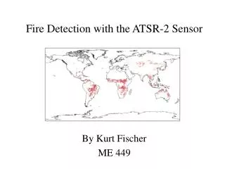
The RRS Charles Darwin ENVISAT Validation Workshop
SISTeR • SISTeR is a chopped, self-calibrating filter radiometer with infrared filters matching those in ATSR-2 and AATSR. • Near to ambient temperature and with the 10.8µm or 12.0µm filter, radiometric noise is approximately 30mK for a 0.8s sample and radiometric accuracy is of order 20mK. • SISTeR measures sea and sky radiances. ENVISAT Validation Workshop
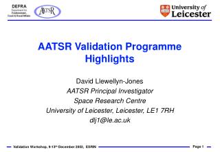
SISTeR Measurements • SISTeR was installed on the foremast platform of the RRS Charles Darwin. • Looked forward, about 45° from the ship’s centre line. • Views at 25° from nadir (sea) and 0°, 25° and 50° from zenith (sky). • Sea view to clear sea ahead of bow wave. • The 25° sky view is used to correct for reflected sky radiance in the sea view. • Skin SSTs are calculated with Planck’s equation from the corrected sea radiance. SISTeR installation on the foremast platform of the RRS Charles Darwin ENVISAT Validation Workshop
CD141 – SCIPIO • The RRS Charles Darwin departed Mahé, Seychelles on the 1st June 2002. • Made an intermediate port call at Mauritius. • Arrived in Mauritius on the 12th July 2002 (measurements finished on the previous day). • The Weather was often poor below 10°S – south-east trade winds brought rain and high seas. • There were seventeen AATSR and ATSR-2 overpasses, of which four are candidates for validation points • Auxiliary data include full met measurements, bulk SSTs, long and short wave fluxes and radiosonde profiles. The track of the RSS Charles Darwin for the SCIPIO cruise, showing the availability of SISTeR data (thickened line) and the positions of the seventeen ATSR-2 and AATSR overpasses ENVISAT Validation Workshop
SISTeR SSTs • SISTeR operated for approximately half of the cruise period (shut down for bad weather for the remaining time). • Most SISTeR skin SSTs fell between 24°C and 28°C. • The SISTeR calibration was checked before, during and after the cruise, against a CASOTS black body reference. There was no change to within experimental error (~5mK) despite degradation of the optical surfaces. SISTeR skin sea surface temperature record for the SCIPIO cruise ENVISAT Validation Workshop
Identfying Overpasses • Calculate time-varying unit vectors pointing to ship (GPS) and satellite (product file or reference orbit). • nship . nsat = cosQ • Closest approach when Q is smallest. • Look for local maxima of nship . nsat • Refine maxima by Newton-Rapheson iteration. • Sub-satellite point moves much faster than ship so the closest approach is very nearly across the satellite track. • Choose overpasses whereQ × Rearth < 256km. nship nsat Q ENVISAT Validation Workshop
ATSR-2 Data • There are significant problems with the geolocation of ATSR-2 products, particularly in the forward view, following the failure of the ERS-2 gyros in early 2001. • Absolute alignment of ATSR-2 images from the SCIPIO cruise using surface features is not possible, due to the lack of local land. • An ATSR-2 test processor (T360), incorporating attitude correction data (pitch and yaw only) derived from the ERS-2 scatterometer, has been used to generate SCIPIO ATSR-2 products. • There are still significant residual geolocation errors. • It may be possible to make further improvements to the location of the forward view by matching cloud outlines – the cloud base was generally low and parallax errors are likely to be small in comparison. ENVISAT Validation Workshop
ATSR-2 Data • ATSR-2 nadir (left) and forward 10.8µm gridded brightness temperature images for overpass 16 (red cross), geolocated with attitude correction files generated from the ERS-2 scatterometer. • Note the severe corrections to the forward view. ENVISAT Validation Workshop
ATSR-2 Data Summary Overpass 4 Overpass 6 Overpass 8 Overpass 16 ENVISAT Validation Workshop
Overpass SISTeR (± 1 hour) ATSR-2 Nadir (≤ 50km) ATSR-2 Dual (≤ 50km) 4 300.79K 300.82K 300.76K 6 301.27K 301.15K 301.07K 8 300.09K 300.36K 300.21K 16 299.00K 299.16K 299.01K Skin SST Comparison • All four overpasses at night. • Long time (1 hour) and large area (50km radius) averages taken about overpass time and position to try to ameliorate geolocation problems. • SISTeR SST standard deviations very low – very good local uniformity. • All ATSR-2 SSTs agree with SISTeR to within 0.3K. • Mean nadir only bias + 0.09K, mean dual view bias − 0.03K. ENVISAT Validation Workshop