Download
1 / 45
450 likes | 456 Vues
City of Charlotte EA: Developing the Geospatial Data Architecture for Citizen Service, Regional Strategy, State Integration & Federal Alignment. Collaborative Expedition Workshop #39 March 15, 2005 National Science Foundation Ballston, VA. Twyla McDermott City of Charlotte, NC.

E N D
City of CharlotteEA: Developing the Geospatial Data Architecture for Citizen Service, Regional Strategy, State Integration & Federal Alignment Collaborative Expedition Workshop #39 March 15, 2005 National Science Foundation Ballston, VA Twyla McDermott City of Charlotte, NC
Presentation Overview • Spatial Data Requirements: • Municipal Services • Regional Strategy • City of Charlotte EA • Geospatial Data Architecture • Case Study: Operation Summer Breeze • Building the Data Sharing Community • Questions…
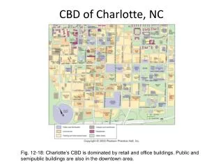
Charlotte Metropolitan Region • 2nd Largest Financial Center in US • Two Nuclear Power Plants • Lowes Motor Speedway • Major League Football and Basketball Teams • Charlotte-Douglas International Airport • Charlotte-Mecklenburg Utilities
City Service Areas (By County) CATS – 7 Counties
City Service Areas (By County) Transit – 7 Counties Fire – 14 Counties
City Service Areas (By County) Transit – 7 Counties Fire – 14 Counties Police – 11 Counties
City Service Areas (By County) Transit – 7 Counties Fire – 14 Counties Police – 11 Counties Transportation – 11 Counties
Regional Strategies:Charlotte Metropolitan Region Economic Development • Regional Comprehensive Economic Development Strategy • Charlotte Regional Partnership Public Safety and Homeland Security • Regional Radio Interoperability • Standards Initiative for Regional Preparedness Transportation • Regional Travel Demand Model • Charlotte Area Transit System Environment • Open Space Planning • Regional Vulnerability Assessment (ReVA) • Sustainable Environment for Quality of Life (SEQL) Planning Coordination • Regional Planning Alliance • Councils of Governments
Regional Strategies:Charlotte Metropolitan Region Economic Development • Regional Comprehensive Economic Development Strategy • Charlotte Regional Partnership Public Safety and Homeland Security • Regional Radio Interoperability • Standards Initiative for Regional Preparedness Transportation • Regional Travel Demand Model • Charlotte Area Transit System Environment • Open Space Planning • Regional Vulnerability Assessment (ReVA) • Sustainable Environment for Quality of Life (SEQL) Planning Coordination • Regional Planning Alliance • Councils of Governments
Meeting the Need:Enterprise Architecture Planning • Structured approach to understand existing technology infrastructure and assets and to plan for future technology investments • Documenting existing business and technology environments and relationships between • Documenting the “to-be” business processes and the supporting future technology environment • Developing a strategy and transition plan for achieving the future state
Benefits of EA • Alignment of technology with business • Reduced technology solution delivery time • Increased likelihood of success for technology solutions • Improved & exposed integration between systems • Reduction of needless complexity • Better leverage of existing legacy systems • Direction and guidance for future investments • Mission-driven introduction of new technology • Improved vendor leverage
Citizen Service Performance Measurement Technology Alignment
Principles:City Technology Investment Guidelines • Leverage Existing Technology • Buy Before Build • Drive Technology with Business Strategy • Adopt and Employ Standards • Account for Technology Training/Learning/Skills • Manage the Architecture • Measure Technology Proposals & Make Collaborative Investments • Ensure Security • Account for Disaster Recovery / Business Continuity Needs
Geospatial EA Architecture Governance Business Current Systems Application Virtual Map Book Technology Management Team (TMT) GIS Enterprise Team (GET) Data Spatial Data Warehouse, Enterprise GIS Data Model Data & Infrastructure Committee Technology Platform Development & Production Servers, SANS, SQL/Server, ArcSDE, ArcIMS Strategy & Implementation Principles
GIS Strategy • Governance & Organization • Applications • Human Capital • Budget & Finance • Data
GIS Strategic Plan:Data Recommendations • Spatial data warehouse for Enterprise GIS data • Enterprise GIS Data Model • Data standards for spatial data warehouse • Policies for data security, distribution, and access • Data stewards/custodians • Develop Address Plan • Regional data partnerships • Framework data management & coordination • Land Use data • Digital submittal standards
County Utilities Drop Zone Police EOC File Server SDE Edit Fire
History Raster Spatial Data Warehouse Land Use & Land Cover Boundaries Environment Geographic Names Hydrography Cadastral Emergency Response Transportation Capital Investment Plan Census Structures & Critical Infrastructure Health Geodetic Control Utilities
Feature Data Sets… Boundaries Cadastral Hydrography Transportation Land Use & Land Cover Geodetic Control Structures & Critical Infrastructure Capital Investment Plan Environment Geographic Names Health Emergency Response Census Utilities
Feature Data Sets… NSDI Alignment Boundaries Cadastral Hydrography Transportation Land Use & Land Cover Geodetic Control Structures & Critical Infrastructure Capital Investment Plan Environment Geographic Names Health Emergency Response Census Utilities
Feature Data Sets… State of NC Content Standards Boundaries Cadastral Hydrography Transportation Land Use & Land Cover Geodetic Control Structures & Critical Infrastructure Capital Investment Plan Environment Geographic Names Health Emergency Response Census Utilities
Raster Data… • Orthoimagery • Satellite imagery • LIDAR • Processed imagery • Gray layer • Green layer • Land cover data
Raster Data… NSDI Alignment • Orthoimagery • Satellite imagery • LIDAR • Processed imagery • Gray layer • Green layer • Land cover data
Enterprise GIS: 2004 Focus Areas • Wireless and Mobile Solutions • Regional Data • Emergency Readiness & Response • Cost Model – Fee for Service
Enterprise GIS: 2004 Focus Areas • Wireless and Mobile Solutions • Regional Data • Emergency Readiness & Response • Cost Model – Fee for Service Operation Summer Breeze 2004:
Operation Summer Breeze 2004:A Case for Geospatial Collaboration • 36-Hour Biological Terrorism Exercise • Dates: June 22-24, 2004 • Charlotte-Mecklenburg Emergency Operations Center • Scenario-based, by consultant • Amplified need for regional geospatial data • Exposed value of NC OneMap and The National Map
Operation Summer Breeze 2004:Regional Data Needs • Hospital Locations - with available beds • Street Centerlines • Addresses • Base map data - Orthophotography, hydrography • Emergency Facilities - schools, shelters, daycares, fire stations, police facilities • Socio-Economic data - by municipality and Census block/block group/tract
Regional GIS Framework Partnership: • Catawba Regional COG • Centralina Council of Governments • City of Charlotte • UNC Charlotte FGDC Grant Funding: • Institution Building & Coordination • Metadata Assistance & Outreach
Objective To provide the organizational, technical and operational structure for sharing the most current and accurate standards-based geospatial data to support citizen service and regional strategies.
National Coordination, Standards, & Funding State Data Integration, Distribution, & Maintenance The National Map Geospatial One-Stop NC OneMap Regional Data Integration & Maintenance Source Data Production & Maintenance Building the National Spatial Data Infrastructure
National Spatial Data Infrastructure Framework Themes Transportation Government Units Imagery Elevation Cadastral Hydrography Geodetic Control Land Use/ Land Cover
Strategic Linkages:State and Federal State of North Carolina • NC OneMap • Geographic Information Coordinating Council (GICC) State of South Carolina • Statewide Mapping Advisory Committee Federal • Federal Geographic Data Committee (FGDC) • Future Directions Program: Urban Areas Work Group (City of Charlotte) • Content Standards (Mecklenburg County) • Geospatial One-Stop • The National Map
Conceptual ModelRegional Geospatial Data Architecture Regional GIS DataArchitecture Access Policy GIS Data Interoperability Processing Regional GIS Stakeholder Community Data Stores Access Policy OneMap CAD E-Team Applications & Downloads
Regional GIS Data Framework Work Plan • Form Framework Steering Committee • Build GIS data sharing community • Develop governance structure and charter • Prioritize core GIS data framework layers • Develop policies for data access, security & data dissemination • Develop business model for on-going support & maintenance • Develop Strategic Plan Phase I - Planning & Initiation Phase II - Design Phase III - Implementation
Strategy Components Governance • Organizational Structure • Data Sharing Policies Business Plan • Business Case • Financial Plan Marketing & Communications • Messages, Branding & Outreach Technology Architecture Plan • Prioritized Framework Data • Existing, Future Environments • Gap Analysis
Steering Committee Representation AGENCIES DISCIPLINE Federal Geographic Data Committee NC Center for Geographic Information & Analysis USGS
Building the Geospatial Community Resource Partners Governance Business Plan Marketing & Communications Technology Architecture Plan Focus Area Subcommittees Framework Steering Committee Project Management Team
Framework Data Prioritization 10 = 14 Technology Architecture Plan, February 2005
Federal Reference Models, Standards, Requirements, Funding State Standards Regional Service Needs Regional Strategy Shaping the Geospatial Data Architecture Local Service Needs
Geospatial Coordination EA: Aligning reference models Data Architecture • Shaping content standards • Local-Regional-State-Federal Financial Model Incremental Build of national spatial data Opportunities • Grants • Mandates • Programs Governance & Organization Communication
Charlotte Enterprise Architecture: Developing the Geospatial Data Architecture GIS Charlotte…More Than Maps