Download
1 / 22
220 likes | 287 Vues
The Sensitivity of Lake-Effect Snowfall in Indiana and SW Michigan to Upstream Sounding Parameters. Craig Clark Assistant Professor of Meteorology Valparaiso University. Overview. Fun weather nerd project!

E N D
The Sensitivity of Lake-Effect Snowfall in Indiana and SW Michigan to Upstream Sounding Parameters Craig Clark Assistant Professor of Meteorology Valparaiso University
Overview • Fun weather nerd project! • Started compiling real-time cases in 2001-2002, before back-building through 1976-1977. • Green Bay, WI sounding parameters subsequently used as snowfall predictors • Snowfall data from NCDC, Indiana State Climatological Office, NWS storm reports, and CoCoRAHs • For systematic analysis, snowfall data is limited to fixed locations available through the period • Used surface maps (daily map series, Unisys archive, NSSL archive, UCAR case selection), upper air charts and soundings (Plymouth State archive), radar and satellite (UCAR case selection), and SST (GLSEA)
Defining the Cases • Defined as LES case only if conditions are favorable for LES and nearby non lake-effect stations don’t report significant snowfall • Many cases are left out, due to conflation of system and lake snow within a period • For inclusion, there must be at least 5 cm of snowfall in IN or adjacent SW MI
Indiana/SW Michigan • 228 “clean” cases from 1976-77 to 2008-2009 • Available station observations used (including Chicago) • Other locations also used for initial case assessment, but are not available for the full period (e.g. Michigan City, Elkhart, South Haven, & many CoCoRAHs observers)
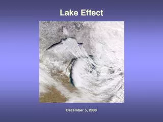
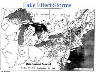
Large Spatial Variability Thanks to the North Webster NWS!
Peak Snowfall Per Event (official locations only) mean =13 cm mean=16.7 cm Frequency peaks in December and January Peak IN locations are South Bend and La Porte Focus today on IN, with SW MI used for comparison
Duration R=0.7
GRB Sounding Parameters • Instability Proxy (Temperature) • Wind Characteristics (Fetch, Shear) • Inversion Height and Strength • Upstream RH
850/700 hPa T and IN Snowfall R=-0.14 R=-0.25 • Correlation with Delta T isn’t much better • Using an estimate for 850 T over the southern half of lake • doesn’t make a big difference.
Wind Direction and IN Snowfall R=0.39 R=-.06
Wind Direction and MI Snowfall R=0.0.1 R=0.11
Wind Speed and IN Snowfall R=0.04 R=0.0
RH and Snowfall R=0.09
Simple Modeling Options for Indiana • Response variable: LN (snowfall in inches) • Peak snowfall per event (using the long-term locations, as before) • Another option is to build models for each location – doesn’t improve results! • Approach: • Linear Regression (Linear relationships are modest, but the advantages of a simpler approach are substantial) • Classification (not included here)
Best Simple Model Coefficients: Estimate Pr(>|t|) (Intercept) -7.239 3.91e-13 *** 850 W dir 0.0190 3.57e-15 *** 700 T -0.1097 5.45e-07 *** Inv Strength -0.0640 0.015194 * Sfc to 850 D Shear 0.0434 0.002435 ** 700T:Sfc/850 Dshear 0.002 0.000237 *** --- Signif. codes: 0 '***' 0.001 '**' 0.01 '*' 0.05 '.' 0.1 ' ' 1 Residual standard error: 0.8132 on 216 degrees of freedom (6 observations deleted due to missingness) Multiple R-Squared: 0.3341, Adjusted R-squared: 0.3187 F-statistic: 21.67 on 5 and 216 DF, p-value: < 2.2e-16
Best Simple Model – Including Duration Coefficients: Estimate Pr(>|t|) (Intercept) -4.354 8.51e-10 *** 850 W dir 0.0102 5.11e-09 *** 700T -0.0572 0.000211 *** Inv Strength -0.0302 0.100371 Sfc to850 D Shear 0.0286 0.004323 ** Snow Days (1 inch) 0.7947 2e-16 *** 700T:Sfc850Dshear 0.0013 0.001900 ** --- Signif. codes: 0 '***' 0.001 '**' 0.01 '*' 0.05 '.' 0.1 ' ' 1 Residual standard error: 0.5656 on 215 degrees of freedom (6 observations deleted due to missingness) Multiple R-Squared: 0.6793, Adjusted R-squared: 0.6704 F-statistic: 75.91 on 6 and 215 DF, p-value: < 2.2e-16
Predictions and Observations Note 2 outliers ->
Summary • Most cases have moderate snowfall, but heavy cases are not rare. • The big cases look obvious post-mortem, but plenty of similar environments result in much less snowfall. • Upstream temperature is important, but wind direction is the most valuable predictor. • The relationship to wind direction changes for the various locations (e.g. Valparaiso vs Benton Harbor). • Temperature/instability seems to act mostly as a limiting factor. • Linearity is fairly weak – which makes forecasting tricky!
Sources Ballentine, R.J., 1982: Numerical simulations of land-breeze-induced snowbands along the western shore of Lake Michigan. Mon. Wea. Rev., 110, 1544-1553. Forbes, S. F., and J.H. Merritt, 1984: Mesoscale vortices over the Great Lakes in wintertime. Mon. Wea. Rev., 112, 377-381. Hjelmfelt, M.R., 1990: Numerical study of the influence of environmental conditions on Lake-effect snowstorms over Lake Michigan. Mon. Wea. Rev., 118, 138-150. Hjelmfelt, M.R., and R.R. Braham, Jr., 1983: Numerical simulation of the airflow over Lake Michigan for a major lake-effect snow event. Mon. Wea. Rev., 111, 205-219. Kristovich, D.A.R., N. F. Laird, and M. R. Hjelmfelt, 2003: Convective evolution across Lake Michigan during a widespread lake-effect snow event. Mon. Wea. Rev.,131, 643-655. Laird, N. F., Kristovich, D.A.R., and J.E. Walsh, 2003: Idealized model simulations examining the meoscale structure of winter lake-effect circulations.Mon. Wea. Rev.,131, 206–221. Niziol, T.A., 1987: Operational forecasting of lake-effect snowfall in western and central New York. Wea. Forecasting, 2, 310-321. Rothrock, H.J., 1969: An aid in forecasting significant lake snows. Environmental Science Services Administration Tech. Memo. WBTM CR-30. 12pp. Data: http://docs.lib.noaa.gov/rescue/dwm/data_rescue_daily_weather_maps.html http://www.mmm.ucar.edu/imagearchive/ http://vortex.plymouth.edu/u-make.html http://data.nssl.noaa.gov/ http://www7.ncdc.noaa.gov/CDO/cdo http://www.weather.unisys.com/archive/index.html http://coastwatch.glerl.noaa.gov/glsea/ http://climate.agry.purdue.edu/climate/index.asp http://www.crh.noaa.gov/iwx/ http://www.crh.noaa.gov/lot/