Download
1 / 16
310 likes | 696 Vues
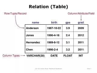
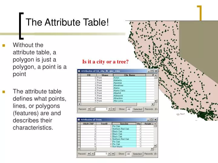
The Attribute Table! . Without the attribute table, a polygon is just a polygon, a point is a point The attribute table defines what points, lines, or polygons (features) are and describes their characteristics. . Is it a city or a tree? . The Attribute Table! . Area. 2745.767.

E N D
The Attribute Table! • Without the attribute table, a polygon is just a polygon, a point is a point • The attribute table defines what points, lines, or polygons (features) are and describes their characteristics. Is it a city or a tree?
Area 2745.767 796.5096 1840.4960 The Attribute Table! • You can add/associate data to your attribute table by: • creating a new field • joining (one-to-one) • relating (one-to-many records)
Schools The Attribute Table! • You can add/associate data to your attribute table by: • creating a new field • joining (one-to-one) • relating (one-to-many records)
Most Common! Relational Database Model Types of relationships Cardinality - one-to-one, one-to-many, many-to-many Examples…? state capitol to state state to cities cities to state Keysfields are used to create relationships between tables. Can be a number or a text field. Always create a relationship from the spatial table (shapefile, geodatabse) to the non-spatial table
Joins and Relates Two ways of linking an external table to a shapefile or geodatabase • One-to-One relationship • is created using the JOIN operation • external table is appended to your shapefile/geodatabase attribute table • One-to-Many relationship • is created using the RELATE operation • external table is physically separate from • the attribute table
Joins • A join appends the fields from the non-spatialtable to the spatial table. • You can symbolize and query table information that is contained in the non-spatial table Spatial Layer shapefile, geodatabase Non-Spatial Layer table (dbf, csv, txt) Ave00
Joins NAME Spatial Layer shapefile, geodatabase Non-Spatial Layer table
Relates • Cannot symbolize • Cannot use “select by attribute” across tables • A relate does not append the fields from the non-spatial to spatial table (tables separate) Non - Spatial Table Spatial Table
Relates Spatial Layer shapefile, geodatabase Non-Spatial Layer table
Joining and Relating Tables • 1 to 1 Join • 1 to Many Relate • Many to 1 Join • Many to ManyRelate Allows link from the spatial table to the external table! (right-click on the shapefile/geodatabes to begin the join or relate)
Manipulation of Fields and Attribute Data – Adding and Deleting Fields Add Fields from the Options button in the attribute table Delete Fields by right-clicking on the field
Manipulation of Fields and Attribute Data – Adding Fields Add Fields from the Options button in the attribute table
Manipulation of Fields and Attribute Data – Field Calculator • Saves time in data entry - automatically calculate values for a field • copying • concatenating • creating new values using mathematical operations (add field 1 to field 2) • -Advanced Field Calculator • performs advanced calculations using Visual Basic for Applications (VBA) statements Right-click on field heading Field Calculator
Manipulation of Fields and Attribute Data - Summarize • Summarizing allows you to • aggregate your records by a field • sum • average • count • minimum • maximum value • standard deviation • variance • ArcMap creates a new table • containing the summarized data • Useful for joining tables
Manipulation of Fields and Attribute Data - Summarize • Right-click field • Summarized Dialog • Create a new table