Download
1 / 17
170 likes | 290 Vues
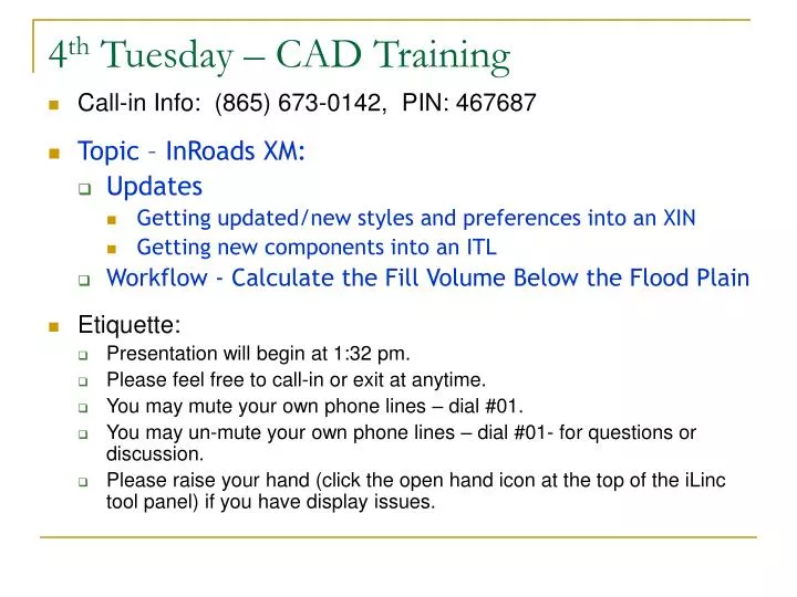
4 th Tuesday – CAD Training. Call-in Info: (865) 673-0142, PIN: 467687 Topic – InRoads XM: Updates Getting updated/new styles and preferences into an XIN Getting new components into an ITL Workflow - Calculate the Fill Volume Below the Flood Plain Etiquette:

E N D
4th Tuesday – CAD Training • Call-in Info: (865) 673-0142, PIN: 467687 • Topic – InRoads XM: • Updates • Getting updated/new styles and preferences into an XIN • Getting new components into an ITL • Workflow - Calculate the Fill Volume Below the Flood Plain • Etiquette: • Presentation will begin at 1:32 pm. • Please feel free to call-in or exit at anytime. • You may mute your own phone lines – dial #01. • You may un-mute your own phone lines – dial #01- for questions or discussion. • Please raise your hand (click the open hand icon at the top of the iLinc tool panel) if you have display issues.
Do I need to update my XIN or ITL? • If you use a custom (project-specific) XIN, you may want to have access to new styles and preferences after a workspace update. Updating styles will also update the named symbologies. • Did you know that you can change XINs while you are running InRoads? • We use a copy of the ODOTseed.ITL for our projects. If new components were created, you may want to use them. You can also reuse templates from other project ITLs or IRDs!
Copy Preference Add-In Tools>Application Add-Ins Place a check next to Copy Preference Add-In Once that’s done – Copy Preferences… will appear on the Tools menu.
How do I know what has changed? INROADS XIN CHANGES: 8 Nov 2010 Modified the ODOT preference set: Toggled “Duplicate Names” to Rename for the Merge Surfaces and Transform Surfaces dialog boxes defaults. Toggled on Scale in Plan and/or Profile Line symbology for the following named symbologies that use custom line styles: CL_Minor, HY_Stream_OHW_E, HY_Stream_TopWater_Thalweg_E, HY_Stream_TopWater_Thalweg_E_S, Util_Elec_Ln_Oh_E, and Util_Elec_Ln_Oh_E_S. Deleted Rdway_Gutter_Line_E named symbology (not used). Added named symbologies and styles for cross section display of features: Xsec_EP_Label_E, Xsec_Gas24_Top_E, and Xsec_Pipe18_FL_E. 9 Nov 2010 Added named symbologies and styles for leveling and grinding components Mat-Grinding and Mat-Leveling Modified CL_Existing named symbology to match CPDG. Added CL_Existing preference for Geometry>View Geometry>Stationing to place stationing to match color, weight, and text height of CL_Existing named symbology. Modified all CL_ preferences for Stationing to select ODOT Vertical (font 2) as font for major station text to match CPDG. 16 Nov 2010Added named symbologies and styles for more material types: Mat-Conc-Wall; Mat-Conc-Curb; Mat-Conc-DrainageCurb; Mat-Conc-Sidewalk; Mat- MSE-Wall
Update the XIN - Styles Source = civil.xin in your F:\ODOT_DATA\ENG_APP\InRoads folder STYLES Preferences and Filters Destination = The currently loaded XIN (01234.xin)
How do I know what has changed? INROADS XIN CHANGES: 8 Nov 2010 Modified the ODOT preference set: Toggled “Duplicate Names” to Rename for the Merge Surfaces and Transform Surfaces dialog boxes defaults. Toggled on Scale in Plan and/or Profile Line symbology for the following named symbologies that use custom line styles: CL_Minor, HY_Stream_OHW_E, HY_Stream_TopWater_Thalweg_E, HY_Stream_TopWater_Thalweg_E_S, Util_Elec_Ln_Oh_E, and Util_Elec_Ln_Oh_E_S. Deleted Rdway_Gutter_Line_E named symbology (not used). Added named symbologies and styles for cross section display of features: Xsec_EP_Label_E, Xsec_Gas24_Top_E, and Xsec_Pipe18_FL_E. 9 Nov 2010 Added named symbologies and styles for leveling and grinding components Mat-Grinding and Mat-Leveling Modified CL_Existing named symbology to match CPDG. Added CL_Existing preference for Geometry>View Geometry>Stationing to place stationing to match color, weight, and text height of CL_Existing named symbology. Modified all CL_ preferences for Stationing to select ODOT Vertical (font 2) as font for major station text to match CPDG. 16 Nov 2010Added named symbologies and styles for more material types: Mat-Conc-Wall; Mat-Conc-Curb; Mat-Conc-DrainageCurb; Mat-Conc-Sidewalk; Mat- MSE-Wall
Update the XIN - Preferences Preferences control how dialog boxes are filled out Styles – selection set PREFERENCES – one at a time Destination = The currently loaded XIN (01234.xin)
How do I know what has changed? ENG_APP CHANGES: 16 Nov 2010Modified ODOTseed.itl: Edited CurbTF and CurbTB points in Curb, Low Profile, Mountable component to remove true vertical between EP and CurbTF. CurbTF is offset from EP by -0.001 and CurbTB horizontal position in component is -1.000. Applied Mat-Conc-Curb to Curb, Low Profile, Mountable; Curb, Mountable; and Curb, Standard. Applied Mat-Conc-DrainageCurb to Drainage Curb; and Drainage Curb, Under Guardrail. Applied Mat-Conc-sidewalk to Sidewalk. Added all additional points (15) to Point Name List. 12 Nov 2010 4. Use feature name override for interception points of end conditions: Reports will show simply SSC_L, SSC_R, SSF_L, and SSF_R. Toggle on “Feature Name Override” and use either SSC or SSF in Point Properties for all interception points on all end condition components (multiple) 5. Modified the constraints on all SGSh points in components to be slope from EP-SG, slope from EP or Erk, and labeled the slope constraint from EP or Erk to be RockSlope.
Update the ITL Template Library Organizer… Left side Destination 01234_new.itl Left side Destination 01234.itl Right side Source 01234.itl Right side Source ODOTseed.itl
Update the ITL from an IRD Each corridor is shown as a folder – each template drop is shown beneath.
Calculating Fill Below the Flood Plain FG Flood plain Fill OG
5 Steps • Create or receive the existing and proposed surfaces. • Create child vertical alignment of roadway that contains elevations of floodplain (this is typically not flat) – mine just has 3 PIs. • Create a floodplain surface by running a corridor with a flat template along the proposed roadway with the floodplain vertical alignment and targeting the proposed surface. Create this surface without an exterior boundary. • Copy exterior boundary of proposed surface into floodplain, trim, and triangulate - this gives you the difference surface between proposed and floodplain. • Use triangle volume or end-area volume to calculate difference between existing and the combined floodplain/proposed. That gives you the volume of fill below the floodplain elevation.
Merging the surfaces “Merge” the modeled floodplain surface with the proposed surface: Use Copy Portion of Surface and copy the Exterior Boundary from the proposed surface into the floodplain surface, then triangulate. Source Surface = Proposed Destination Surface = Floodplain Features: select the exterior boundary and any other feature on the proposed surface that is outside the floodplain catch.
Calculating Fill Below the Flood Plain FG Flood - FG Flood Fill OG FG Exterior Boundary Points End-Area Volume between OG and (Flood – FG)
Calculate Volume Use Triangle or End-Area Volume to calculate volume of fill below the floodplain elevation by taking the difference between the original ground surface and the floodplain combined with the proposed surface.
Questions • When you created the flood surface in the demo, the active surface was set to the OG – why did the flood surface still catch against the proposed fill slopes? • Just to confuse you, it seems. I was messing around quite a bit with the data and had set up Target Aliasing for the Flood corridor. No matter what had been set as the active surface, the Target Aliasing said to catch against the proposed surface first and then against the original ground if the proposed wasn’t present. You should do as I said (not as I did) and set the active surface to the proposed when creating the flood surface. • When you displayed the perimeter of the Flood surface, it extended out beyond the perimeter of the proposed fill – why? • Again, this was because I had target aliasing set up. When the corridor reached the end of the proposed fill (it stopped at the structure), it started catching against the original ground instead of just failing. It would have been better if I had limited my corridor stations to stop at the same station that the proposed fill stopped. Some of you probably noticed some empty cross sections at the beginning also. You should be very careful with the start and stop stations of your cross sections when running the volumes; don’t include stations where you don’t have both surfaces.