Download
1 / 30
300 likes | 435 Vues
Old Brick Township Comprehensive Plan Amendment (CPA). BACKGROUND. Planning and Land Development Regulation Board (PLDRB) previously heard & acted on Comprehensive Plan Amendment on April 15, 2009, recommend transmittal to DCA for interagency review

E N D
BACKGROUND • Planning and Land Development Regulation Board (PLDRB) previously heard & acted on Comprehensive Plan Amendment on April 15, 2009, recommend transmittal to DCA for interagency review • Previous proposal was for DRI-MU for all lands • Presentation of Development Order Conditions on July 21, 2010
PROCESS • State Statutes require consideration of DRI-Development Order (DO) and associated Comprehensive Plan Amendment at same public hearing • Implementation of DO depends on approval of Comprehensive Plan
BACKGROUND • Previous application to designate all lands DRI-MU
Department of Community Affairs – Objections, Recommendations, and Comments (ORC) Report • Objections: • Site Suitability • Need • Urban Sprawl • Impacts to public infrastructure & water supply
Response to ORC • The City took a regional approach to planning: • to avoid piecemeal development and • provide for regional connections for wildlife, transportation and utilities • Coordination with agencies • Update of Comprehensive Plan • Creation of NCOA • Extend planning horizon including water supply plan • Data and Analysis
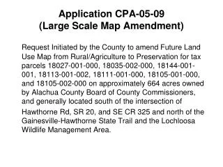
PROPOSAL AND LOCATION MAP • FLUM Amendment-Development of Regional Impact-Mixed Use (DRI-MU) and Conservation • Footnotes on FLUM – expansion of Conservation areas, conversion of land uses, concentration of density around Village Center, phasing schedule • Text Amendment to Future Land Use Element and Capital Improvements Element
Objections, Recommendations, and Comments (ORC) Report • Objections: • Site Suitability • Need • Urban Sprawl • Impacts to public infrastructure & water supply
Addressing Site Suitability • Data and Analysis • Coordination with Agencies • Ecological Corridor Technical Working Group • Identifying Resources • Protecting Resources • Conservation FLUM • NCOA Sequencing Process • NCOA Guiding Policies
Addressing Site Suitability • Protecting Resources • Consistent with Comprehensive Plan • Designation of highest quality environmental resources as “Conservation”
Addressing Site Suitability • Protecting Resources • Consistent with Comprehensive Plan • Designation of highest quality environmental resources as “Conservation”
Addressing Site Suitability • Protecting Resources • Consistent with Comprehensive Plan • Designation of highest quality environmental resources as “Conservation”
Addressing Site Suitability • Protecting Resources –NCOA Sequencing Process • Target strategies to enhance moderate to low quality resources • Linking environmentally sensitive lands • Implement Greenway – Regional Corridor Concept • Protection and long-term management of environmental resources
Addressing Site Suitability • Additional NCOA Guiding Policies Related to Site Suitability • Long-term resource protection • Setbacks and buffers • Low Impact Development - Complementing Land-uses • Minimizing Human-Wildlife Conflicts • Living with Wildlife and Land Management
Addressing Needs • DCA’s objections was based on City’s need through 2020 Planning Horizon • Subsequently, planning horizon extended to 2035
Addressing Urban Sprawl • There are 13 Primary Indicators of Urban Sprawl in Florida Administrative Code (FAC) • Indicators are based on: • land use patterns (promotes attractive and functional mix of uses, linkage between land uses), • protection of natural resources, agriculture & open space areas, and • maximize use of existing and planned public facilities and infrastructure
Addressing Public Facilities Impacts • Public Facilities Impact Analysis • Transportation – No impacts on existing roadway within first 5-year • Developer proposes project in 5-year Capital Improvements Schedule (CIS) to extend roadway network to accommodate project • Water and Sewer • Developer proposes projects in 5-year Capital Improvements Schedule (CIS) to extend water and sewer lines to accommodate project • Demand included in update of water supply plan
Addressing Public Facilities Impacts • Solid Waste • Interlocal agreement with Volusia County to accept solid waste until 2026 • Recreation and Open Space • Developer will contribute park lands to mitigate impacts on recreation and open space • Stormwater • LOS standards are reviewed during site plan approval
Addressing Public Facilities Impacts • Public School Facilities • Coordination with School District for impacts and mitigation • Developer to contribute school site, pay impact fees, and impact fee surcharge to mitigate impacts on public school facilities • Other services - Fire service • Developer to contribute 3 acre site for fire station
Support • St. Johns County “Due to interagency cooperation over the past year and its proximal location to St. Johns County, the City of Palm Coast is and will continue to be an integral part of the County’s planning strategies, from linking planned greenway corridors to concurrent development reviews”.
Support • Flagler County “Flagler County staff has been in attendance at numerous meetings where the Northwest Corridor Overlay Area corridor concept has been discussed. We support forward thinking, progressive land planning and believe natural resource should be considered throughout the development process. We appreciate the City’s efforts to keep Flagler County in the loop”.
Support • FWC “Our staff would like to express our appreciation for your efforts to accommodate our mission of ensuring the long term sustainability of fish and wildlife resources for their benefit and the benefit of people. In particular we are very supportive of your efforts to address this activity through amendments to the City’s comprehensive plan and land development code.” “It’s the opinion of our subject matter experts that this language is a very accurate reflection of those discussions and is much appreciated in that it would support many species beyond just the black bear.”
RECOMMENDATION • Staff Recommends that the Planning and Land Development Regulation Board (PLDRB) find the proposed Comprehensive Plan Amendments consistent with the Comprehensive Plan and recommend that the City Council approve the proposed Comprehensive Plan Amendment.