Download
1 / 25
250 likes | 403 Vues
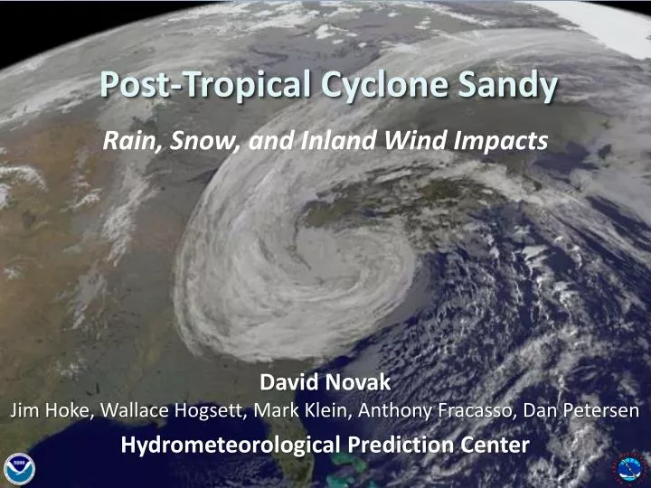
Post-Tropical Cyclone Sandy. Rain, Snow, and Inland Wind Impacts. David Novak Jim Hoke , Wallace Hogsett , Mark Klein, Anthony Fracasso , Dan Petersen Hydrometeorological Prediction Center. Jamaica Landfall. 973 mb. Cuba Landfall. Pressure ( mb ). 957 mb. New Jersey Landfall.

E N D
Post-Tropical Cyclone Sandy Rain, Snow, and Inland Wind Impacts David Novak Jim Hoke, Wallace Hogsett, Mark Klein, Anthony Fracasso, Dan Petersen Hydrometeorological Prediction Center
Jamaica Landfall 973 mb Cuba Landfall Pressure (mb) 957 mb New Jersey Landfall 946 mb Symmetric Warm Core Asymmetric Warm Core Asymmetric Cold Core
A Success for Ensembles and Forecasters Charts Valid 12Z October 29, 2012 Surface Analysis 7 day forecast GEFS Member ECMWF Member CMC Member ECMWF Mean 247 nm Displacement NAEFS Mean FOR NOW, HAVE KEPT THE INCREASINGLY HYBRID CYCLONE OFF THE EAST COAST, THOUGH NOT AS FAR OUT TO SEA AS THE GFS AND GEFS MEMBERS. CONSIDERING THE WILDLY DIVERSE DETERMINISTIC SOLUTIONS AND ENSEMBLE MEMBERS…THAT SEEMS TO HAVE BEEN A SAFE BET. CISCO 558 DM Height GEFS Mean GFS ECMWF
A Success for Ensembles and Forecasters Charts Valid 12Z October 29, 2012 Surface Analysis 6 day forecast 7 day forecast GEFS Member ECMWF Member CMC Member ECMWF Mean 186 nm Displacement 247 nm Displacement NAEFS Mean THERE HAVE BEEN GFS ENSEMBLE MEMBERS QUITE SIMILAR TO THE ECMWF/GEM CAMP FOR THE LAST FEW DAYS OF MODEL CYCLES, PUTTING THE DETERMINISTIC GFS SOLUTIONS IN A BROADER FRAMEWORK… CISCO 558 DM Height GEFS Mean GFS ECMWF
A Success for Ensembles and Forecasters Charts Valid 12Z October 29, 2012 Surface Analysis 6 day forecast 7 day forecast 5 day forecast GEFS Member ECMWF Member CMC Member ECMWF Mean 186 nm Displacement 247 nm Displacement 89 nm Displacement NAEFS Mean THE DETERMINISTIC SOLUTIONS… ARE OUTLIERS TO THE MAJORITY OF THEIR ENSEMBLE BROTHERS AND SISTERS, WITH THE LION'S SHARE OF THE ENSEMBLE GUIDANCE INDICATING A WHOLESALE INCORPORATION OF SANDY'S POST-TROPICAL CIRCULATION INTO THE UPPER VORTEX… 558 DM Height GEFS Mean GFS ECMWF
Low Track Forecast – 1.5 days prior to landfall * Note the ensemble spread at each forecast time. • SREF uncertainty in acceleration of storm 36 hours before landfall • Ensemble mean was very accurate (00 UTC landfall) Storm accelerated towards New Jersey coast
A Success for Ensembles and Forecasters Charts Valid 12Z October 29, 2012 Surface Analysis 6 day forecast 7 day forecast 5 day forecast 1 day forecast 2 day forecast 4 day forecast 3 day forecast
H 1028 L 940
Wind and Wave Forecasts 39 h Forecast SREF Max Wind Gust 65 mph 18 h Forecast 1.33 km NAM Wind Gust 75+ mph Great Lakes Coastal Forecast System Courtesty Peter Manousos (First Energy) Issued Sunday Morning, Oct 28 77 kts 19’ Issued Saturday Evening, Oct 27 Issued Monday Morning, Oct 28
Great Lakes Impacts Wave Height Water Level Impacts 21.7’ Second Highest since 1980 1’ Surge Lake Michigan AP 14’ 1-2’ Surge Lake Erie USCG
Rainfall Very accurate rainfall forecasts 5 Day Precipitation Forecast: Issued Friday morning, Oct 26 3 Day Precipitation Forecast: Issued Sunday morning, Oct 28 Observed Rainfall Oct 23, 2012 Rainfall alleviated drought D0-D4: 24% of area 16
Rainfall Very accurate rainfall forecasts 5 Day Precipitation Forecast: Issued Friday morning, Oct 26 3 Day Precipitation Forecast: Issued Sunday morning, Oct 28 Observed Rainfall Oct 30, 2012 Rainfall alleviated drought D0-D4: 12% of area
Inland Flooding Monocacy Potomac Goose Creek
Snowfall 7 Days Prior to Landfall: “…BESIDES THE WIND, THE OTHER SENSIBLE WEATHER THREAT IS HEAVY RAINS, WITH HEAVY SNOWS POSSIBLE ON THE SOUTHWEST SIDE OF THE HYBRID CIRCULATION…” CISCO 30”+ 3 day Snow Total: Issued Sunday morning, Oct 28
Sandy Snowfall 30”+ Snowshoe, WV
Coordinating the Message • HPC QPF linked at NHC • Sandy-specific products highlighted on HPC homepage • Internal: NOC, FEMA, Regions, WFOs • External: Media (CNN, Univision, ABC, etc.), Congressional visitors, etc.
Post-Tropical Cyclone Sandy Summary • A historic event • Unusual track • Rare evolution • Historic impacts • An accurate forecast • Heavy reliance on ensemble datasets • Accomplishment of the Weather Enterprise • A coordinated message • The Weather Enterprise saved lives and property