Download
1 / 22
430 likes | 1.6k Vues
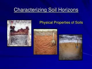
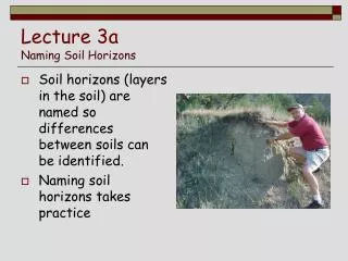
Soil Profile and Soil Horizons . Presented by: Mr. Brian Oram, PG, PASEO Wilkes University GeoEnvironmental Sciences and Environmental Engineering Department Wilkes - Barre, PA 18766 570-408-4619 http://www.water-research.net. Time for Review. Definition of Soils.

E N D
Soil Profile and Soil Horizons Presented by: Mr. Brian Oram, PG, PASEOWilkes UniversityGeoEnvironmental Sciences and Environmental Engineering DepartmentWilkes - Barre, PA 18766570-408-4619 http://www.water-research.net
Definition of Soils • A Natural 3 - Dimensional Body at the Earth Surface • Capable of Supporting Plants • Properties are the Result of Parent Material, Climate, Living Matter, Landscape Positionand Time- 5 Soil Forming Factors. • Soil Composed of 4 Components (mineral matter, organic matter, air, and water)
Major Components of Soil • Soil Space (50%) • Organic Matter • Mineral Matter Pore Space (50%) • This may contain air and/or water
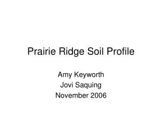
Where is the Rock Contact ? Where is the Regolith ? Where is the Soil ? Soil Rock ?Regolith?Soil? What are these? Regolith Rock
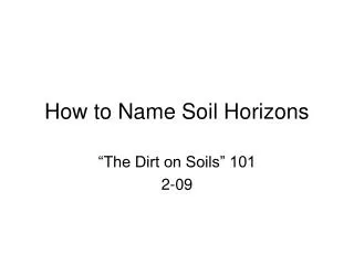
Polypedons and Pedons • This is the smallest unit used for soil mapping (1 to 10 m2) • This is a 3 Dimensional Structure that extends to the limits of the genetic soil horizons • Unit is large enough to describe the vertical and lateral variation in the soil • Polygonal Surface • Described as Unit of Sampling • A combination of pedons is a polypedon. Polypedon represents a single soil series or soil individual
Polypedon Pedon
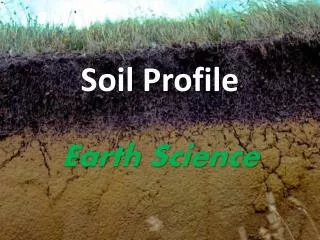
Soil Profile • Vertical or Near Vertical Arrangement of Horizons that Tend to Parallel the Ground Surface to Parent Material • This is a 2 Dimensional Structure Pieces of Black Top Image Source: Field Trip North Carolina (2005) – Outer Banks
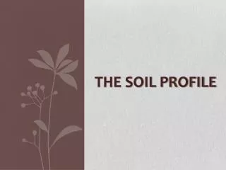
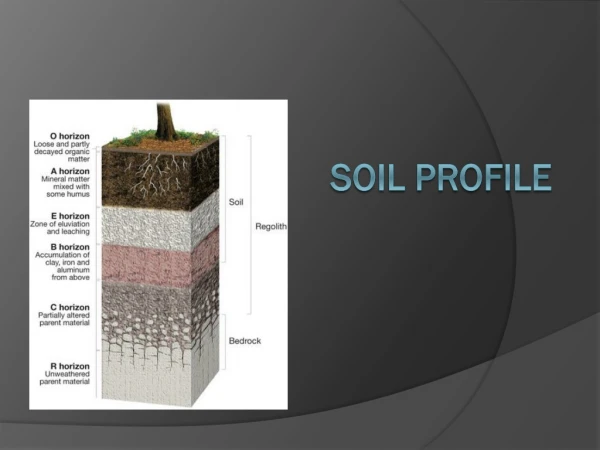
Soil Horizons • Layer of Soil Parallel to Surface • Properties a function of climate, landscape setting, parent material, biological activity, and other soil forming processes. • Horizons (A, E, B, C, R, etc) Image Source: University of Texas, 2002
Master Soil Horizons • O Horizon- leaf litter / humus • A Horizon- organic accumulation in mineral soil • E Horizon- leached horizon (elluviation) • B Horizon- zone of illuviation • C Horizon – unconsolidated parent material • R Horizon – lithic material (Rock)> R Not All the Master Horizons Will Be Present in All Profiles
Soil HorizonsO- Organic Horizons • Organic Layers of Decaying Plant and Animal Tissue • Aids Soil Structural Development • Helps to Retain Moisture • Enriches Soil with Nutrients • Infiltration Capacity function of Organic Decomposition • Organic Matter Critical in Maintaining Water Stable Peds O Horizon Dark in Color Because of Humus Material - 1,000,000 bacteria per cm3
Soil HorizonsA Horizons: “ Topsoil” • Mineral Horizon NearSurface • Eluviation Process Moves Humic and Minerals from O Horizon into A horizon Subordinates • Ap - Plowed A Horizon • Ab - Buried Horizon • Soil dark in color, coarser in texture, and high porosity A Horizon
Soil Horizons: E HorizonsAlbic Horizon (Latin - White) • Mineral Horizon NearSurface • Movement of Silicate Clay, Iron, and Aluminum from the A Horizon through Eluviation • Horizon does not mean a water table is present, but the horizon can be associated with high water table , use Symbol Eg (gleyed modifier) • Underlain by a B (illuvial) horizon E Horizon
Soil Horizons: B HorizonsZone of Maximum Accumulation • Mineral Horizon • Illuviation is Occurring - Movement into the Horizon • B Horizon Receives or Accumulates Organic and Inorganic Materials from Upper Horizons. • Color Influence by Organic, Iron, Aluminum, and Carbonates Subordinantes • Bw - Weakly Colored or Structured Bw Horizon
Soil Horizons: B HorizonsZone of Maximum Accumulation Other Subordinantes • Bhs- Accumulation of illuvial organic material and sesquioxides • Bs- Accumulation of sesquioxides • Bt- Translocation of silicate clay • Bx- Fragipan Horizon, brittle • Bw-Weakly Colored and Structured Bhs Horizon Bs Horizon Bw Horizon
Soil Horizons: Bx and Bt Horizons Horizons Indicate Reduced Infiltration Capacity and Permeability Bx: B horizon with fragipan, a compact, slowly permeable subsurface horizon that is brittle when moist and hard when dry. Prismatic soil structure, mineral coatings and high bulk density Area of Highest Permeability along Prism Contact Bt: Clay accumulation is indicated by finer soil textures and by clay coating peds and lining pores
C- HorizonsDistinguished by Color, Structure, and Deposition • Mineral Horizon or Layer, excluding Rock • Little or No Soil-Forming • May be Similar to Overlying Formation • May be Called Parent Material • Layer can be Gleyed (Redoximorphic Feature) • Developed in Place or Deposited • May be Weathered Parent Material
R- Horizons • Hard, Consolidated Bedrock(Lithic Material) • Typically Underlies a C Horizon, but could be directly below an A or B Horizon. R Horizon
Soil Horizons and Typical Structures Source: http://www.vanaturally.com/soil.html
Answer the FollowingFill In the Blanks Weathering • _________ breakdown of parent material and organic matter. • __________ removal of clay, iron, humus, and aluminum compounds by soil solution. • __________ deposition of translocated materials due to the drying of soil solution. • __________ feature associated with the reduction of iron by wetness (saturation and anaerobic conditions) Eluviation Illuviation Redoximorphic Possible Answers: Eluviation, Redoximorphic, Illuviation or Accumulation,Weathering
Soil Horizons Presented by: Mr. Brian Oram, PG, PASEOWilkes UniversityGeoEnvironmental Sciences and Environmental Engineering DepartmentWilkes - Barre, PA 18766570-408-4619 http://www.water-research.net