Download
1 / 1
10 likes | 156 Vues
Channel Repair of Montezuma Creek in Coronado National Memorial following Fire and Flood Damage Stephanie Yard, P.E. & Allen Haden, Aquatic Ecologist Natural Channel Design, Inc., Stephanie@naturalchanneldesign.com, Allen@naturalchanneldesign.com.

E N D
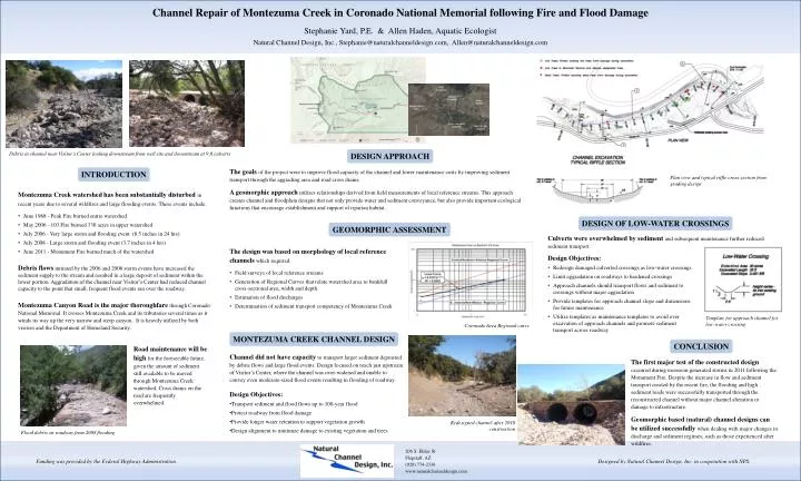
Channel Repair of Montezuma Creek in Coronado National Memorial following Fire and Flood Damage Stephanie Yard, P.E. & Allen Haden, Aquatic Ecologist Natural Channel Design, Inc., Stephanie@naturalchanneldesign.com, Allen@naturalchanneldesign.com Debris in channel near Visitor’s Center looking downstream from well site and downstream at 9 ft culverts DESIGN APPROACH The goals of the project were to improve flood capacity of the channel and lower maintenance costs by improving sediment transport through the aggrading area and road cross drains. A geomorphic approach utilizes relationships derived from field measurements of local reference streams. This approach creates channel and floodplain designs that not only provide water and sediment conveyance, but also provide important ecological functions that encourage establishment and support of riparian habitat. INTRODUCTION Plan view and typical riffle cross-section from grading design • Montezuma Creek watershed has been substantially disturbed in recent yearsdue to several wildfires and large flooding events. These events include: • June 1988 - Peak Fire burned entire watershed • May 2006 - 103 Fire burned 330 acres in upper watershed • July 2006 - Very large storm and flooding event (8.5 inches in 24 hrs) • July 2008 - Large storm and flooding event (3.7 inches in 4 hrs) • June 2011 - Monument Fire burned much of the watershed • Debris flows initiated by the 2006 and 2008 storm events have increased the sediment supply to the stream and resulted in a large deposit of sediment within the lower portion. Aggradation of the channel near Visitor’s Center had reduced channel capacity to the point that small, frequent flood events ran over the roadway. • Montezuma Canyon Road is the major thoroughfare through Coronado National Memorial. It crosses Montezuma Creek and its tributaries several times as it winds its way up the very narrow and steep canyon. It is heavily utilized by both visitors and the Department of Homeland Security. DESIGN OF LOW-WATER CROSSINGS GEOMORPHIC ASSESSMENT Culverts were overwhelmed by sediment and subsequent maintenance further reduced sediment transport. • The design was based on morphology of local reference channels which required: • Field surveys of local reference streams • Generation of Regional Curves that relate watershed area to bankfull cross-sectional area, width and depth. • Estimation of flood discharges • Determination of sediment transport competency of Montezuma Creek • Design Objectives: • Redesign damaged culverted crossings as low-water crossings • Limit aggradation on roadways to hardened crossings • Approach channels should transport flows and sediment to crossings without major aggradation • Provide templates for approach channel slope and dimensions for future maintenance • Utilize templates as maintenance templates to avoid over excavation of approach channels and promote sediment transport across roadway Template for approach channel for low-water crossing Coronado Area Regional curve MONTEZUMA CREEK CHANNEL DESIGN CONCLUSION Road maintenance will be high for the foreseeable future, given the amount of sediment still available to be moved through Montezuma Creek watershed. Cross drains on the road are frequently overwhelmed. Channel did not have capacity to transport larger sediment deposited by debris flows and large flood events. Design focused on reach just upstream of Visitor’s Center, where the channel was over-widened and unable to convey even moderate-sized flood events resulting in flooding of roadway. The first major test of the constructed design occurredduring monsoon generated storms in 2011 following the Monument Fire. Despite the increase in flow and sediment transport created by the recent fire, the flooding and high sediment loads were successfully transported through the reconstructed channel without major channel alteration or damage to infrastructure. Geomorphic based (natural) channel designs can be utilized successfullywhen dealing with major changes in discharge and sediment regimes; such as those experienced after wildfires. • Design Objectives: • Transport sediment and flood flows up to 100-year flood • Protect roadway from flood damage • Provide longer water retention to support vegetation growth • Design alignment to minimize damage to existing vegetation and trees Redesigned channel after 2010 construction Flood debris on roadway from 2008 flooding 206 S. Elden St Flagstaff, AZ (928) 774-2336 www.naturalchanneldesign.com Funding was provided by the Federal Highway Administration. Designed by Natural Channel Design, Inc. in cooperation with NPS.