Download
1 / 20
200 likes | 349 Vues
Case Review: 16-17 September 1999. Heavy Rainfall from Landfalling Hurricane-1. Learning Objectives (1)To apply the QPF principles discussed in lecture by considering the synoptic-scale forcing (if any) and the anticipated mesoscale contribution for this major rainfall event.

E N D
Case Review: 16-17 September 1999.Heavy Rainfall from Landfalling Hurricane-1 Learning Objectives (1)To apply the QPF principles discussed in lecture by considering the synoptic-scale forcing (if any) and the anticipated mesoscale contribution for this major rainfall event. (2) To anticipate both meteorological and orographic contributions to rainfall production and distribution during hurricane Floyd. (3) Get experience with Radar, Satellite, and NWP data to embellish lecture material and other case review exercises. Materials Provided (1) Quick hand analyses of surface pressure (every 2 mb) and dewpoint (every 4oF) beginning at 54oF for 1200 UTC 16 September. (2) Hand analysis of 250 mb isotachs (every 20kt beginning at 60 kt), 850 mb dewpoints (every 2oC beginning at 6oC) at 1200 UTC 16 September. (3) Northeast states, counties, SAO locations, and topo map.
Case Review: 16-17 September 1999.Heavy Rainfall from Landfalling Hurricane-1 Assignment After a weather discussion of the hurricane as of 1200 UTC 16 September: • Review any data through 1200 UTC 16 September, • including any model forecasts from the 0000 UTC 16 Sep model runs, • and model analyses from the 1200 UTC 16 Sep cycle (on AWIPS you need to select “analysis loop” as your load mode). 1.Prepare a 24-h QPF for the period ending 1200 UTC 17 September on the map included and hand in for compilation. Be sure to write on the map, (1) a few brief bullets describing your scientific reasoning, and (2) team number. 2. After you hand in your maps, step ahead to 2100 UTC and look at any data (and 1200 UTC model forecasts if you desire). Be prepared to discuss the scientific processes producing the heavy rainfall (frontal? Isentropic? Upslope/Terrain?) and whether this is consistent with your part 1 QPF.
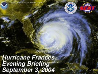
Case Review: 16-17 September 1999.Heavy Rainfall from Landfalling Hurricane-1 Summary of Hurricane Floyd Rainfall Excessive Rainfall occurred with the remains of hurricane Floyd as it moved northward from the mid-Atlantic into New England. Large areas of greater than 4” occurred from eastern Maryland to western New England and the Hudson Valley. Local amounts >9 inches resulted in local flash flooding. Floyd was an example of a hurricane interacting with a mid-latitude baroclinic system to produce excessive rainfall north and west of its track. This is where the low level front provided strong lifting. Maritime tropical air masses typically have the greatest precipitation production in the low levels. Thus, low level frontogenesis and isentropic lift resulted in very efficient precipitation production near the coast.
Case Review: 16-17 September 1999.Heavy Rainfall from Landfalling Hurricane-1 Summary of Hurricane Floyd Rainfall, cont. Further inland in the polar air mass, the freezing level was lower causing a prominent bright band in the radar-derived precipitation (KENX). Topography likely played some role in the localized heavy rain in the northeast, but the meteorological processes would have produced widespread heavy rain anyway. Topography did not play a strong role in the mid-Atlantic compared to the meteorological processes. In fact, low level northerlies were downsloping off southern Appalachians. The low-level precipitation production was typical of maritime tropical air masses. Storm cells were generally low-centroid compared to typical thunderstorms in the mid-latitudes. Thus, the radars were under sampling the precipitation particles at distant ranges, resutling in underestimation of rainfall in those areas.