Download
1 / 12
120 likes | 306 Vues
Modernization of LAPS From LAPS to VLAPS. FAB Data Assimilation Thrust Area. Main Features of LAPS. Multiscale analysis; H otstart with pioneer work in cloud analysis; Efficient for high resolution and frequent analysis cycles; P ortability;

E N D
Modernization of LAPSFrom LAPS to VLAPS FAB Data Assimilation Thrust Area
Main Features of LAPS • Multiscale analysis; • Hotstart with pioneer work in cloud analysis; • Efficient for high resolution and frequent analysis cycles; • Portability; • Ingests a wide range of observational data, in-situ and remotely sensed; • Interface with various forecast models.
Modernization of LAPS: VLAPS • A multigrid variational analysis framework, ideal for truly hybrid, multiscale DA; • Improvement of LAPS hot-start, e.g. T, q, w; • Better balanced analysis, gradually adding constraints and moving toward a multigrid 4DVAR; • Better use of remotely sensed data such as radar and satellite data with CRTM; • The most efficient variational analysis (18 times faster than GSI); • Ease of use and portability inherited from LAPS.
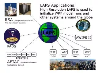
Applications • FAA nowcasting through MIT (surface only at 2.5km); • HWT EWP 2013 (surface at 2.5km and full 3D at 1km) ; • HMT; • AWIPS; • CWB; • Gov’t, Private Sector, Academia, International • 150+ users of LAPS world wide.
HWT1km V-LAPS 0-3h Composite Reflectivity Verification Var. LAPS Initialization Higher ETS (best at short lead time) Compare WRF initialization schemes, work with DTC?
HWT Forecasters’ Input(real time EWP Blog) LAPS again. Higher CAPE, bow echo. Lower CAPE, bye bye bow echo. Posted on May 14, 2013 “In my opinion, the LAPS surface-based CAPE product was one of the stars of the day. Consistently, storms lived and died based on entering and exiting the tongue of higher CAPE values which extended north and northeast from the Big Bend area for most of the day. This first image shows the LAPS surface-based CAPE at 00Z, and the radar at the same time. Shouldn’t be hard to pick out the storm of interest. Note that the storm is still in the tongue of 1000+ J/kg of CAPE as noted on LAPS. One hour later, the storm is exiting and entering a less favorable instability regime. And predictably, it starts to weaken Any questions? LAPS nailed it.” CL SBCAPE 4h Fcst + Radar Obs SBCAPE 3h Fcst + Radar Obs
Moore Tornado Related Blog Entries LAPS Observations and Determining Future Storm Development… Posted on May 20, 2013 “Just a quick post about observationsof the LAPS theta-e fieldthis afternoon.It was interesting to see the near stationary aspect of the theta-e boundary in assoc/w the dryline to our south across portions of north Texas this afternoon. This suggests that continued development is possible late this afternoon especially across northern Texas, where the gradients have been sustained and have even increased lately. However, notice that the gradients have decreased generally across much of Oklahoma where convection and related effects (rain cooled air, cloud shield) have helped to stabilize the environment. The 15-minute temporal resolution of the product can be very useful for diagnosing locations of continued convection especially in rapidly developing convective situations.” 2130UTC 2115UTC 2200UTC 2145UTC LAPS analysis. Shaded values are sfc theta-e (K), while wind vectors are in blue. LAPS niche: Good handle on existing convection and lead time on CI
LAPS System Overview Background (or cycled forecast) Observations Data DataIngest Standalone downscaling module Intermediate data files Analysis Scheme Variational LAPS (with downscaling) Traditional LAPS GSI Downscaling can work as a stand alone module from background → GSI or other applications such as Fire wx. Model prep Downscaling is also an integral part of variational LAPS (aka. STMAS). FORECAST MODEL (e.g.WRF) Verification
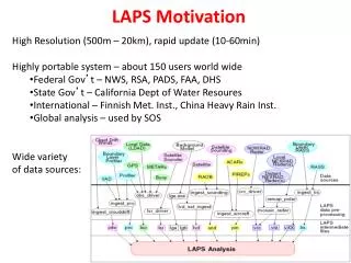
LAPS Motivation High Resolution (500m – 20km), rapid update (10-60min), local to global Highly portable system Collaboration with user community - about 150 world wide • Federal Gov’t – NWS, RSA, PADS, FAA, DHS, SOS • State Gov’t – California Dept of Water Resoures • International – Finnish Met. Inst., China Heavy Rain Inst. • Private Sector – Toyota, WDT Wide variety of data sources: OAR/ESRL/GSD/Forecast Applications Branch *
Transition from Traditionalto Fully Variational LAPS Large Scale Model First Guess Cycling Option state vars, wind (u,v) clouds / precip balance and constraints in multi-scale variational analysis Numerical Forecast model Ultimately Var. LAPS Temporary hybrid system: Traditional LAPS cloud analysis and balance Wind analysis Temp/Ht analysis Humidity analysis Cloud analysis balance Traditional LAPS analysis: Wind, Temp, Humidity, Cloud, Balance
Cloud Analysis Flow Chart Cloud Fraction 3-D Isosurface (From radars and model first guess) *
Future Work • Collaboration on lightning DA (NSSL, Vaisala, NASA etc.) • Satellite sounder DA (CMISS, NESDIS) • Terrain following VLAPS; • Variational cloud analysis inside VLAPS; • Scale dependent ensemble error covariance in multigrid framework (TRULY hybrid); • Dynamic and thermal dynamic balances and moving toward multigrid 4DVAR; • Improvement of use of CRTM;