Download
1 / 14
140 likes | 320 Vues
VIIRS Land PEATE. Masuoka, Wolfe, Isaacman and Devadiga. Land PEATE Overview.

E N D
VIIRS Land PEATE Masuoka, Wolfe, Isaacman and Devadiga
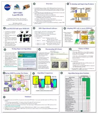
Land PEATE Overview • The NPOESS Preparatory Project (NPP) VIIRS Land Product Evaluation and Algorithm Test Element (PEATE) supports the NPP Science Team in assessing the utility of NPP Land Environmental Data Records (EDRs) for climate research • Land PEATE builds upon the MODIS approach and infrastructure for science team support, product generation and quality assessment • VIIRS product generation software runs in MODAPS • Gridded (Level 3) products (Diagnostic Data Records) facilitate comparison with MODIS products and ground-truth • Products available online for Science Team evaluation • LDOPE (Land Data Operational Product Evaluation) team works with Science Team in evaluating product quality • Land PEATE supports CERES on NPP with reprocessing of VIIRS SDR and aerosol products
Land PEATE Context Diagram CLASS (ADS) SD3E Ancillary Data Providers xDRs, IPs and ancillary data (if unavailable from SD3E) xDRs, IPs and ancillary data PSOE Management direction Ancillary data Algorithm updates Processing requests VIIRS Land PEATE Algorithm updates I&TSE MODAPS MODIS products Test results SDR evaluation results, algorithm updates Pre-flight algorithms, data and information Processing requests SPA Validation NICSE Algorithms & data Algorithm updates xDR evaluation results, algorithm updates Processing requests Data Tools CasaNOSA KEY Known issues, algorithms & data External Systems Ported Algorithm Code SDS Elements Direct Readout Lab SCIENCE TEAM SDS Teams
Land PEATE Architecture - Overview Distribution Database Server Production Database Server Ingest and Staging Servers Ethernet Switch Web and ftp servers Outside Network Outside Network Archive Fast Staging Disk Compute Servers Inexpensive Archive Disk • Uses MODAPS software for processing and distribution • Scalable clusters of inexpensive Intel-based servers running open source software • Now: 16 servers and 20TB storage running VIIRS SCI and OPS s/w and Science Team improvements. • At launch, 120 servers and 600GB storage, run processing at least 10x
Upcoming Milestones • Power installed for servers and storage – September 2008 • 360TB of storage and 40 more servers installed – October 2008 • Upgrade network bandwidth (1GigE to 10 GigE) – December 2008 • Launch-ready build of Land PEATE (Build 3) – March 2009 • Functional thread tests (ingest XDRs, validate XDRs, support Cal.) – June 2009 • “Day in the Life” test with NPP SDS – January 2010
LPEATE L2 PROCESSING CLOUD OPTICAL PROPS FIRE MASK NPPDAPS ARCHIVEPROXY SDRSGRIB FILES GLOBAL GRIDDED DATA CLOUD MASK EVI AND NDVI SNOW GRANULATION LAND SURFACE TEMP SEA ICE AEROSOL SUSPENDED MATTER AEROSOL PARTICLE SIZE SURFACE TYPE LAND SURFACE REFL MODAPS ARCHIVEPROXY SDRSGRIB FILES GLOBAL GRIDDED DATA AEROSOL OPTICAL THICKNESS SCIENCE CODE OPS V1.4 SCI, OPS V1.4,1.5
LPEATE DIAGNOSTIC DATA RECORDS MODAPS ARCHIVEL2 FIRE MASK L2 SURF REFL L2 VEG INDX L2 SURF TEMP L2 SNOW COV L2 SEA ICE 16-DAY BRDF_/ ALBEDO L2G FIREMASK 8-DAY FIREMASK DAILY LAND SURFACE REFL 8-DAY SURFACE REFL COMING FALL 2008 0.0 . 16-DAY VEGETATION INDEX L2G VEGETATION INDEX GLOBAL GRIDDED POINTERS L2G LAND SURFACE TEMP 8-DAY SURFACE TEMP GEOLO- CATION ANGLES 8-DAY SNOW COVER L2G SNOW COVER “POINTER” FILES DAILY GRIDS QUARTERLY SURFACE TYPE L2G SEA ICE 8/16/QUARTERLY GRIDS COMING FALL 2008
LPEATE LEVEL 1 & 2 HDF5->4 AGGREGATOR IDPS 48-SCAN SINGLE-BAND HDF5 PRODUCTS AGGREGATED HDF4 APPROXIMATE 5-MINUTE GRANULES MODERATE RES. SDR BAND M1 MODERATE RES. SDR BAND M1 MODERATE RES. SDR BAND M1 MODERATE RES. SDR BAND M1 MODERATE RES. SDR BAND M2 MODERATE RES. SDR BAND M2 MODERATE RES. SDR BAND M2 MODERATE RES. SDR BAND M2 MODERATE RES. SDR BAND M15 MODERATE RES. SDR BAND M15 MODERATE RES. SDR BAND M15 MODERATE RES. SDR BAND M16 MODERATE RES. SDR BAND M16 MODERATE RES. SDR BAND M16 MODERATE RES. SDR BAND M15 MODERATE RES. SDR BAND M16
NPP Build 1.4/1.5 MODIS Aqua C5 BOWTIE DELETIONS (REMOVED ON REPROJECTION) UNREALISTIC VALUES DUE TO OVERCORRECTION Land Surface Reflectance (2002/222 19:40) Algorithm Comparison
FireMask Algorithm Comparison Science Code Algorithm OPs V1.4 Code Algorithm OPs V1.5 Code Algorithm 2002222 12:45 Namibia Comparison of one scene between Fire Mask generated by the original Science Code algorithm and masks generated by OPs code V1.4 and V1.5 versions of the algorithm. Data were generated using proxy data from MODIS Aqua