Download
1 / 2
30 likes | 248 Vues
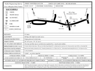
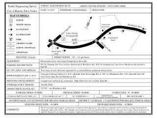
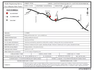
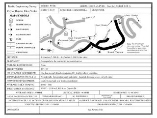
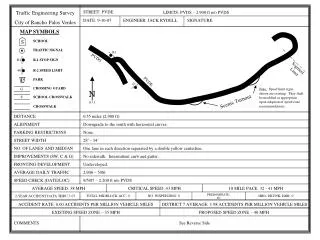
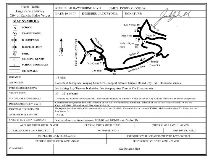
S. N. n.t.s. R1. R1. 40. 45. 45. S. R1. R1. R1. R1. G. STREET: S/B HAWTHORNE BLVD. Truck Traffic Engineering Survey City of Rancho Palos Verdes. LIMITS: PVDW- RHONE DR. DATE: 10-04-07. ENGINEER: JACK RYDELL. SIGNATURE:. MAP SYMBOLS. Los Verdes Dr. SCHOOL. Rhone Dr.

E N D
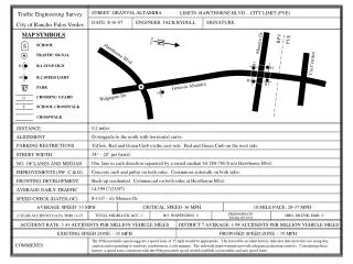
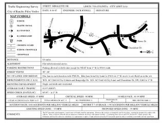
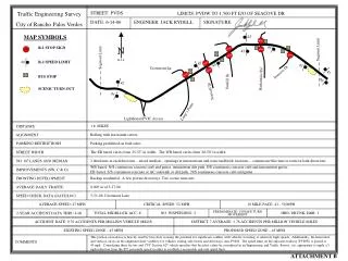
S N n.t.s. R1 R1 40 45 45 S R1 R1 R1 R1 G STREET: S/B HAWTHORNE BLVD Truck Traffic Engineering Survey City of Rancho Palos Verdes LIMITS: PVDW- RHONE DR DATE: 10-04-07 ENGINEER: JACK RYDELL SIGNATURE: MAP SYMBOLS Los Verdes Dr SCHOOL Rhone Dr TRAFFIC SIGNAL Dupre Dr Alta Vista R-1 STOP SIGN Via Rivera Robert Ryan Park R-2 SPEED LIMIT P Palos Verdes Drive West Vallon Dr PARK P CROSSING GUARD Scenic Turn-Out Via Capri SCHOOL CROSSWALK Hawthorne Blvd City Hall CROSSWALK DISTANCE 1.8 miles ALIGNMENT Consistent downgrade ranging from 2-9%, steepest between Dupree Dr and City Hall. Horizontal curves. PARKING RESTRICTIONS No Parking Any Time on both sides. No Stopping Any Time at Via Rivera on w/s. STREET WIDTH 30’ – 32’ per barrel NO. OF LANES AND MEDIAN Two lanes and bike lane in each direction; raised median with median barriers at Vallon Dr and b/t City Hall and Via Rivera; numerous turn pockets. Concrete curb and gutter on both side. Sidewalk on w/s 300’ n/o Vallon Dr to north limit. Sidewalk on w/s 70’ n/o Via Rivera and 370’ n/o Via Capri to PVDW. Sidewalk on w/s 300’ s/o of Vallon Dr. IMPROVEMENTS (SW, C & G) Backup residential both side; Civic and education on e/s n/o City Hall. Commercial at s/e corner of PVDW. Multi-residential n/o Via Rivera and n/o Los Verdes Dr. FRONTING DEVELOPMENT AVERAGE DAILY TRAFFIC 15,156 SPEED CHECK DATA (DATE/LOC) Various dates and times between 9/11/07 and 10/4/07 – s/o Vallon Dr AVERAGE TRUCK SPEED: 24 MPH CRITICAL TRUCK SPEED: 32 MPH TRUCK 10 MILE PACE: 21-30 MPH 2-YEAR ACCIDENT DATA THRU 8-07 NO. W/SPEEDING: 0 HBD, DRUNK, H&R: 0 TOTAL MIDBLOCK TRUCK ACC: 2 PREDOMINATE TRUCK ACCIDENT TYPE: LOST CONTROL EXISTING TRUCK SPEED ZONE- NONE PROPOSED TRUCK SPEED ZONE – 25 MPH COMMENTS See Reverse Side
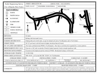
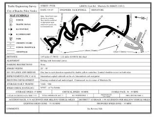
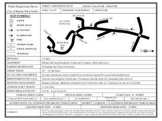
STREET: HAWTHORNE BLVD Truck Traffic Engineering Survey City of Rancho Palos Verdes LIMITS: PVDW - RHONE DR PROPOSED TRUCK SPEED ZONE – 25 MPH Comments: Section 22407 of the California Vehicle Code (CVC) allows local agencies to reduce the speed limit for trucks on downgrades based on the finding of an Engineering and Traffic Survey. This survey was initiated by a recent serious accident involving a commercial vehicle losing control in the southbound direction of Hawthorne Boulevard within the subject limits. The California Manual of Uniform Traffic Control Devices (MUTCD), which is authorized by the CVC as the legal procedure for establishing speed zones, specifies the requirements of an Engineering and Traffic Survey for truck speed zones on descending grades in Section 2B.13. Of specific interest is the following statement, found on page 2B-15 of the September, 2006 version of the California MUTCD: “To establish a downhill truck speed limit, a physical profile showing length and gradient and a downhill speed profile for three or more axle commercial vehicles with a gross rating of 4,536 kg (10,000 lbs.) or more will be provided.” This segment of roadway is generally characterized by two travel lanes and a bike lane in each direction. Between the subject limits, the vertical downgrade to the south ranges from 2% to 9%. There are traffic signals located at Dupree Drive, Vallon Drive and Palos Verdes Drive West. The subject roadway section is heavily used by bicyclists creating the potential for significant conflict with vehicles traveling at relatively high speeds. Additionally, the horizontal and vertical curves in the alignment limit visibility for vehicles exiting side streets and driveways at several intersecting roadways, Ryan Park, City Hall and the commercial development near Palos Verdes Drive West. Radar measurements of 3-axle and more commercial vehicles revealed an 85th percentile speed of 32 mph and a 10-mile pace of 21-30 mph. The 85th percentile speed suggests a truck speed limit of 30 mph would be appropriate. However Robert Ryan Park, located on the west side of Hawthorne Boulevard near Dupree Drive, creates the potential for significant pedestrian and bicycle conflict with vehicles. CVC Section 627 specifies that pedestrian and bicyclist safety be considered when determining a speed limit. Furthermore, The California MUTCD states: “Posted speeds should be on the low side of the scale, generally within the pace of loaded commercial vehicles.” Considering these factors it is appropriate to apply a 5 mph reduction from the 85th percentile speed in order to establish a reasonable and safe truck speed limit on this descending grade portion of Hawthorne Boulevard. Therefore, it is recommended that a 25 mph truck speed zone be established for the southbound direction of Hawthorne Boulevard between Palos Verdes Drive West and Rhone Drive.