Download
1 / 16
180 likes | 306 Vues
Estimating solar pv potential in the cloud. Jonathan Coy GEOG 596A Advisor: jeffrey brownson. Project Background. Concept started during GEOG586 – Geographical Information Analysis capstone project Solar rooftop potential project for a subdivision in Flagstaff, AZ

E N D
Estimating solar pv potential in the cloud Jonathan Coy GEOG 596A Advisor: jeffreybrownson
Project Background • Concept started during GEOG586 – Geographical Information Analysis capstone project • Solar rooftop potential project for a subdivision in Flagstaff, AZ • Processing time too intensive • Classification of results inaccurate • Experimentation with cloud processing during capstone project for GEOG897C – Cloud Server and GIS • LAS Dataset to Raster (Digital Surface Model, DSM) • 9 hours processing time to 6 minutes
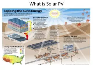
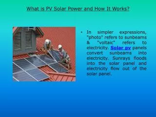
overview • Photovoltaics (PV) is a method of generating electricity by collecting solar radiation from solar panels • Represents a sustainable energy resource • Increasingly important with rising energy costs, global warming, recent increases in technology and events such as the Fukushima nuclear disaster in Japan
ArcGIS “area solar radiation” • Irradiation: is a measure of solar radiation received on a given surface and recorded for a specific time period (energy density units of kWh/m2) • Tool derives incoming insolation from a raster surface • Located within ArcToolbox Spatial Analyst Tools • Extremely processing intensive. Calculations can take hours of even days to run for large scale areas depending on the input parameters • Documentation of input parameters is poor
The amazon cloud advantage • Amazon Web Services offers an easy to use and affordable Infrastructure as a Service (IaaS) called Amazon Elastic Compute Cloud (EC2) • Amazon houses, administers and maintains the hardware, the client pays on a per-use basis • Setup can take minutes and uses ESRI’s pre-configured Amazon Machine Image (AMI). Services can be started and stopped as needed all over a web connection • Allows access to powerful server processing as needed • 9 hours versus 5 minutes • High-Memory Double Extra Large Instance • 34 GB memory, 13 processors, 64-bit, 850 GB storage, Windows • $1.02 per hour
The amazon cloud Disadvantage • Upload and download time of large geospatial datasets • >30 hours upload time • Restrictions with storing datasets offsite • Administration and setup • Remote Desktop access denied through firewall
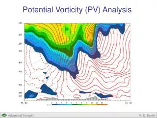
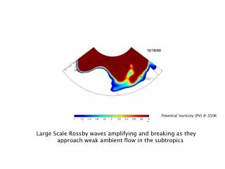
Arcgis“area solar radiation” Deficiencies • With the help of Brownson group several potential deficiencies have been identified within current methodology that the Area Solar Radiation Tool uses to calculate irradiation compared to the “solar community” • Community uses “irradiation” units of J/m2 not kWh/m2 • Area Solar Tool does not calculate what is happening in the real sky day to day; uses fixed global estimations from the user instead of local meteorological data • Results will show how much sun an area receives but will not show what you actually get
Solar Community Methods • National Renewable Energy Laboratory (NREL) • System Advisor Model (SAM) • Simulate many locations as points • Rooftop orientation and slope (obtained from slope and aspect) • Shading factors (tree heights from LiDAR data) • Financials • Typical Meteorological Year (TMY) data • Hourly values of solar radiation and meteorological elements for an entire year • kWh/m2 or J/m2
Meteorological Data Example • Flagstaff hourly data per month for Beam Normal (amount of solar radiation from the direction of the sun) and Global Horizontal (the sum of direct and diffuse radiation)
Locale: FLagstaff • Flagstaff offers an ideal setting to discover shortages of the ArcGIS Solar Radiation tool due to: • Clear skies • Meteorology is likely fairly stable, not complex
Project concept • In the cloud process a digital surface model (DSM) from a LiDAR dataset which covers a portion of NE Flagstaff, Arizona • LiDAR dataset has a 2.38 foot point spacing • Use the DSM as the input raster to calculate incoming insolation for three residential building rooftops in the cloud using “ArcGIS Area Solar Radiation” tool • Outputs will be compared to an energy analysis of the same rooftops using SAM to investigate the differences between
Hypothesis • Total calculated irradiation for the test rooftops using the ArcGIS Area Solar tool will greatly differ from the results produced using SAM and therefore should not be used as a tool by GIS professionals to determine rooftop solar potentials.
Results • If true, recommendations will be made to ESRI regarding how to improve results and why the shortcomings with the tool exist • If false, results will be compared to industry standard practices with explanations as to why the tool produces accurate results
Potential Impact to GIS Community • As more communities and cities use this tool to determine solar potential and share it with the public to push green initiatives it is important the results are accurate or the limitations of the tool are better understood • CH2M Hill Solar Portals – Los Angeles • Risk with small communities with small budgets with access to LiDAR data and ArcGIS start producing such maps on a large scale • Results are not vetted due to processing time and lack of understanding by GIS professionals
Final results • Professional Conference • Solar • GIS/Geography • Journal Article