Download
1 / 30
300 likes | 308 Vues
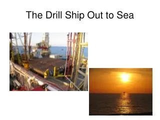
Sea State Alarm trial on cable ship Dock Express 20. Satellite Observing Systems Breeman Engineering and Services bv. Sea State Alarm SSA Service from Satellite Observing Systems Ltd. (SOS) U.K. Twice daily coverage

E N D
Sea State Alarm trial on cable ship Dock Express 20 • Satellite Observing Systems • Breeman Engineering and Services bv
Sea State Alarm • SSA Service from Satellite Observing Systems Ltd. (SOS) U.K. • Twice daily coverage • A map comparing Sea Sate Alarm Significant Waveheight with recent wave forecast (FNOC maps) • E-mail warnings when waves in excess of specified limits are detected • Electronic delivery
Purpose of SSA trial on c.s. Dock Express 20 • Test the usefulness of SSA service • Suggestions and improvements from user point of view • Reasons for c.s. Dock Express 20 • Not a regular marketsegment: • cable laying • slow speeds (typically 0 to 5 1/2 knots) • predefined route • Outfitted with satellite communication equipment • Full co-operation from the vessels crew
c.s. Dock Express 20 LOA = 169 m width = 24.2 m Deadweight 15153 tons 2 x 3128 KW main engines 3 x 1325 KW azimuth thrusters
c.s. Dock Express 20 • Installation of submarine telecommunication cable. • World-wide work-area, all waterdepths, from beach to beach • operational limits: • waveheight approx. 3 - 4 metres from astern • waveheight approx. 4 - 5 metres from ahead • Vessel can not deviate from its intended track. • Regular weather services (weather fax, NAVTEX, SAT-C broadcasts) but also dedicated Oceanroutes forecasts (SATURN) were available. Most of these forecasts are available on a 6 hourly basis.
Communication via internet e-mail DE20 polls data from mailbox at internet service provider via SATCOM - B and or SATCOM-A S.O.S Dock Express 20 B.E.S. bv
Costs: Communication costs per day: E-mail via Satellite per day ~ 90 KB SATCOM-B max 9600 baud ~ U$ 4 - 5 per minute 90 KB 2 minutes U$ 10 cost for vessel S.O.S Dock Express 20 Regular e-mail ~ U$ ½ B.E.S. bv Inmarsat costs estimated rates used from Sation 12, august ‘98
Note on satellite communications: Internet communication dedicated for onshore applications Offshore satellite communications ‘internet protocol’ unfavourable. For relative small amounts of data and with the use of ‘standard’ equipment a much more efficient way for communication is a ‘direct’ computer link over SATCOM - A or B. If SoS has a dedicated computer where the vessel can directly call to the online time can be reduced by at least 50%. Several commercial programs are available for remote computer connections. Then only a data set can be send to the vessel and dedicated software onboard can generate the maps.
SOS Data set Dedicated software Vessel Maps
Costs of weather forecasts: • Regular weather services like Navtex, weather telex via SATCOM-C, weather fax are free of charge. All necessary equipment is compulsary on board. • For services like SSA, sending data in special format, an SATCOM-A, B or mini-M terminal is necessary. Not all (some!) vessels are equipped to receive internet e-mail. • Dedicated weather services: • prices EXCLUDING communication costs! • Oceanroutes (Orion, Saturn,..) ~ U$…. per .. • Data file ~ 200 - 270 KB • Applied Weather techn. (Bon Voyage Syst.) ~ U$ 250- 350 /wk • ...
Input from vessel: • Vessel particulars • Operational limits • Route definition with approximate arrival time • Daily update of progress: • present position • operation details • estimated waveheight at present position • estimated future positions (+24h +48h) • Post analyses / discussion of sea state alarm trial
SSA trail May 1999 San Francisco Predefined cable route July 1999 Guam
Example maps: • General waveheight contour map of FNMOC WAM model • Satellite measurements plotted on top • Area covers Northern Pacific Ocean • Planned route + last reported ship position • Graphical file size around 44 KB • One or two updates per day • Units meters and m/s
FNMOC WAM model waveheight forecast Planned route Vessel position Satellite ground track with measurements
SSA Warning 12Z 12.6.99 Data just received from the satellite indicate that the forecast is seriously in error regarding the storm just to the NE of your location. Forecast wave heights of around 5.0m are actually approaching 7.0m Summary from 09Z 12.6.99 (average over 75km intervals beneath the satellite) (White, ascending track on image) Time (Z) Long Lat Wind Wave 09:19:22 -169.99 41.73 17.68 4.67 09:19:37 -170.30 42.65 18.16 5.62 09:19:41 -170.39 42.88 18.65 6.58 09:19:51 -170.59 43.46 18.74 6.92 09:20:08 -170.94 44.43 16.90 6.48 09:20:15 -171.11 44.89 15.44 5.50 09:20:28 -171.39 45.63 13.89 4.74
June 14 th 09 Z: • Observation on board: • Westerly winds 55 knots gusts 60+ knots • Estimated waveheight 7 - 8 metres
SSA Warning 12Z 14.6.99 This measurement is probably close enough that you already know! Wave heights of 7.0m have been recorded by the satellite approximately 300km west of your location. (Forecast had been for 5.0m) Time (Z) Long Lat wind wave 09:55:58 -178.47 39.17 14.57 6.23 09:56:05 -178.60 39.57 16.03 6.69 09:56:17 -178.83 40.26 16.12 6.49 09:56:29 -179.06 40.95 16.61 6.86 09:56:42 -179.31 41.70 16.41 6.74 09:56:49 -179.47 42.15 17.00 6.41 09:57:01 -179.71 42.84 17.77 6.26
discrepancy discrepancy
Conclusions of captain Dock Express 20 after trial: • Data was considered correct, measurements close to vessel position were accurate. • Graphical presentation is clear, best is to cover a large area of interest • No operational decisions were made on basis of SSA data. This conclusion is based on the fact that route deviations are not possible. • Send SSA warnings by FAX, vessel can then poll the data • Data was used to confirm other weather forecasts • General experience was that WNI oceanroutes wavemodel forecast was overestimating. Therefore it was neglected. Regular available forecasts we used instead. • SSA gave early warning to unpredicted adverse weather conditions • Size of data ~45 KB (= transmission time )was considered reasonable, especially when compared to Oceanroutes’ data (200 - 270 KB) • Future improvements: • increase density of satellite ground tracks > GANDER • merge data into ‘general’ forecasts
Additional conclusions: • Owners view : No overlapping / double services. • Presently not a replacement for regular forecast services • Only applicable at open sea • Integrated service needs to be developed • Blend data into predictions • Append WIND speed / direction and wave direction / period • Wavedata subdivided into two components (sea / swell ?) if feasible • Increase satellite density (The SSA warning issued at june 14th was far too late ) • General impression was that FNMOC wavemodel was generally underestimating. • Based on Hs, wavemodel seems OK on average. However higher seastates seem to be underestimated. Lower seastates seem to to overestimated.