Download
1 / 2
30 likes | 164 Vues
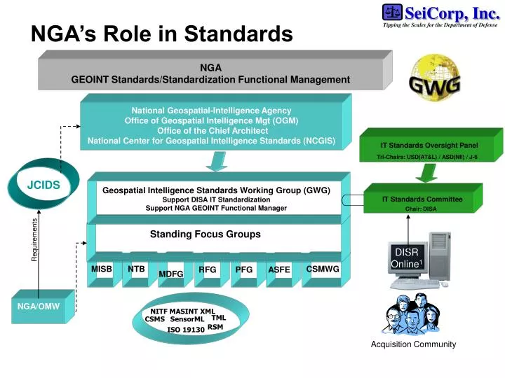
NGA’s Role in Standards. NGA GEOINT Standards/Standardization Functional Management. National Geospatial-Intelligence Agency Office of Geospatial Intelligence Mgt (OGM) Office of the Chief Architect National Center for Geospatial Intelligence Standards (NCGIS).

E N D
NGA’s Role in Standards NGA GEOINT Standards/Standardization Functional Management National Geospatial-Intelligence Agency Office of Geospatial Intelligence Mgt (OGM) Office of the Chief Architect National Center for Geospatial Intelligence Standards (NCGIS) IT Standards Oversight Panel Tri-Chairs: USD(AT&L) / ASD(NII) / J-6 JCIDS Geospatial Intelligence Standards Working Group (GWG) Support DISA IT Standardization Support NGA GEOINT Functional Manager IT Standards Committee Chair: DISA Standing Focus Groups Requirements DISR Online1 MISB NTB MDFG CSMWG RFG PFG ASFE NGA/OMW NITF MASINT XML TML CSMS SensorML RSM ISO 19130 Acquisition Community 1Approved IT Standards & IT Standard Profiles
Effective & Efficient Generation of Precision Coordinates* to meet the Warfighters Needs! S2AG Airborne Sensor Study Weighted model to determine prioritization of “next” sensors/platforms Refinement to inputs CSM SM (API) S2AG - Identifies Standards needed across the architecture to transport the metadata necessary to support precise geopositioning - TCPED / TPPU ISO 19130 Sensor Model Focus (Frame, push, whisk, SAR) GWG CM ? OGC ISO 19130 - International Standard - Architecture Independent - Driven by precise geopositioning requirements - NWIP CSMWG Whitepapers Frame Push Broom Whisk Broom Metadata Focus Group Sensor Model Precise Geopositioning* Metadata SAR Next Sensor Complete Metadata Set